
Kessach
|
Kessach left main line upper course: Schillingstadter Kästle |
||
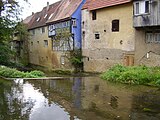
 The Kessach in Unterkessach |
||
| Data | ||
| Water code | DE : 238852 | |
| location |
Building land
|
|
| River system | Rhine | |
| Drain over | Jagst → Neckar → Rhine → North Sea | |
| source | of the longer upper course Berolzheimer Kästle : a good 2 km northeast of Berolzheim 49 ° 29 ′ 7 ″ N , 9 ° 33 ′ 52 ″ E |
|
| Source height | approx. 383 m above sea level NHN | |
| muzzle | in Aries from the right into the Jagst coordinates: 49 ° 19 ′ 0 ″ N , 9 ° 25 ′ 15 ″ E 49 ° 19 ′ 0 ″ N , 9 ° 25 ′ 15 ″ E |
|
| Mouth height | approx. 182 m above sea level NHN | |
| Height difference | approx. 201 m | |
| Bottom slope | approx. 7.6 ‰ | |
| length | 26.4 km with OL Berolzheimer Kästle |
|
| Catchment area | 73.797 km² | |
| Discharge A Eo : 71.9 km²
|
MQ 1951-1990 Mq 1951-1990 |
600 l / s 8.3 l / (s km²) |
The Kessach is a 26.4 km long creek with its longer right upper course with an approximately south-south-western course through northern Baden-Württemberg , which flows into the Jagst from the right in the small town of Widdern in the Heilbronn district . Its upper reaches are the right Berolzheimer Kästle and the left Schillingstadter Kästle
geography
Headwaters
The Kessach arises about two kilometers north of Hüngheim on the southern edge of a large forest area from the confluence of its upper reaches Berolzheimer Kästle and Schillingstadter Kästle or simply Kästle in the Gewann Seegrund . Although the right Berolzheimer Kästle is evidently the more important upper course in terms of both length and sub-catchment area, the official waterway map, perhaps because of the greater constancy of direction from that to the Kessach, sees the left Schillingstadter Kästle as the main upper course of the Kessach, with which it then becomes one Length of only 24.0 km.
The Schillingstadter Kästle is being built between the villages of Berolzheim and Schillingstadt in the municipality of Ahorn about 250 meters east of junction 5 of the A 81 at about 360 m above sea level. NHN at the intersecting federal road 292 and flows from here without tributaries or settlement on the course to the southwest, initially in the more open corridor, later in a narrow strip of floodplain in the forest.
The Berolzheimer Kästle arises about 2.1 km northeast of Berolzheim on the edge of the forest at about 383 m above sea level. NHN . It takes up some ditches on its south-west course, which like it itself mostly follow dirt roads, including the Berolzheimer ditch in the south of the eponymous village. In the following forest run it is accompanied by a narrow strip of floodplain and turns abruptly to the southeast less than 1.5 km before the confluence with the Schillingstadter Kästle, now and almost to the end in the area of the municipality of Rosenberg .
course

The Kessach itself arises at about 308 m above sea level. NHN already in the area of the city of Ravenstein . It flows steadily in a south to south-westerly direction and reaches the village of Hüngheim von Ravenstein a good two kilometers downhill. This is soon followed by the village of Merchingen on the river, after whose residential area Untere Mühle the bank remains uninhabited for a long time and even borders on the left side of the hillside forest in the area of the municipality border to Schöntal . In the village of Oberkessach , the shell-limestone valley of the Kessach is now 80–100 meters from the edge heights. Below there is a longer stretch under forest slopes, now on both steep sides of the valley. In between, the smaller village of Unterkessach in the small town of Widdern lies on the banks of the river. Finally, old settlement parts of the central Aries fill the valley floor. The Kessach then flows into Aries at about 182 m above sea level. NHN from the right and finally north a little before the river bridge in the lower Jagst .
The Kessach is, calculated from the source of the Berolzheimer Kästles, 24.6 km long and falls on this route by about 201 meters, the mean bed gradient is about 0.8 ‰. On average, 0.6 m³ / s flow off at the mouth. According to this criterion, it is the sixth largest tributary of the Jagst .
Tributaries and lakes
Hierarchical list of tributaries and ![]() lakes from source to mouth. Length of water, lake area, catchment area and altitude according to the corresponding layers on the LUBW online map. Other sources for the information are noted. Selection.
lakes from source to mouth. Length of water, lake area, catchment area and altitude according to the corresponding layers on the LUBW online map. Other sources for the information are noted. Selection.
Confluence of Kessach to about 308 m above sea level. NHN about 2.1 km north of the center of the village of Hüngheim in the small town of Ravenstein in the Gewann Seegrund .
-
Berolzheimer Kästle , right and north-northeast upper reaches, 8.3 km and 15.9 km². Arises as a dirt road ditch at about 383 m above sea level. NHN about 2.1 km northeast of the center of Berolzheim at the tip of a corridor corner between the Lindich and Seligwald forest spans .
- Berolzheimer Graben , from the right and north to about 330 m above sea level. NHN south of Berolzheim at a field lane crossing, 2.3 km and 1.9 km². Arises at about 274 m above sea level. NHN north of Berolzheim.
- Schillingstadter Kästle , left and north-northeastern upper reaches, 5.9 km and 7.2 km². Arises at about 360 m above sea level. NHN about 250 meters east of the junction of the federal highway 292 on the federal highway 81 .
- Klingengraben , from the left and southeast to about 290 m above sea level. NHN in Ravenstein - Hüngheim , 0.8 km and approx. 0.4 km². Arises at about 321 m above sea level. NHN am Gewann Outer Seelein .
-
Langenackergraben , from the right and northwest to about 274 m above sea level. NHN shortly before Ravenstein- Merchingen , 3.0 km and 8.6 km². Arises at about 326 m above sea level. NHN in the great forest just across the highway.
- Eßbachgraben , from the right and west to about 280 m above sea level. NHN shortly before the mouth of the Langenackergraben, 2.8 km and approx. 2.1 km². Arises at about 364 m above sea level. NHN about 400 meters north of the Osterburken junction in the summer forest .
- Knockgraben , from the right and northwest to about 267 m above sea level. NHN at the lower mill of Merchingen, 2.9 km and approx. 2.1 km². Arises at about 338 m above sea level. NHN at the Osterburken junction.
- Hackgraben , from the right and west to about 260 m above sea level. NHN , 2.6 km and 2.5 km². Arises at about 357 m above sea level. NHN next to the L 1046.
- Pfaffengraben , from the right and northwest to about 248 m above sea level. NHN in front of Schöntal- Oberkessach , 1.3 km and 0.9 km². Arises at about 325 m above sea level. NHN next to the L 1046.
- (Bach vom Sümpfle ), from the right and north-northwest to about 242 m above sea level. NHN at the sewage treatment plant to Oberkessach, 3.0 km and 2.4 km². Arises at about 340 m above sea level. NHN am Wald Denzer and the motorway.
-
Brühlgraben , from the right and northwest to about 239 m above sea level. NHN shortly after the previous one, 2.5 km and 2.2 km². Arises at about 340 m above sea level. NHN am Gewann Upper Dancer .
- With a little shorter right upper branch, which is close to the motorway at about 333 m above sea level. NHN rises from the Heumahdbrunnen .
- (Bach through the Heiligenklinge ), from the right and northwest to 230.8 m above sea level. NHN shortly before the next on the border between Schöntal-Oberkessach and Widdern- Unterkessach , 1.7 km and 0.7 km². Arises at about 335 m above sea level. NHN near Schöntal- Weigental .
-
 Passed at about 229 m above sea level. NHN half a dozen small fish ponds right ha at maturity, together 0.1.
 - (Stream from the birch forest ), from the left and southeast to about 226 m above sea level. NHN on the same boundary as above, 0.6 km and approx. 0.3 km². Arises at about 310 m above sea level. NHN in the Birkenwald forest district .
- (Bach through the Reutersklinge ), from the right and north-northwest to about 224 m above sea level. NHN , 1.2 km and about 0.7 km². Arises at about 315 m above sea level. NHN below the Weigentaler Höhe .
- (Bach von der Heubirken ), from the left and southeast to about 223 m above sea level. NHN less than a hundred meters after the previous one, 1.2 km and about 0.9 km². Arises at about 334 m above sea level. NHN .
- Hahnengraben , from the right and north to about 219 m above sea level. NHN in Unterkessach , 2.7 km and 2.7 km². Arises at about 325 m above sea level. NHN from side ditches of the motorway in the Gewann Rote Straße .
- (Stream through the Eberklinge ), from the right and north to about 210 m above sea level. NHN to Unterkessach, 1.8 km and approx. 2.6 km². Arises at about 305 m above sea level. NHN on the southern edge of Widdern- Volkshausen .
-
Immediately afterwards passes a pond fed by the executioner's well on the lower slope to the right of the run at a little over 210 m above sea level. Above sea level , 0.2 ha.
- (Waldbach vom Obernberg ), from the left and east-southeast to about 205 m above sea level. NHN , 1.2 km and approx. 0.9 km². Rises at about 299 m above sea level. NHN .
- (Bach from the Völesklinge ), from the right and west to about 203 m above sea level. NHN under the valley climb of the K 2023, 0.7 km and approx. 1.6 km². Arises as a dirt road ditch at about 283 m above sea level. NHN next to the motorway and flows in a side blade into the lowest section of a long, predominantly southeast- facing dry valley Ödlesklinge or Döttlesklinge .
Mouth of the Kessach from the right and finally north to about 182 m above sea level. NHN in Aries in the lower Jagst . The brook is 26.4 km from the origin of the longer upper course Berolzheimer Kästle , from the confluence of the two upper courses only 18.1 km long and has a catchment area of 73.8 km².
Nature and protected areas
The valley has from the crossing on Widderner district share in the conservation area Kessachtal with adjacent parts of territories . In the Kessach there is a good stock of brown and rainbow trout , the Mühlkoppe (bullhead) can be found, which speaks for a good water quality. The kingfisher also lives on the river, and there are also inhabited beaver dams between Hüngheim and Merchingen, as well as Unterkessach and Widdern.
tourism
The Kessachtal cycle path runs in the valley.
gallery

Unterkessach weir

Wooden footbridge in Unterkessach

Scene on the Kessach in midsummer
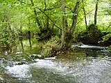
Kessach between Unterkessach and Aries
Kessach passes the old town of Widdern

Kessach estuary
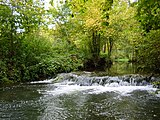
Some of the numerous ...

... small waterfalls ...

... the Kessach.


See also
References and comments
LUBW
Official online waterway map with the appropriate section and the layers used here: Course and catchment area of the Kessach
General introduction without default settings and layers: State Institute for the Environment Baden-Württemberg (LUBW) ( notes )
- ↑ a b Muzzle height interpolated between two heights in blue lettering above and below in the Jagst on the background layer topographic map .
- ↑ a b Length according to the waterway network layer ( AWGN ) .
- ↑ a b Catchment area summed up from the sub-catchment areas according to the basic catchment area layer (AWGN) .
- ↑ Lake area after the layer standing waters .
- ↑ Catchment area according to the basic catchment area layer (AWGN) .
- ↑ Height according to the contour line image on the topographic map background layer .
- ↑ The on the background layer Topographic Map as Berolzheimer Käst le labeled upper course contributes to the layer water network (AWGN) the name Berolzheimer Käst lein , while the adjacent Schilling Stadter Käst le by two sources coincident the dialectal basic word in the name wears. The only one-time writing box is probably due to an oversight.
- ↑ a b c d e f g h i Catchment area measured on the background layer topographic map .
- ↑ Height according to the blue lettering on the background layer topographic map .
Other evidence and comments
- ↑ Wolf-Dieter Sick : Geographical land survey: The natural space units on sheet 162 Rothenburg o. D. Deaf. Federal Institute for Regional Studies, Bad Godesberg 1962. → Online map (PDF; 4.7 MB)
literature
- Topographic map 1: 25,000 Baden-Württemberg, as single sheet No. 6522 Adelsheim (only for the catchment area), No. 6523 Boxberg, No. 6622 Möckmühl and No. 6623 Ingelfingen
- Hans Mattern : The lower Jagsttal. From Dörzbach to the mouth . Baier BPB Verlag, Crailsheim 2005, ISBN 3-929233-27-4 .