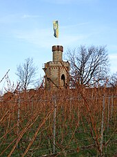
Flag tower
| Flag tower | ||
|---|---|---|
 Flag tower |
||
| Data | ||
| place | Bad Dürkheim , Rhineland-Palatinate | |
| Construction year | 1854 | |
| height | 10 m | |
| Floor space | approx. 36 m² | |
| Coordinates | 49 ° 27 '7 " N , 8 ° 10' 8.8" E | |
|
|
||
| particularities | ||
| eight-sided floor plan | ||
The flag tower, popularly known as the “coffee mill” because of its shape, is a two-storey tower on the top of the Fuchsmantels at 224 m above sea level, southwest of Bad Dürkheim .
The hill lies at the northern end of the Haardt mountain range, where it drops to the Isenach valley. From here one overlooks the Upper Rhine Rift Valley to the east, the mountains of the Leininger Sporn to the north and the Palatinate Mountains with the Drachenfels ( 570.8 m ) to the west .
construction
The 10 m high tower is a sandstone building in neo-Gothic style with an eight-sided floor plan. It has two floors. The ground floor consists of an open domed hall, which is accessible on the south side via a five-step flight of stairs and a pointed arched door, and is broken up with three pointed arched windows. The doors and windows, which are partially glazed in the pointed arch area, are intended to symbolize the four seasons with different motifs. An external sandstone staircase leads to the 5.4 m high surrounding external platform. This is bordered with a 1 m high parapet, the battlements of which have some orientation arrows to prominent sights. A clockwise spiral staircase leads from the first platform to the detached, slimmer part of the tower with the second, 9 m high viewing platform , but the metal lattice door in front of the staircase is usually locked. The flagpole is used on special occasions, such as the city festival or the sausage market .
history
In 1854 the tower was an expression of the growing prosperity in the Bad Dürkheim saltwater pool . The construction was financed by donations from the citizens of Bad Dürkheim and was supposed to represent another attraction of the spa town . Due to its attractive location, the tower was well received by visitors as a viewing platform. At the beginning of 2002, ownership of the tower passed to the Drachenfels Club , which had already taken care of the maintenance and support of the building.
Location
The tower stands on a hill southwest of Bad Dürkheim. It allows a view over the Rhine plain to the Odenwald and Black Forest . In the northeast you can see the Taunus with the Großer Feldberg when the weather is clear . The flag tower is also one of the few places outside the Rhine plain from where both the Wachtenburg and the Limburg monastery ruins can be seen.
Circular hiking trail
The tower is advertised from Bad Dürkheim along with an approximately 8 km long circular hiking trail “Towers and Monasteries”, which leads past the Seebach monastery church and the Zeppelin tower .
Web links
References and comments
- ↑ a b Drachenfels-Club: Der Flaggenturm ( Memento of the original from January 31, 2016 in the Internet Archive ) Info: The archive link was inserted automatically and has not yet been checked. Please check the original and archive link according to the instructions and then remove this notice.
- ↑ Archived copy ( memento of the original from October 11, 2008 in the Internet Archive ) Info: The archive link was inserted automatically and has not yet been checked. Please check the original and archive link according to the instructions and then remove this notice.
- ↑ a b c d Information based on measurements carried out privately
- ↑ hiking trail

