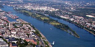
Arm of the river

Brown loop at the bottom right: artificial main arm (from approx. 1480)
Short brown section above: Old Danube : sole Danube until approx. 1480, then oxbow lake and now a navigable tributary
The arms of a river are the streams into which the river branches at one point (viewed in the direction of flow). They can then reunite and thus form a river island , or they flow as estuary arms separated into a larger body of water, usually the sea. Rivers, the course of which branches out into several arms, are typical of the morphological water types anastomosing river and intertwined river . Especially with the second type, the switched-on islands merge into gravel and sandbanks without a fixed border .
Very rarely does it happen that an arm of a running water does not reunite with the water from which it branched off, but with another water. This case is called a river bifurcation .
Distinctions
poor
At medium water levels, one arm of a river branch has no or no significantly less importance than the other arm for the discharge. In the river section of an arm there is no main arm, but it usually consists of two and rarely more arms.
Feature :
- There is no main arm in the area of an arm
Examples:
Mombacher Arm and Kasteler Arm of the Rhine at the level of the Petersaue near Mainz
Left and right arm of the Seine in Paris at the level of the Île Saint-Louis and Île de la Cité
Main arm
A main arm is an arm of a river branch with the predominant runoff / flow rate at medium water levels (definition according to DIN 4054 and VV-WSV object catalog, see under literature).
Tributary
A tributary is the tributary of a river branch, which at medium water levels has less importance for the discharge and possibly for shipping traffic and usually has a lower flow velocity than the main arm (definition according to DIN 4054 and VV-WSV object catalog, see under literature ).
Side arms arise when the river bed branches off on a river island or on a sand or gravel bank (called “middle ground” in shipping), but also through artificial punctures when the river is straightened . If side arms are no longer flowed through at mean water, they are called flood channels or flood troughs (with natural bed) or flood canal or flood ditch (with artificial water bed). These serve to relieve the main channel during floods .
Features :
- Connection at both ends to the main stream
- Constantly flowing through
Example: Alte Donau in Straubing (see picture above)
Old arm
An oxbow lake (also known as a dead arm ) is the part of a river that is cut off at one end from the main stream by natural (sand or gravel bank) or artificial ( weir or dam ) action. Old arms are often shallower than the main arm. Since there is no more or only little flow through them, they have more the character of a still water and tend to become swampy or even silted up . They form an important habitat for birds and insects and are often designated as nature reserves or landscape protection areas. Oxbows usually do not arise naturally from branches of a branched river, but rather when the river breaks through such a loop at a narrow point in a strongly winding river bed with meandering formation and thus shortens the course. In Central Europe, however, many of them were created by artificial, hydraulic engineering piercing of the meander, for example to improve the navigability of the river. If there is no longer any connection to the main stream on either side, the backwater becomes the backwater .
Features :
- Connection to the main stream only at one end
- There is little flow (e.g. only via a bottom outlet ) or there is no longer any flow, except during floods
Example: Saumain in Schweinfurt
Oxbows and tributaries are sometimes grouped together under the term side arm.
Muzzle arm
An estuary (often just arm or river arm ) is an arm of a river in a river delta .
feature
- Only occurs in an estuary
Examples:
River delta to the sea: Lek and Waal at the mouth of the Rhine
River Delta am See: Alter Rhein at the mouth of the Alpine Rhine in the Bodensee
Branch and Fork
In the English-language names of non-European rivers, Fork does not refer to an arm, but to a source river : The “fork” here - viewed upstream, from the perspective of the explorers - is the confluence. In river names, Branch can stand for both river arms and source rivers.
channels
A canal that is connected to the river at both ends and takes part of the runoff is not considered an arm of the river. Rivers sometimes have a side channel, which is fed by river water and parallel to the river bed, which is used for inland navigation (e.g. the Rhine side channel ). Others serve technical purposes, e.g. B. sluice channels, power plant channels, engine channels (such as mill ditches or mill arms).
See also
literature
- DIN 4054 hydraulic engineering; Terms; September 1977
- Administrative regulation of the Federal Waterways and Shipping Administration (VV-WSV), 11 02 - Object catalog (ObKat), edition 2005. (4th amendment 2014) published by the Federal Ministry of Transport and Digital Infrastructure.


