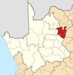
Frances Baard (District)
| Frances Baard Frances Baard District Municipality |
||
|---|---|---|
 |
||
| Symbols | ||
|
||
| Basic data | ||
| Country | South Africa | |
| province | North Cape | |
| Seat | Kimberley | |
| surface | 12,836 km² | |
| Residents | 382,086 (October 2011) | |
| density | 30 inhabitants per km² | |
| key | DC9 | |
| ISO 3166-2 | ZA-NC | |
| Website | www.francesbaard.gov.za (English) | |
| politics | ||
| mayor | Buyisma Ximba | |
Coordinates: 28 ° 45 ′ S , 24 ° 46 ′ E
Frances Baard is a district in the province of Northern Cape in South Africa . It has 382,086 inhabitants (as of October 2011) on a total area of 12,836 km², making it the smallest district in the North Cape. The capital of the district is Kimberley . The district is named after the politician Frances Baard (1901–1997). The largest rivers are Vaal , Oranje , Riet, Modder and Harts.
- Neighboring Districts
- Dr Ruth Segomotsi Mompati
- Lejweleputswa
- Pixley Ka Seme
- Xhariep
- ZF Mgcawu (formerly Siyanda )
- John Taolo Gaetsewe
Municipalities with their largest cities
- Sol Plaatjie
-
Phokwane with 63,314 inhabitants on 834 km²
- Blyvooruitsig, Hartswater, Jan Kempdorp , Pampierstad, Valspan
- Dikgatlong
-
Magareng
- Ikutseng, Warrenton , Warrenvale
National parks and nature reserves
- Kamfersdam
- Mokala National Park
- Witsand Nature Reserve
Web links
- The district website (English)
- Portrait at localgovernment.co.za (English)
Individual evidence
- ^ Census 2011. Basic Results. (PDF; 349 kB) Statistics South Africa , accessed on November 27, 2015 (English).
- ^ Municipal boundaries South Africa
- ↑ Meaning of the name municipalities
