Gölcük (Kocaeli)
| Gölcük | ||||
|
||||
| Basic data | ||||
|---|---|---|---|---|
| Province (il) : | Kocaeli | |||
| Coordinates : | 40 ° 40 ′ N , 29 ° 50 ′ E | |||
| Residents : | 130,141 (2008) | |||
| Telephone code : | (+90) 262 | |||
| Postal code : | 41650 | |||
| License plate : | 41 | |||
| Structure and administration | ||||
| Mayor : | Ali Yıldırım Sezer ( AKP ) | |||
| Website: | ||||
| District of Gölcük | ||||
| Residents : | 136,513 (2008) | |||
| Surface: | 207 km² | |||
| Population density : | 659 inhabitants per km² | |||
| Kaymakam : | Cengiz Karabulut | |||
| Website (Kaymakam): | ||||
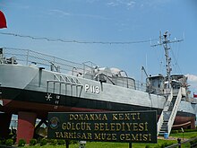
Gölcük is a district in the Turkish province of Kocaeli . The district has a population of 136,513 (as of 2008) on an area of 207 km². The district town with 130,141 inhabitants is also called Gölcük. The district of Gölcük borders directly on the Bay of İzmit . The Turkish Navy has a base in Gölcük.
Golcük was the center of the Gölcük earthquake on August 17, 1999, which left thousands of deaths.

Sports
Gölcükspor is the most famous and most successful football club in town. The club had its most successful time in the years 1984-1985, in which the club in the second highest Turkish league, the TFF 1st Lig , was active. After the club withdrew from the league competition as a result of the Gölcük earthquake , it returned to Turkish professional football in the summer of 2002 and has since played in the TFF 3rd Lig , the fourth highest league in Turkey.
Personalities
- Demet Akalın (* 1972), Turkish singer and model
- Hakan Çinemre (* 1994), Turkish football player
- Ertuğrul Ersoy (* 1997), Turkish football player
- Engin Korukır (* 1958), Turkish football coach
- Ahmet Özer (* 1994), Turkish soccer player
Web links
Individual evidence
- ↑ a b Turkish Institute for Statistics ( Memento from December 22, 2012 in the web archive archive.today ), accessed November 20, 2009


