
Gamrig
| Gamrig | ||
|---|---|---|
 View of the Gamrig |
||
| height | 253.2 m above sea level HN | |
| location | Saxony ( Germany ) | |
| Mountains | Elbe Sandstone Mountains | |
| Coordinates | 50 ° 57 '30 " N , 14 ° 5' 49" E | |
|
||
| Type | Table Mountain | |
| rock | Sandstone | |

The Gamrig is a 253 meter high mountain in the Upper Saxon Switzerland east of Rathen . Due to its free-standing location above the village, it offers a far-reaching view over the Elbe Sandstone Mountains , especially over the Elbe Valley and the flatness .
Location and surroundings
The Gamrig is located about one kilometer east of Rathen on the northwestern edge of a plateau (flatness) on which the village of Waltersdorf lies. To the south of the rock massif, a valley floor has cut into the subsoil, through which the Waltersdorf - Niederrathen road runs directly past the Gamrig. To the west of the Gamrig lies the Rathener rock area with a number of well-known rocks (including Bastei , Mönch , Lokomotive ) and grounds (including Wehlgrund , Amselgrund ). About one kilometer northeast is the canyon-like valley of the Polenz . Between Gamrig and Polenztal lies the narrow, wooded rock plateau Ziegenücken, over which the state road 163 runs from Bad Schandau to the Hocksteinschänke.
history
The name Gamrig comes from Slavic , it is traced back to came , the Slavic word for "stone".
In contrast to other free-standing rocks and rock groups in Saxon Switzerland, such as the Falkenstein or the Neurathen Castle , the Gamrig never served as a castle watchman. The Gamrig was already mentioned in Matthias Oeder's First Saxon Land Survey in 1592 . There he was still called Gamigkstein . The term Gammerig was also used until the 20th century .
Caspar David Friedrich drew the Gamrig in 1808 and used the motif in 1818 in his famous painting The Wanderer over the Sea of Fog .
Due to its easy accessibility, Gamrig has often been a film location. In 1981, for example, some scenes from the Police Call 110 episode “The Lifeguard” were filmed on the Gamrig . In 2017, the second part of the TV series Der Ranger - Paradies Heimat was shot here.
geology
The Gamrig is a remnant of what was once a uniform rock slab, which also included the neighboring rock massifs of Carolastein (251 meters), Fritschenstein (259 meters) and Bockstein (246 meters). The rock slab rose about 20-40 meters above the Waltersdorfer plateau.
The Gamrig consists of grade d sandstones , which are classified in the geological time scale in the upper Turon of the Cretaceous period . In more recent publications these sandstones are also referred to as " Schrammstein layers ". Originally, step d was up to 50 meters thick.
At a height of about 220 meters, the clayey-sandy intermediate layer γ3, which is exposed to severe weathering, is inserted between steps d and c. On the south side of the Gamrig a layer joint cave (" Gamrighöhle ") was created in this intermediate layer , which was artificially expanded in the 19th century (see below.)
Due to the relatively soft layers of sandstone, the entire rock massif of the Gamrig is at great risk of erosion .
Mountain sports
On the Gamrig, which is part of the Rathen section of the Saxon Switzerland climbing area , there are six climbing peaks, " Gamrigkegel ", " Gamrigscheibe ", " Gamrigwächter ", " Heidebrüderturm ", " Heidestein " and " Waltersdorfer Horn " with over 130 different climbing routes. Since the sandstone around Rathen is very soft and brittle due to its fine grain and lack of binding agents, the rocks suffer particularly from erosion . According to the Saxon climbing rules, climbing after rain is only allowed after the rocks have dried off completely.
view
For hikers, the views on the Gamrig are accessible via a stepped climb. You have a wide view to the city of Wehlen , to the locomotive and over Lilienstein and Königstein fortress to the Zirkelstein and the Schrammsteinen .
Paths to the summit
On the west side of the rock massif, a stepped path leads to the summit. In contrast to numerous other mountains and viewpoints in Saxon Switzerland, the summit plateau is not secured with railings.
Gamrig Cave
At the foot of the wall on the southeast side of the Gamrig there is the " Gamrighöhle ", a half-cave between two sandstone layers (layer joint cave ). The fine and poorly solidified sandstone here was broken out in the second half of the 19th century and ground into fine sand. This was sold as washing up sand, scouring sand and cleaning sand as well as for sprinkling wooden floorboards, mainly in inns and soap factories. The cave was expanded through the extraction of sandstone and today extends over 20 meters deep into the Gamrig rock.
gallery

The Gamrig (left center) on the Oberreit map from 1821/22

“ The Wanderer Above the Sea of Fog ” by Caspar David Friedrich (1818) shows the Gamrig rock massif to the left of the wanderer

Way to the Gamrig

on the summit of the Gamrig, in the background the Elbe valley between Rathen and the city of Wehlen can be seen
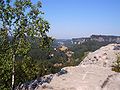
View from Gamrig to the west
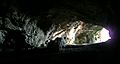
in the "Gamrig Cave"

Climbers on the Heidestein, one of the six climbing peaks on the Gamrig


.JPG)
.JPG)

.JPG)

Individual evidence
- ↑ Peter Rölke (Ed.): Wander- & Naturführer Sächsische Schweiz, Volume 2 , Berg- & Naturverlag Peter Rölke, Dresden 2000, ISBN 3-934514-09-X , p. 60
- ↑ Documentation of the GDR-FS / DFF , German Broadcasting Archive (DRA) Potsdam-Babelsberg
- ↑ Dietmar Heinicke (ed.): Climbing Guide Saxon Switzerland . Volume Wehlenergebiet, Rathenergebiet, Brand, Berg- & Naturverlag Rölke, Dresden 2003, ISBN 3-934514-06-5 , p. 258 ff.
- ↑ Peter Rölke (Ed.): Wander- & Naturführer Sächsische Schweiz, Volume 2 , Berg- & Naturverlag Peter Rölke, Dresden 2000, ISBN 3-934514-09-X , p. 65
- ↑ http://www.hm-noroc.de/lilienstein/am_fusse_des_liliensteins/petermannhoehle.html
literature
- Königstein area, Saxon Switzerland (= values of the German homeland . Volume 1). 1st edition. Akademie Verlag, Berlin 1957.
- Alfred Meiche : Historical-topographical description of the Pirna administration . Dresden 1927
- Peter Rölke (Ed.): Hiking & Nature Guide Saxon Switzerland, Volume 2 , Berg- & Naturverlag Peter Rölke, Dresden 2000, ISBN 3-934514-09-X