
Gartower firs
Coordinates: 52 ° 57 ′ 54 ″ N , 11 ° 27 ′ 55 ″ E


The Gartower Firs (often also called Gartower Forest ) are a forest area within the non-parish Gartow area in Lower Saxony on the border with Saxony-Anhalt .
geography
The Gartower fir trees cover an area of more than 5600 hectares in the eastern Wendland , southeast of Hamburg . The area lies on sand deposits in the glacial valley of the Elbe at an altitude of about 20 to 25 m above sea level. NN . The highest point is on the Kellerberg and reaches 32 m above sea level. NN . It is bounded to the north by the valley of the Seege and to the east by Harper Moor . In the south are the headwaters of the Lucie Canal and the Arendsee , to the southwest it merges into the Nemitzer Heide , to the west the Lucie adjoins and the terrain descends towards the Jeetzel lowlands .
history
In Carolingian times, the extensive hunting ground between the Franks , Slavs and Saxons was fought over and eventually became part of the Franconian Empire . In the early 14th century it belonged to the Gartow office that gave its name today, and around 1700 it came into the possession of the von Bernstorff family . These are still the owners of the forests, which are considered the largest contiguous private forest area in Germany. The area was administered and managed from the hunting and forestry enclave Wirl .
After the First World War , the Kapermoorsche Bahn ran in an east-west direction through the forest area. It served peat and forestry and connected to the west of the Lüchow-Schmarsauer Railway . At Wirl, an almost five kilometer long branch line, the Wirler Bahn, branched off to the north and ended at the former Rucksmoor Vorwerk . In order not to chase away the game and because of the risk of forest fires, horses instead of locomotives pulled the wagons.
In the 1940s, numerous storm, Pest and were in the Gartower fir war damages by Hermann Junack investigated and resolved in subsequent years.
Since the 1970s, federal road 493, which runs through it in an east-west direction, has divided the forest area into a northern and a southern section. In 1975 the fire in the Lüneburg Heath destroyed part of the forests. It was partly reforested , partly some areas remained fallow land and in addition some extinguishing water ponds were created. The Nemitzer Heide was built on an area that had been abandoned by the forest fire. In 1980 there was a brief protest camp of the anti-nuclear power movement on another wasteland , in which the Republic of Free Wendland was proclaimed and which is being researched from 2016 to 2018 through the archaeological investigation of the "Republic of Free Wendland" .
Flora and fauna
The area is densely composed of coniferous forest and uninhabited. The old stocks of white moss pine forest and the typical associations with berry plants and sour grasses , which provide shelter and food for the species-rich wild stocks, are remarkable . The Gartower fir trees are now also an area where wolves can expect . After the animals were exterminated there in the middle of the 19th century, individual individuals who could have founded their own pack are now being sighted again. In July 2014, a litter of young animals was observed by a wildlife camera .
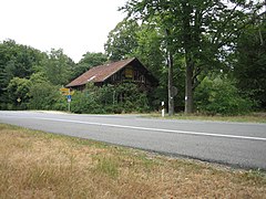
Forsthaus Rondel in the Gartower Tannen on the B 493 (2010)

Fire water pond (2016)
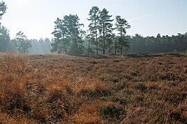
Heathland (2012)
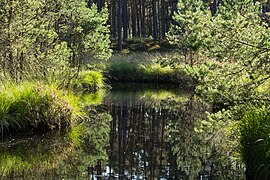
Kleinmoor eastern Gartow firs (2016)

Klaus-Bahlsen -Turm, in the background the northern edge of the Gartower Tannen near Neu-Rucksmoor (2011)


Web links
- Picture gallery Gartower Tannen
- Picture gallery red deer and wild boar in the Gartower fir trees
- Picture gallery poultry in the Gartower fir trees
Individual evidence
- ↑ Gartower Firs
- ↑ Gartower Tannen at Geoportal Niedersachsen ( page no longer available , search in web archives ) Info: The link was automatically marked as defective. Please check the link according to the instructions and then remove this notice.
- ↑ Wirler Bahn
- ↑ Pine stands in the Gartower firs
- ↑ Wolf couple in the Gartower fir trees
- ↑ Wolferwartungsgebiet Gartower Tannen on Google Maps
- ↑ Young wolves in the Gartower Forest