Gasimur
|
Gasimur Gazimur |
||
|
|
||
| Data | ||
| Water code | RU : 20030200112118100002255 | |
| location | Transbaikalia Region ( Russia ) | |
| River system | Amur | |
| Drain over | Argun → Amur → Tatar Sound | |
| source |
Nertscha Mountains 50 ° 43 ′ 23 ″ N , 117 ° 29 ′ 13 ″ E |
|
| Source height | approx. 1100 m | |
| muzzle |
Argun coordinates: 52 ° 56 ′ 10 " N , 120 ° 20 ′ 58" E 52 ° 56 ′ 10 " N , 120 ° 20 ′ 58" E |
|
| Mouth height | 343 m | |
| Height difference | approx. 757 m | |
| Bottom slope | approx. 1.3 ‰ | |
| length | 592 km | |
| Catchment area | 12,100 km² | |
|
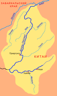
Location of the Gasimur (Газимур) in the catchment area of the Argun |
||
The Gasimur ( Russian Газимур ) is a 592 km long left tributary of the Argun in Transbaikalia ( Russia , Asia ).
course
The Gasimur rises at an altitude of around 1100 m on the northern flank of the Nertscha Mountains ( Lukowyje Kamni , 1297 m), which is almost 1300 m high . It initially flows in mostly northeast to northern directions through a wide valley. From the middle reaches the river separates the northwestern Borschtschowotschnygebirge from the southeastern Gasimur Mountains . The valley narrows more and more towards the lower reaches, and the river takes on the character of a mountain. It turns in a south-easterly direction before flowing into the Amur source river, Argun, at a height of 343 m , which forms the border between Russia and the People's Republic of China .
The Gasimur has no major tributaries. In its entire course it flows through the Transbaikalia region .
Hydrography
The catchment area of the Gasimur covers 12,100 km². Near the mouth, the river is over 60 meters wide and one to two meters deep; the flow velocity is 1.0 m / s.
Depending on the rainfall, the Gasimur often leads to strong floods in the summer months.
Infrastructure and economy
The Gasimur is not navigable.
There are a number of places in the area of the upper and middle reaches of the Gasimur, and it is relatively well developed with partially paved roads. The largest settlements are the district administrative centers of Alexandrowski Zavod and Gasimurski Zavod . The regional road R430 leads through Alexandrowski Sawod from Nerchinsky Sawod via Borsja to Solovyovsk on the border with Mongolia , through Gasimurski Sawod the R429 from Sretensk to Nerchinsky Sawod.
The lower 250 kilometers of the river are practically uninhabited; here the infrastructure is limited to unpaved roads.
Together with the Russian Railways, Norilsk Nickel is planning to build a 375-kilometer-long railway line , branching off from the southern line to Krasnokamensk to the valley of the middle Gazimur, to the local molybdenum , antimony , copper , gold and others To develop ore deposits. The project planning work should be completed by the end of 2009.
Individual evidence
- ↑ a b Article Gasimur in the Great Soviet Encyclopedia (BSE) , 3rd edition 1969–1978 (Russian)
- ↑ a b Gasimur in the State Water Register of the Russian Federation (Russian)
- ↑ Report on the conclusion of the contract between Norilsk Nickel and the State Railways ( Memento of the original from September 27, 2007 in the web archive archive.today ) Info: The archive link was automatically inserted and not yet checked. Please check the original and archive link according to the instructions and then remove this notice. (Russian)
