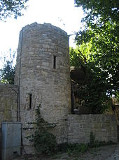
Geyerschloss
The Geyerschloss in Giebelstadt , a market in the Lower Franconian district of Würzburg ( Bavaria ), was originally built in the 14th century. The moated castle with the address Am Geyerschloß 7 is a protected architectural monument .
history
A "Greed von Gibelstat" from the Geyer von Giebelstadt family built this castle on the southern edge of the village. The three-wing complex with round towers at the corners had a deep moat over which a drawbridge led. In the autumn of 1441 the Geyerschloss was destroyed by the Rothenburgers as a punitive action for their incursions into the Rothenburg area. It was then rebuilt as a three-winged Renaissance moated castle. A later owner was Florian Geyer , who led the Tauberhaufen in the Peasants' War .
Heinrich Wolfgang von Geyer was raised to the rank of count by Emperor Leopold I in 1685. With him, the Geyer von Giebelstadt family died out in 1708. The castle then fell to the Margrave Wilhelm Friedrich von Ansbach-Brandenburg. Gottfried Ludwig Zobel acquired the castle in 1746. From the property of the farmers Heiner (1784), Keller and Müller (1820), the municipality of Giebelstadt took over the Geyerschloss in 1861 , the northern wing of which had already collapsed. The castle fell into disrepair and served as a quarry. It was not until 1925, when the open-air stage for the Florian Geyer Games was built on the site, that the remains of the facility were protected. The ruins were destroyed by an air raid on Giebelstadt in World War II and then rebuilt.
The ruins served from 1925 to 1938 and again since 1980 as the backdrop for the annual Florian Geyer Games.
literature
- Georg Dehio : Handbook of the German art monuments. Francs. The administrative districts of Upper Franconia, Middle Franconia and Lower Franconia . Edited by Tilmann Breuer et al., Deutscher Kunstverlag, Munich 1979, p. 309.
Web links
- Geyerschloss . In: WürzburgWiki
- Homepage of the Florian Geyer Games
Coordinates: 49 ° 39 '2.7 " N , 9 ° 56" 46 " E


