Glimke
|
Glimke (Glimbach) |
||
|
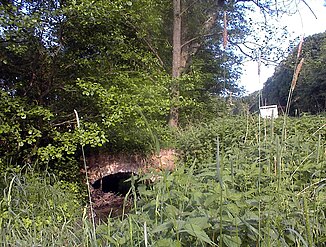
Bridge over the Glimkebach |
||
| Data | ||
| Water code | DE : 46282 | |
| location | North Rhine-Westphalia , Germany | |
| River system | Weser | |
| Drain over | Salts → Bega → Werre → Weser → North Sea | |
| source | For deserts 52 ° 5 ′ 50 ″ N , 8 ° 49 ′ 30 ″ E |
|
| Source height | approx. 195 m above sea level NN | |
| muzzle | At Exter in the salts coordinates: 52 ° 7 '22 " N , 8 ° 46' 40" E 52 ° 7 '22 " N , 8 ° 46' 40" E |
|
| Mouth height | approx. 95 m above sea level NN | |
| Height difference | approx. 100 m | |
| Bottom slope | approx. 16 ‰ | |
| length | 6.2 km | |
| Catchment area | 13.1 km² | |
| Left tributaries | Desert Bieke | |
| Right tributaries | Glimke | |
| Medium-sized cities | Bad Salzuflen | |
| Small towns | Vlotho | |
The Glimke (or Glimbach ) is a 6.2 kilometer long left tributary of the salts in the northeast of the German state of North Rhine-Westphalia .
geography
The catchment area stretches across part of the Lipper Bergland northeast of Bad Salzuflen and north of the Bega .
The water rises northeast of deserts in the Pillenbruch district, gathers below the Boberg , then flows past the Kixmühle, Siebeneichen, below Pehlen at the Schwabedissen farm to the Glimke district. From here, the Glimke forms the district boundary ( Lippe district - Herford district ) and thus at the same time the city boundary ( Bad Salzuflen - Vlotho ) and flows into the Salze at Detmolder Strasse in the Vlotho area.
On its way, the Glimke takes in the following waters when viewed downstream:
- Glimke (tributary of the same name) (R 5.4)
- Wüstener Bieke (L, 2.2)
- The Wüstener Bieke rises between Boberg, Erd- and Wiensiek. It initially flows parallel to Kirchheider Straße towards Kätchenort / Altes Dorf , underground past the former garbage dump and parallel to Glimkestraße until it flows into the Glimke.
(L / R; KM): Left right inflow, at river kilometers, mouth at KM 0)
history
The origin of the name is uncertain and perhaps goes back to the Glimberg (nd. Glimmerg ). This in turn could have its origin in Glintberg (nd. Rock, cliff, stone ). A church path led over the Glimkebach over a (still existing) bridge to the Wüsten church. The bridge was also used as a weir to flood meadows, it is still assumed that a farm mill that has been documented, but no longer exists, is still possible at times.
environment
Large parts of the Glimketal are designated as nature reserves “ Glimketal ” (LIP-040) and “ Salze-Glimketal ” (HF-035).
