Godenswege
|
Godenswege
City of Stargard Castle
Coordinates: 53 ° 27 ′ 27 ″ N , 13 ° 17 ′ 18 ″ E
|
|
|---|---|
| Height : | 116 m above sea level NHN |
| Area : | 6.51 km² |
| Residents : | 96 (Jul 4, 2017) |
| Population density : | 15 inhabitants / km² |
| Incorporation : | July 1, 1950 |
| Incorporated into: | Holldorf |
| Postal code : | 17094 |
| Area code : | 039603 |
|
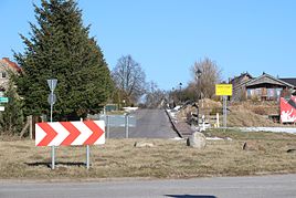
South-western entrance to the village
|
|
Godenswege is a district of the town of Burg Stargard in the Mecklenburg Lake District in Mecklenburg-Western Pomerania .
geography
The place is five kilometers south-southwest of the town of Burg Stargard and eleven kilometers south of Neubrandenburg . The Godenswege district has a north-south extension of six kilometers and an east-west extension of half a kilometer to two kilometers. It extends in the north and south to the Rowa Forest, is largely unforested and an open agricultural landscape . The neighboring towns are Sabel in the northeast, Riepke in the east, Cammin in the southeast, Blankensee in the southwest, Ballwitz in the west and Holldorf and Rowa in the northwest.
history
The first written mention of the place can be found in a document from 1356. In it it was recorded under its current name.
On December 1, 1910 Godenswege had 128 inhabitants and until January 31, 1919 the place was administered by the Knightly Office of Stargard. Previously an independent municipality in the Stargard district , Godenswege was incorporated into Holldorf on April 1, 1937. With the dissolution of the district, the place came to the newly formed district of Neubrandenburg in 1946 . In the meantime, the place was spun off again and came back to Holldorf on July 1, 1950. On October 1, 1961 Godenswege moved to the municipality of Cammin and through the incorporation of Cammin into the town of Burg Stargard, the place became a district there on May 25, 2014.
Buildings
The list of monuments of the Mecklenburg Lake District includes two monuments in the village. Including the syringe house on Godensweger Strasse.
traffic
The district road MSE 84 , which leads to Burg Stargard and Cammin, runs through the village . In addition, there are smaller connecting roads to Blankensee and Holldorf from the roundabout on the southwestern outskirts.
literature
- Literature about Godenswege in the state bibliography MV
- The land of Stargard . In: Art and history monuments of the Free State of Mecklenburg-Strelitz . On behalf of the Ministry (Department of Education and Art). I. Volume, III. Department: The district court districts Friedland (2nd half), Stargard and Neubrandenburg - processed by Georg Krüger, Oberkirchenrat zu Neustrelitz. Commission publisher of the Brünslowsche Verlagsbuchhandlung (E. Brückner), Neubrandenburg 1929, District Court District Stargard - Godenswege, p. 139 ( online [accessed July 5, 2017]).
Web links
- Godenswege in the historical directory of the association for computer genealogy
Individual evidence
- ↑ Geoportal. Mecklenburg Lake District - Lower Surveying and Geoinformation Authority, March 31, 2016, accessed on July 7, 2017 .
- ^ Office Stargarder Land - main office (ed.): Population figures of the city of Burg Stargard with the municipalities belonging to the office. Status: 04/07/2017 . Stargard Castle 4th July 2017.
- ↑ Main statute of the city of Burg Stargard . April 10, 2019, § 1 - Name / coat of arms / flag / official seal - 2) - ( Sitzungsdienst-stargarder-land.de [PDF; 5.5 MB ; accessed on September 30, 2019]).
- ↑ a b Geodata Viewer of the Office for Geoinformation, Surveying and Cadastral Affairs Mecklenburg-Western Pomerania ( notes )
- ^ Georg Krüger: The land of Stargard. 1929, p. 139.
- ↑ Michael Rademacher: German administrative history from the unification of the empire in 1871 to the reunification in 1990. (Online material for the dissertation, Osnabrück 2006).
- ^ Municipal directory Germany 1900. In: gemeindeververzeichnis.de. Ulrich Schubert, accessed on February 17, 2017 .
- ↑ Federal Statistical Office (Ed.): Municipalities 1994 and their changes since 01.01.1948 in the new federal states . Metzler-Poeschel, Stuttgart 1995, ISBN 3-8246-0321-7 , pp. 135 .
- ↑ State Office for Internal Administration Mecklenburg-Western Pomerania - Office for Geoinformation, Surveying and Cadastre (Ed.): Directory of the localities Mecklenburg-Western Pomerania with height and coordinate information . 2008.
- ↑ Area changes from January 01 to December 31, 2014. Federal Statistical Office (Destatis), September 26, 2014, accessed on February 17, 2017 .
