May Ayim shore
| May Ayim shore | |
|---|---|
| Street in Berlin | |
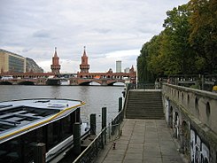
| Pier on May-Ayim-Ufer, in the background the Oberbaum Bridge |
|
| Basic data | |
| place | Berlin |
| District | Kreuzberg |
| Created | 1891 |
| Hist. Names | Groebenufer (until 2009) |
| Connecting roads |
Pfuelstrasse, Oberbaumstrasse |
| Cross streets | Bevernstrasse |
| use | |
| User groups | Pedestrian traffic , bicycle traffic , car traffic |
| Technical specifications | |
| Street length | 275 meters |
The May-Ayim-Ufer (formerly: Groebenufer , or Gröbenufer ) is a street in the Berlin district of Kreuzberg in the Friedrichshain-Kreuzberg district .
Location and history
The street runs from Pfuelstraße in the northwest to Oberbaumstraße ( Oberbaumbrücke ) in the southeast and forms the banks of the Spree .
The Uferstraße was laid out after 1891 and, on the occasion of the upcoming “ colonial exhibition ” in the nearby Treptower Park, was provided with an elaborately designed mooring in maritime style.
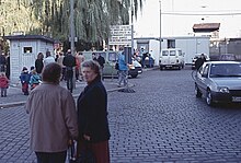
During the time of the division of Berlin , the sector boundary ran along the Gröbenufer , with the full width of the Spree belonging to East Berlin . This situation was the cause of a number of tragic accidents in the 1960s and 1970s. Andreas Senk drowned in 1966 after being pushed into the water. West Berliners did not dare to save the six-year-old, while the GDR border troops did not notice the incident. At least four other West Berlin children drowned here in the Spree because the rescue workers on the West Berlin bank were forbidden to intervene by the border troops of the GDR: Cengaver Katrancı (9), Siegfried Kroboth (5), Giuseppe Savoca (6) and Çetin Mert (5). They could climb through the wide openings in the cast-iron parapet - only then did they come up with the idea of attaching close-meshed wire mesh throughout. With the policy of détente , a unique system was also installed on this bank of the Spree: Special emergency telephones (water accident alarms), which gave the GDR border organs optical and acoustic signals, whereupon they issued a special permit for rescue measures from West Berlin in the same way. Several people, including Udo Düllick and Anton Walzer , perished while trying to escape from the GDR through the Spree and reach what was then the Gröbenufer . Memorial crosses and stones in memory of the victims were placed on the bank.
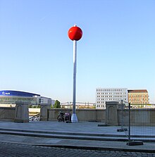
On the May-Ayim-Ufer is a historic double wharf , in the middle of which a lighthouse stood until it was destroyed in World War II . In the course of a renovation of the facility from 2008, the associated underground catacombs were made accessible to the public and a ship landing stage was set up again. Instead of the lighthouse, a red signal ball designed by the artist Ulrike Mohr was installed, which moves up and down on a ten meter high aluminum mast depending on the ship traffic on the Spree. The official reopening took place on August 29, 2011. A restaurant has existed here since 2010.
Naming
Groebenufer
The famous street name encyclopedia of the Luisenstädtischer Bildungsverein names April 4, 1895 as the name giver of the more well-known today
-
Otto Friedrich von der Groeben (1657–1728);
founded the Brandenburg colony of Groß Friedrichsburg in what is now Ghana in 1683 as head of a West Africa expedition on behalf of the Great Elector .
However, at least one contemporary source - the address book for Berlin and its suburbs compiled "using official sources" in 1899 - states that the bank is sloping
-
Karl Graf von der Groeben-Neudörfchen (1788–1876);
1853-1858 named Commanding General of the Guard Corps. This would mean that the colonialism aspect of the renaming discussion that took place in the summer of 2007–2009 would be irrelevant.
The street name lexicon Katzur had listed both as namesake in 1987; In an earlier edition in 1969 it also said: Originally ... after Otto ... An earlier edition of the Luisenstädtischer Bildungsverein reported in March 1993: 1895 named after Count Karl ... - according to another interpretation, after Otto ...
Because of this ambiguity was by the Group of the Alliance 90 / The Greens of the district council (BVV) Friedrichshain-Kreuzberg commissioned a report commissioned. In the report of the historian Dr. J. Kundler named the letter from the Prussian Minister of Public Works Karl von Thielen dated February 14, 1895, which was received on February 17, 1895 in the Emperor's Secret Civil Cabinet . Here was listed under point 4:
- “For the left-hand side of the Spreeuferstraße between Oberbaum Bridge and Straße 5b of Section I of the development plan for the area around Berlin , Majors Otto Friedrich von. Is in honor of the first Brandenburg Colonial Governor, the builder of the fortress Gross-Friedrichsburg on the coast of Guinea, Major Otto Friedrich von the Groeben applied for the name 'Groeben-Ufer'. "
The naming of this bank section of the street 5b then took place at the same time as the dedication of the adjacent section as Pfuelstraße after Ernst von Pfuel .
May Ayim shore
At the suggestion of the Berlin Development Policy Advice initiative , which was taken up by the Bündnis 90 / Die Grünen parliamentary group , the Friedrichshain-Kreuzberger BVV decided in spring 2009 to rename the Gröbenufer after the anti-racist activist and poet May Ayim (1960-1996), because Groeben of The Brandenburg-African Company had enabled a participation in the transatlantic slave trade by founding Groß-Friedrichsburg . The street was officially renamed on March 4, 2010. A formal rededication and the installation of new street signs took place on February 27, 2010.
The colonial historian Ulrich van der Heyden accused the renaming initiative of committing "gross character assassination" of Otto Friedrich von der Groeben . According to van der Heyden, the company's commanding officer helped create “the material prerequisites for the inhuman transatlantic slave trade”, but “had nothing to do with it personally”. The initiative saw a contradiction in this and presented evidence of Gröben's participation in the Kurbrandenburg slave trade project, without being able to prove that Groeben had made use of a contractually granted opportunity to acquire slaves personally.
See also
Web links
- May Ayim shore. In: Street name lexicon of the Luisenstädtischer Bildungsverein (near Kaupert )
literature
- Clara Ervedosa: The May-Ayim-Ufer in Berlin . In: Jürgen Zimmerer (Ed.): No place in the sun. Places of remembrance of German colonial history . Frankfurt 2013. ISBN 978-3-593-39811-2 , pp. 424-441.
- Ulrich van der Heyden: Red eagles on Africa's coast. The Brandenburg-Prussian colony Großfriedrichsburg on the West African coast . 2nd Edition. Berlin 2001 (1st edition 1993).
- Ulrich van der Heyden: Otto Friedrich von der Groeben. Founder of Großfriedrichsburg . In: Die Mark Brandenburg, No. 67 . Berlin 2007.
- Ulrich van der Heyden, Joachim Kundler: Otto Friedrich von der Gröben - adventurous traveler, writer and controversial namesake of the Gröben bank on the Spree . In: Berlin in the present and history . Yearbook of the Berlin State Archives, Berlin 2010, pp. 7–32.
- Hans-Jürgen Mende (Ed.): Lexicon 'All Berlin Streets and Squares' - From the foundation to the present . 2nd volume. New Life / Edition Luisenstadt, Berlin 1998, ISBN 3-355-01491-5 , p. 145 .
Individual evidence
- ↑ Renewal of the double wharf on May-Ayim-Ufer (formerly Gröbenufer) . stadtumbau-berlin.de, as seen on May 9, 2011
- ↑ Art object on the May-Ayim-Ufer double quay (formerly Gröbenufer) . stadtumbau-berlin.de, as seen on May 9, 2011
- ↑ stadtumbau-berlin.de ( page no longer available , search in web archives ) Info: The link was automatically marked as defective. Please check the link according to the instructions and then remove this notice.
- ^ For example, 1998 edition, Volume 2, page 145; currently reproduced with identical text in Kaupert's street guide; cached February 10, 2010 ( memento of February 10, 2010 on WebCite ) at WebCite
- ↑ Gröben-Ufer . In: Address book for Berlin and its suburbs , 1899, part 3, p. 213. - also all subsequent years
- ↑ Klaus Katzur: Berlin's street names: their origin and meaning . 2nd Edition. Haude & Spener, Berlin 1987, ISBN 3-7759-0296-1 .
- ^ Klaus Katzur: Berlins street names - historical personalities on street signs . Haude & Spener, Berlin 1969. (Berlin reminiscences 23)
- ^ Herbert Mayer: Signpost to Berlin's street names - Kreuzberg . Edition Luisenstadt, Berlin 1993, p. 70.
- ↑ Press release April 21, 2009 ( Memento of the original from March 4, 2016 in the Internet Archive ) Info: The archive link was inserted automatically and has not yet been checked. Please check the original and archive link according to the instructions and then remove this notice. (PDF 12kB)
- ^ Secret State Archives of Prussian Cultural Heritage , TA I HA Rep. 89 No. 14456 Bl. 191–196
- ↑ Pfuelstrasse. In: Street name lexicon of the Luisenstädtischer Bildungsverein (near Kaupert )
- ↑ Press release May 20, 2009 of the Berlin Development Council
- ↑ archive.org Clear the way for women who fight against racism. ( Memento from October 11, 2009 in the Internet Archive ) In: taz , May 25, 2009
- ^ Official Journal for Berlin from November 20, 2009
- ↑ rbb aktuell , February 27, 2010
- ↑ Gross character assassination of von der Gröben . In: Neues Deutschland , June 13, 2009; Retrieved March 22, 2010
- ↑ See Christian Kopp's dossier, especially p. 4 (contractual possibility) and 6 (the lack of evidence): Christian Kopp: “Mission Moriaen” - Otto Friedrich von der Gröben and the Brandenburg-Prussian slave trade . ( Memento of the original from March 17, 2014 in the Internet Archive ) Info: The archive link was inserted automatically and has not yet been checked. Please check the original and archive link according to the instructions and then remove this notice. (PDF; 905 kB)
Coordinates: 52 ° 30 ′ 8 ″ N , 13 ° 26 ′ 35 ″ E


