
Grünthal (Schönsee)
|
Grünthal
City of Schönsee
Coordinates: 49 ° 29 ′ 42 ″ N , 12 ° 31 ′ 57 ″ E
|
||
|---|---|---|
| Height : | 615 m | |
| Residents : | 0 (Dec 12, 2012) | |
| Postal code : | 92539 | |
| Area code : | 09674 | |
Location of Grünthal in Bavaria |
||
 Grünthal
|
||

Grünthal is a district of the town of Schönsee in the Upper Palatinate district of Schwandorf in Bavaria .
Geographical location
Grünthal is a single house that stands at the exit of the Rosenthal in the direction of Schönsee on the right side of the state road 2159 . The trout stream flows into the Ascha near Grünthal .
Culture and sights
A cycling and hiking trail leads past Grünthal, which was laid out on the former Nabburg – Schönsee railway line . This cycle path is a section of the Bavarian-Bohemian Friendship Trail from Nabburg to Horšovský Týn .
photos
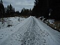
Bike and hiking trail on the former Nabburg-Schönsee railway line near Grünthal

The Ascha near Grünthal


Web links
Individual evidence
- ↑ Schönsee residents' registration office
- ↑ Fritsch hiking map Schönseer Land, scale 1: 35000
- ↑ http://www.oberpfaelzerwald.de/de/bayerisch-boehmischer-freundschaftsweg

Buchenberg | Dietersberg | Dietersdorf | Eulenberg | Friedrichshäng | Gaisthal | Gaisthaler hammer | Grünthal | Rear Lindau | Johannismühle | Josephsthal | Foliage | Lilienthal | Lindau | Muggenthal | Upholstery | Rackenthal | Rosenhof | Rosenthal | Schönsee | Schwand | Weber houses | Brick hut
former districts: Schallerhammer | Stückhäusl | Wagner Mill