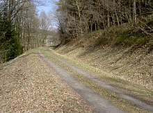
Bavarian-Bohemian Friendship Path
The Bavarian-Bohemian Friendship Path (Czech: Bavorsko - česká stezka přátelství) is a 97 km long cross-border long-distance cycle path from Nabburg to Horšovský Týn in the Czech Republic .
From Nabburg to Schönsee it runs as a railway cycle path on the former Nabburg – Schönsee railway line . From Schönsee it runs on back roads with little traffic. Between Schönsee and Poběžovice it overcomes the Upper Palatinate Forest at a height of approx. 700 m . It ends in Horšovský Týn in the Plzeňská pahorkatina , a hilly landscape with wide valleys and characteristic elevations, which are often crowned by castles, chateaus or churches.
Location and course
The Bavarian-Bohemian Friendship Trail begins in Nabburg in the Schwandorf district . It initially runs on the former Nabburg – Schönsee railway line through the Upper Palatinate Forest and Northern Upper Palatinate Forest nature parks . From Schönsee to the Czech border in Schwarzach, it overcomes a 710 m high ridge of the Upper Palatinate Forest on roads with little traffic. After crossing the border in Schwarzach, the long-distance cycle path overcomes another 750 m high mountain ridge and enters the gentle hilly landscape of the Plzeňská pahorkatina. Via Poběžovice it leads mostly on low-traffic roads to Horšovský Týn.
history
In 1913 the 38 km long Nabburg - Schönsee railway was put into operation. Passenger train traffic on this line was stopped in 1978. Until 1993 there was a daily freight train to Lind . Finally, the Nabburg - Oberviechtach railway line was completely shut down on February 1, 1995. The use of the railway line as a cycle and hiking trail began as early as 1991, initially between Schönsee and Lind.
At the end of the 20th century, the existing cycle path on the former Nabburg – Schönsee railway line was extended to the east. The extension used existing sections of the green roof cycle path in Germany and cycle path number 2141 in the Czech Republic. This expansion was financed with funds from the European Union . The Bavarian-Bohemian Friendship Path leads via Poběžovice, the residence of the Coudenhove-Kalergi family . Here lived Richard Nikolaus Coudenhove-Kalergi , who with his writings and ideas influence on the founding of the European Union.
Web links
- Bavaria cycle route planner
- bike paths Bavaria, only German part
- German and Czech part
- in detail in German and Czech with map and sights
- in short, with e-bike charging stations
Individual evidence
- ↑ a b Bavarian-Bohemian Friendship Path on www.oberpfaelzerwald.de, accessed on January 18, 2018
- ↑ Historical Atlas of Bavaria: Altbayern series I issue 61: Oberviechtach p. 4, 5
- ↑ Bavarian-Bohemian Friendship Path, on www.stezkapratelstvi.eu, accessed on June 14, 2018
