Grieselstein
|
Grieselstein ( village ) locality cadastral community Grieselstein |
||
|---|---|---|
|
|
||
| Basic data | ||
| Pole. District , state | Jennersdorf (JE), Burgenland | |
| Judicial district | Gussing | |
| Pole. local community | Jennersdorf | |
| Coordinates | 46 ° 57 ′ 0 ″ N , 16 ° 7 ′ 11 ″ E | |
| Residents of the village | 665 (January 1, 2020) | |
| Building status | 270 (2001 ) | |
| Area d. KG | 814.51 ha (2018) | |
| Post Code | 8380 Jennersdorf | |
| Statistical identification | ||
| Locality code | 00093 | |
| Cadastral parish number | 31107 | |
| Counting district / district | Grieselstein (10504 002) | |
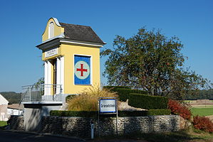
 Marienkapelle in Grieselstein |
||
| Source: STAT : index of places ; BEV : GEONAM ; GIS-Bgld | ||
Grieselstein ( Hungarian: Köröstyén ) is a place in southern Burgenland in the Jennersdorf district , Austria and a cadastral municipality of the Jennersdorf municipality .
geography
The village with 665 inhabitants (January 1, 2020) is on the way between the Loipersdorf thermal baths and the town of Jennersdorf. The Grieselbach flows through the village.
Attractions
- Lady Chapel: The Lady Chapel is renovated and is located at the entrance to the village
- Stoagupf: The Steinberg von Grieselstein, a volcanic cone, is popularly called Stoagupf and is one of the oldest settlement areas in Burgenland. Finds of ceramic fragments point to a Neolithic settlement, but also to a medieval complex from the 13th to 14th centuries. A large part of the complex was destroyed by the mining of volcanic rock at the beginning of the 20th century. Today the entire area is under monument protection ( list entry ).
tourism
The village of Grieselstein also benefits from the Loipersdorf thermal baths in the neighborhood, on the road between Jennersdorf and Bad Loipersdorf . Since the opening of the thermal baths in 1982, numerous hotels and restaurants have been expanded and expanded.
Web links
Commons : Grieselstein - Collection of images, videos and audio files

