
Great Weser Arch

The Great Weserbogen is a bend in the river Weser near Bad Oeynhausen in North Rhine-Westphalia .
location


Most of the Great Weserbogen is in northeastern North Rhine-Westphalia . The introduction of the bow begins at Hessisch Oldendorf in Lower Saxony . The Great Weserbogen is the last section of the Upper Weser . In the area of the Upper Weser, the Weser flows roughly north through the Weser Uplands , where its course is largely determined by the topography of the area, before it leaves the low mountain range regions immediately after the Great Weser Arch through the Porta Westfalica and flows through the north German lowlands in the Mittelweser section .
The Weserbogen presents itself as a large bend in the river that breaks out in the usual south-north direction. The Weser breaks out of its previous direction of flow far west at Hessisch Oldendorf and flows south of the Süntel and Weser Mountains north around the elevations of the Lipper Bergland . The basin that flows through between Hessisch Oldendorf and Erder, between the Süntel and Weser Mountains on the one hand and Lipper Bergland on the other, is also called the Rinteln Basin after the town of Rinteln , which is centrally located on the Weser . The most characteristic section of the Weser arch begins at Erder. Here the Weser turns its direction of flow for around 2 kilometers to the southwest, reaches Vlotho , where it turns the course to the northwest. The Weser winds through a narrow valley near Vlotho. After that the Weser reaches flatter terrain again. About 10 river kilometers behind Vlotho, the Weser passes the spa town of Bad Oeynhausen and takes in the Werre at the so-called "Werre-Weser-Kiss" at the westernmost point of the arch . At the most westerly point of the arch, the Weser turns its course again, initially in a north-easterly direction, and when it reaches the Wiehengebirge , which runs from west to east, flows past its southern slope in an easterly direction. It follows the course of this mountain for about 3 kilometers. At Porta Westfalica Hausberge, the Weser reaches the Porta Westfalica breakthrough . The cut into the terrain between the Wiehen and Weser Mountains enables the Weser to turn its course north and leave the low mountain range through Porta Westfalica.
Between Erder and Hausberge, the Weser covers a stretch of over 20 kilometers. The air line between these two places is only around seven kilometers.
Emergence
Topographical and geological conditions as well as glacial processes contributed to the formation of the Great Weser Arch.
Today the Weser runs in the last section of the Weserbogen in the original valley of the Werre through the Porta Westfalica . Up until the middle of the Elster Ice Age , the Weser flowed north above Hameln past Süntel and Deister . The Urwerre, on the other hand, flowed through the Porta Westfalica in today's Weser Valley. The Urwerre is probably the reason for the creation of the Porta Westfalica. It was only when the ice layers of the last Elster Ice Age (around 400,000 years ago) thawed that the Weser broke through the Keuper Barrier west of Hameln and was able to run in what is now the Rinteln Basin and further in the original Werre Urtal.
In the subsequent Saale Ice Age , the course of the river was again significantly changed about 200,000 years ago. Glaciers blocked the way through Porta Westfalica. In the Rinteln Basin, the Weser and Werre were dammed up to form the Rinteln Reservoir , the remains of which are clay and sand that were deposited as sediment. A breakout to the west and the flow of water through the Osnabrück valley ( Else- Werre valley) was prevented by the Aue glacier west of this huge lake. The expanding glaciers of the Saale Ice Age reached their peak around 180,000 years ago. In the area of today's Weserbogen they took up the entire space. The Rinteln reservoir disappeared. Under the ice, the Weser formed a subglacial river course south of the Wiehengebirge, which is covered under the inland ice. It is assumed that the Weser already formed its subglacial course between Vlotho and Porta Westfalica. After the Saale Ice Age glaciers had melted, the Weser probably initially followed its pre-Ice Age course again, leading it south and parallel to the Weser Mountains from the southeast to the Porta Westfalica. Only later did it take the path through its ice age and subglacial river bed, which is known today as the Great Weserbogen.
Lakes
.jpg)

The quarrying of gravel created several lakes in the Weserbogen (mostly on the eastern bank of the Weser), some of which were used as bathing water after the quarrying was over. The largest of these are located east of the Werre estuary. They are referred to as Südlicher See , Mittlerer See and Alter See and are connected to each other. This results in a total water surface of around 90 ha . The gravel and sand come from the Ice Age sediments deposited by the Weser in the Rinteln Basin .
Cultural meaning
The Weserbogen is mentioned in the Weserlied . The Weser song with the distinctive line of text " Where the Weser makes a wide bend, [...] There is my home, there I am at home " is an informal hymn of the Weser region.
Leisure facility
Großer Weserbogen is also the name of a leisure and recreation facility on the outskirts of the East Westphalian town of Porta Westfalica in North Rhine-Westphalia . The facility is operated by the weekend and holiday recreation facility Großer Weserbogen kommunale GmbH . The sponsors are the Minden-Lübbecke district and the city of Porta Westfalica.
In the lake landscape created by gravel, there are extensive sports and swimming opportunities such as surfing and sailing, pedal boating, paddling, canoeing, fishing and beach volleyball for permanent and day guests. At the middle lake there is a surfing and sailing school. The now over 70-year-old ferry "Amanda" takes guests to Bad Oeynhausen for excursions into the surrounding area . The Wiehen and Weser Mountains with the Kaiser Wilhelm monument , the Porta Westfalica airfield , the city of Minden with the waterway cross , the cities of Bad Oeynhausen and Bückeburg , the Westphalian Mühlenstraße and bike tours on the Weser Cycle Route are ideal for day trips .
Traffic development
The Weser is crossed at the Großer Weserbogen by two bridges on the federal motorway 2 and a railway bridge. A motorway bridge also has a footpath and bike path. In summer, the “Amanda” passenger ferry connects the Rehme district of Bad Oeynhausen with the leisure facility on the right bank.
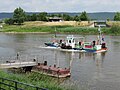
Weser ferry "Amanda" between the Great Weserbogen and Bad Oeynhausen

Weser ferry "Amanda"
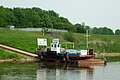
Ferry out of service due to low water (May 2011). Two drive propellers can be seen .
Crossing from Rehme to the Great Weserbogen


Individual evidence
- ↑ Rainer Pape: Charming Werretal: between Teutoburg Forest and Porta Westfalica . Heka-Verlag, Leopoldshöhe 1995, ISBN 3-928700-15-4 , p. 10 .
- ↑ Source: Display boards on the Kaiser Wilhelm monument at Porta Westfalica . See file: Porta Westfalica, 2009-Nov 147.jpg , file: Porta Westfalica, 2009-Nov 149.jpg and file: Porta Westfalica, 2009-Nov 150.jpg
Web links
Coordinates: 52 ° 13 ′ 19 ″ N , 8 ° 50 ′ 16 ″ E