
Great Sea (Südbrookmerland)
| Big sea | ||
|---|---|---|

|
||
| Great Sea, July 2006 | ||
| Geographical location | Südbrookmerland , East Frisia | |
| Tributaries | various | |
| Drain | Heikeschloot → Small Sea ; Knockest low | |
| Places on the shore | Bedekaspel | |
| Location close to the shore | Emden , Aurich | |
| Data | ||
| Coordinates | 53 ° 25 '51 " N , 7 ° 17' 40" E | |
|
||
| Depth below sea level | 1.4 m below sea level | |
| surface | 2.89 km² | |
| Middle deep | 1 m | |
|
particularities |
Niedermoorsee |
|

The Great Sea is a naturally formed low moor lake and lies between Aurich and Emden near Bedekaspel in Südbrookmerland , on the edge of the East Frisian Geest in the transition to the Ems marsch . The lake is the fourth largest lake in Lower Saxony with a free water area of around 289 hectares (with reed silting zones approx. 400 hectares) . The Great Sea is - apart from a few deeper places - only 0.5 to 1.0 meters deep. It is divided into two almost separate bodies of water (north and south part). A special feature is that the mean water level is 1.4 meters below sea level ( NN ) due to artificial drainage .
history
The nature reserve " southern Big Sea " was recorded in 1974 and is powered by a 2,500-hectare conservation area surrounded. The northern part, on the other hand, is used as a leisure and recreation area and offers space for fishing and water sports . However, the Great Sea may not be navigated with internal combustion engine boats, but the surrounding canals may, whereby a speed of 5 km / h (walking pace) must not be exceeded to protect bank reinforcements, bank vegetation and grounds.
In April 2008 the new 3-Meere-Weg was inaugurated. A circular route along the 3 seas: Big Sea, Small Sea and Loppersumer Meer , which is not only a tourist attraction due to the crossing with so-called Pünten , but also to better connect the places: Bedekaspel and Bedekaspeler Marsch and to promote the experience and understanding of nature . There are two routes, one about 15 km and one about 30 km in length.
Between 2009 and 2012 four weirs were built at the inflows and outflows of the Great Sea, with which the water level can be raised to 1.1 m below sea level. The objectives of the measure were better flood protection and more natural water level dynamics. The weirs are only used in winter for a maximum of 14 days.
With its extensive reed / reed belt and the adjacent wet grassland , the Great Sea and its surroundings are breeding and habitat of supra-regional importance. Godwit , snipe , lapwing , Short-eared owl , marsh harrier , hen harrier , bittern , sedge warbler , Bluethroat and Reed Bunting are some of the value-determining for conservation breeding bird species. In winter, gray geese and white-fronted geese rest here in huge flocks. Dogs must be kept on a leash during the breeding and setting season (April 1st to July 15th).
Southwest of the Great Sea is the Little Sea , also known as the "Hieve". To the west of the northern part of the Great Sea is the Loppersumer Meer . The former "Siersmeer" and the "Heerenmeeder Meer" (?) In the southern part of the nature reserve are completely silted up and show the stage of a Großseggenrieds with transitions to the gray willow bushes.
Picture gallery

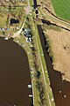
Small Sea (front) and Big Sea (back) from the air, May 2013

At the Great Sea, September 2010
Boat moorings on the northern edge of the Great Sea, May 2013

Silting zone on the shores of the Great Sea, July 2011

Aerial view of the reed zones on the Great Sea, May 2013


See also
Web links
- Big sea: plans for meadow bird project are on the table. Aurich district leads the planning approval procedure for NLWKN projects. May 21, 2015, accessed June 25, 2015 .
- Big Sea project
- Origin and importance of the Great Sea
Individual evidence
- ↑ A new water management for the Great Sea at www.projekt-grosses-meer.de (accessed on August 18, 2016).