Great Fiescherhorn
| Great Fiescherhorn | ||
|---|---|---|
|
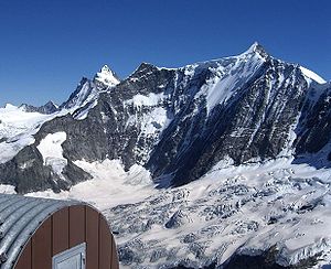
The Grosse Fiescherhorn from the Mittellegihütte , to the left of it Ochs and to the left behind the Finsteraarhorn |
||
| height | 4048.8 m above sea level M. | |
| location | Border canton Bern / canton Wallis , Switzerland | |
| Mountains | Bernese Alps | |
| Dominance | 4.8 km → Mönch | |
| Notch height | 398 m ↓ Fieschergrat | |
| Coordinates | 647 768 / 155752 | |
|
|
||
| First ascent | July 23, 1862 by H. B. George, Christian Almer , Ulrich Kaufmann , Adolphus Warburton Moore | |
| Normal way | South-east ridge from the Fieschersattel ( 3923 m above sea level ) (II) | |
The Grosse Fiescherhorn , also called Gross Fiescherhorn in older literature , is 4049 m above sea level. M. the highest peak of the three Fiescherhorns in the Bernese Alps . The mountain sends out pronounced ridges to the northwest, east and southeast; The border between the Swiss cantons of Bern in the north and Valais in the south runs along the west-east running main ridge . To the north, a 1250 meter high and about 4 kilometer long wall, the Fiescherwand , falls down into the rugged Ischmeer glacier . Due to its extraordinary height and easy accessibility in the middle of the Bernese Alps, the Horn is an important panoramic mountain that is often climbed in late winter as part of ski tours . First the Grosse Fiescherhorn was climbed on July 23, 1862 by H. B. George, Christian Almer , Ulrich Kaufmann and Adolphus Warburton Moore over the southwest ridge.
Fiescherhörner summit
- Grosses Fiescherhorn (4049 m)
- Rear Fiescherhorn (4025 m)
- Small Fiescherhorn, also called Ochs (3895 m)
Location and surroundings
The area around the Fiescherhörner is completely surrounded by glaciers. The Ischmeer extends to the north, the Valais Fiescherfirn to the east and the Ewigschneefäld to the south and west . Neighboring mountains are located in the west, separated by the Unders Mönschsjoch , at 3523 meters, the 4107-meter-high Mönch , directly adjacent to the east in the ridge course of the Ochs or the Kleine Fiescherhorn, in the south, separated by the Fieschersattel (3923 m) Behind Fiescherhorn and further on, the Kleines and Grosses Grünhorn at 3913 and 4044 meters above sea level. The nearest significant place in the north is Grindelwald, about 8 kilometers away as the crow flies .
Alpinism
The route of the first climber in 1862 over the south-west ridge is uncommon today. All routes on the Grosse Fiescherhorn are serious high-altitude tours that can only be climbed with appropriate equipment and experience. Today's normal route (the slightest ascent) leads from Fieschersattel over the southeast ridge, which was first walked in 1871 . Suitable bases for this route are the Finsteraarhornhütte in the south-east at 3,048 meters (walking time from here 5½ hours over the Walliser Fiescherfirn), the Konkordiahütte in the south at 2,850m and the Mönchsjochhütte (3,627m) in the west, each with up to six Hours of walking. The climbs are given in the literature with the difficulties WS to WS + (route over Fieschersattel and southeast ridge) or ZS (route over the north-west ridge inclined up to 50 °) in the SAC mountain and alpine tour scale. All routes through the northern Fiescherwand are extremely difficult , as they also pose a great risk of ice and rockfall.
Literature and map
- Swiss Alpine Club (Ed.): Bernese Alps. Volume 4: Karl Hausmann: Tschingelhorn to Finsteraarhorn. SAC, Bern 1997, ISBN 3-85902-162-1 .
- Richard Goedeke : 3000 meters in the northern Alps. The normal routes - from the Bernese Oberland over the main Alpine ridge to the Hohe Tauern. Bruckmann, Munich 2004, ISBN 3-7654-3930-4 .
- Werner Munter , Margrit Munter: Bernese Alps. Area guide for hikers, mountaineers and climbers. From the Sanetsch Pass to the Grimsel. The most popular climbs to the most important peaks with a description of all recommended ski mountaineering tours. Written according to the guidelines of the UIAA. 10th, revised edition. Bergverlag Rother, Munich 1995, ISBN 3-7633-2415-1 .
- National map of Switzerland 1: 25,000, sheet 1249, Finsteraarhorn
Web links
- Grosses Fiescherhorn at 4000m - the four-thousanders of the Alps


