Schauinsland mine
| Schauinsland mine | |||
|---|---|---|---|
| General information about the mine | |||
| other names | Ore box | ||
| Information about the mining company | |||
| Start of operation | 13th century | ||
| End of operation | 1954 | ||
| Successor use | Visitor mine | ||
| Funded raw materials | |||
| Degradation of | Silver / lead / zinc | ||
| Greatest depth | 900 m | ||
| Geographical location | |||
| Coordinates | 47 ° 54 '34.8 " N , 7 ° 53' 54.7" E | ||
|
|||
| local community | Oberried | ||
| District ( NUTS3 ) | Breisgau-Upper Black Forest | ||
| country | State of Baden-Württemberg | ||
| Country | Germany | ||
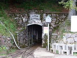
The Schauinsland mine (or ore box in the 19th century ) was a silver and lead mine east of Freiburg im Breisgau ; zinc ore was also mined from the 19th century . The mining lasted from the 13th century until 1954, and the Schauinsland pit has been a visitor mine since 1997.
geology
The pit is located in the south-central Black Forest , directly south of the 1284 m high summit Schauinsland . There are numerous corridors that dip very steeply to the west and largely run parallel to the Upper Rhine Graben. The veins consist of quartz - barite - carbonate and contain minable quantities of zinc blende and galena . The side rocks are gneiss and anatexite . The minable main corridors are located in an area 1.7 km wide and 3.4 km high in the vicinity of the Schauinsland summit. It was mined down to a depth of 900 m .
history
13th century to 17th century: Late Middle Ages
Mining on the Schauinsland began at the latest in the early 13th century with the construction of the mining settlement Dieselmuot, southwest of Hofsgrund near the Haldenhof . The lavishly designed church windows in Freiburg Minster from the 14th century on the subject of mining on the Schauinsland testify to a first high point in mining . One of the oldest mountain orders in Europe, the Dieselmuoter Bergweiseum , dates from 1372. It regulated mining in the Schauinsland region under Count Egino III. from Freiburg , all those involved were brought together at the Haldenhof. In the 15th century, mining was cut back sharply, mainly due to the lack of wood caused by overexploitation and disputes with the Oberried monastery as the landowner. With the onset of the Thirty Years' War from 1618 and Pest - epidemics of mining came in the region largely to a complete standstill.
17th century to 20th century: modern times
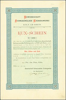
After the turmoil of the war, systematic mining did not begin again until 1724. During this time, mainly green lead ore and galena were mined on the Schauinsland and smelted on site . From the 18th century the economic interest in lead awoke, which led to a strong demand. The years 1744 to 1794 showed a noticeable upswing, mining was preferred on the Barbara and Gsprenggang. However, the heyday ended around the turn of the century, from 1803 it was reported that 19 tunnels are known in the region, but none are accessible anymore. Mining stopped until 1876. Then Carl von Roggenbach began to expand again. From 1891, the Black Forest ore mines founded in Cologne took over the exploitation of the deposit. For the next 30 years, mining was carried out intensively, and from 1923 the mining rights were transferred to the Bergbau-AG Lothringen . The falling world market prices for lead and zinc led to the mine being closed in 1930 during the Weimar Republic .
Only a few years later, from 1935, mining operations were resumed, this time by Stolberger Zink AG. From 1945 to 1946 there was a business interruption, from October 31, 1954, the business finally had to be shut down for good, reduced profitability and falling world market prices forced the closure.
1997 until today: visitor mine
The first initiative to preserve the mine was started as early as 1976, the Steiber research group. In over 20 years, 30 km of routes have been covered and made accessible. From 1997 onwards the visitor business could start. The Schauinsland visitor mine is one of the largest show mines in Germany.
Pit field
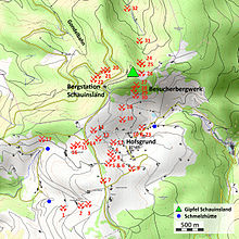
The mining field on the Schauinsland included 32 shafts and tunnel mouth holes. The visitor mine is located 700 m east of the mountain station of the Schauinsland cable car at No. 28 (Gegentrumstollen II).
| No. | Surname | No. | Surname |
|---|---|---|---|
| 1 layer | Lowest Willnau tunnel | 17 location | Farnacker tunnel |
| 2 position | Lower Willnau tunnel | 18 position | Schanzenstollen |
| 3 position | Upper Willnau tunnel | 19 location | Rotlache, southern tunnel |
| 4 position | Lower Barbarastollen | 20 position | Ramselendobelstollen IV |
| 5 position | Upper Barbarastollen | 21 position | Ramselendobelstollen IV |
| 6 position | Barbara open pit | 22 location | Ramselendobelstollen IV |
| 7 location | Shafts to the heap | 23 location | Hofsgrund gallery |
| 8 position | Shafts below Poche | 24 location | Ore box tunnel I |
| 9 location | Bühlhof tunnel | 25 position | Ore box gallery II |
| 10 location | Erbstollen Grube Barbara | 26 location | Ore box gallery III |
| 11 location | Lower Gpsrenggangstollen | 27 location | Counter-center stud I |
| 12 location | Middle Gpsrenggang tunnel | 28 location | Counter-center tunnel II |
| 13 position | Upper Gpsrenggangstollen | 29 location | Counter-center tunnel III |
| 14 location | Day shaft at the pond | 30 position | Counter-center tunnel IV |
| 15 location | Upper shingle matt tunnel | 31 location | Kappler's tunnel |
| 16 position | Lower shingle matt tunnel | 32 location | Leopold tunnel |
literature
- Wolfgang Werner, Volker Dennert: Deposits and mining in the Black Forest. Published by the State Office for Geology, Raw Materials and Mining, Baden-Württemberg. Freiburg im Breisgau 2004, ISBN 3-00-014636-9 .
- Martin Straßburger: Mining in the Schauinsland from the late Middle Ages to around 1800. In: Journal for Archeology of the Middle Ages. Vol. 31, 2003, pp. 212-213.
- Martin Straßburger: Mining in the Schauinsland from the late Middle Ages to around 1800 . Proceedings of the 7th International Mining Workshop 2004 Clausthal-Zellerfeld. St. Andreasberg / Clausthal-Zellerfeld 2004, pp. 105-109.
- Martin Straßburger: Mining in the Schauinsland from the late Middle Ages to around 1800. In: Schau-ins-Land. 126th year booklet, 2007, pp. 69–88.
- Martin Straßburger: Mining archeology and economic history of mining in the Schauinsland from the 13th century to around 1800 . (= University research on prehistoric archeology. Volume 275). Publishing house Dr. Rudolf Habelt, Bonn 2015, ISBN 978-3-7749-3969-1 .
- Martin Straßburger: Mining in the Schauinsland from the late Middle Ages until about 1800. In: Jacquo Silvertant (Hrsg.): Echoes of a Mining Past. Yearbook of the Institute Europa Subterranea 2018. Silvertant Erfgoedprojecten, Kelmis / Gulpen 2018, ISBN 978-90-823515-9-0 , pp. 35–85.
Individual evidence
- ↑ Wolfgang Werner, Volker Dennert: Deposits and mining in the Black Forest. 2004, p. 248 ff.
- ↑ G. Albiez: The mining at the Schauinsland. Freiburg im Breisgau 1964, pp. 115-120.
- ↑ Wolfgang Werner, Volker Dennert: Deposits and mining in the Black Forest. 21004, p. 253 ff.
- ↑ Wolfgang Werner, Volker Dennert: Deposits and mining in the Black Forest. 2004, p. 252 ff.
- ↑ B. Steiber: The Schauinsland. History. Geology. Minerals. Haltern (Bode) 1986, ISBN 3-925094-08-3 .
- ↑ B. Steiber: The Schauinsland mine and the Steiber research group. In: Freiburg Almanach, Illustrated Yearbook. Freiburg im Breisgau 2000, pp. 107–118.
- ↑ Wolfgang Werner, Volker Dennert: Deposits and mining in the Black Forest. 2004, p. 255 ff.
- ↑ Burkhardt Jürgens: The treasure in the Silberberg. In: Frankfurter Allgemeine Zeitung. March 31, 1999.
Web links
See also
- List of show mines
- Barbarastollen Schauinsland
Use this list offline
For mobile and offline use of all coordinates on this page, the corresponding KML file or. the GPX file for download to the smartphone under the following links:


