
Vychylovka Forest Railway
| Vychylovka Forest Railway | |||||||||||||||||||||||||||||||||||||||||||||||||||||||||||||||||||||||||||||||||||||||||||||||||||||||||||||||||||||||||||||||||
|---|---|---|---|---|---|---|---|---|---|---|---|---|---|---|---|---|---|---|---|---|---|---|---|---|---|---|---|---|---|---|---|---|---|---|---|---|---|---|---|---|---|---|---|---|---|---|---|---|---|---|---|---|---|---|---|---|---|---|---|---|---|---|---|---|---|---|---|---|---|---|---|---|---|---|---|---|---|---|---|---|---|---|---|---|---|---|---|---|---|---|---|---|---|---|---|---|---|---|---|---|---|---|---|---|---|---|---|---|---|---|---|---|---|---|---|---|---|---|---|---|---|---|---|---|---|---|---|---|---|
 | |||||||||||||||||||||||||||||||||||||||||||||||||||||||||||||||||||||||||||||||||||||||||||||||||||||||||||||||||||||||||||||||||
| Course book series (ZSSK) : | 910 (417) | ||||||||||||||||||||||||||||||||||||||||||||||||||||||||||||||||||||||||||||||||||||||||||||||||||||||||||||||||||||||||||||||||
| Route length: | 29.024 km | ||||||||||||||||||||||||||||||||||||||||||||||||||||||||||||||||||||||||||||||||||||||||||||||||||||||||||||||||||||||||||||||||
| Gauge : | 760 mm ( Bosnian gauge ) | ||||||||||||||||||||||||||||||||||||||||||||||||||||||||||||||||||||||||||||||||||||||||||||||||||||||||||||||||||||||||||||||||
| Maximum slope : | 73 ‰ | ||||||||||||||||||||||||||||||||||||||||||||||||||||||||||||||||||||||||||||||||||||||||||||||||||||||||||||||||||||||||||||||||
| Minimum radius : | 40 m | ||||||||||||||||||||||||||||||||||||||||||||||||||||||||||||||||||||||||||||||||||||||||||||||||||||||||||||||||||||||||||||||||
| Top speed: | 8 km / h | ||||||||||||||||||||||||||||||||||||||||||||||||||||||||||||||||||||||||||||||||||||||||||||||||||||||||||||||||||||||||||||||||
|
|||||||||||||||||||||||||||||||||||||||||||||||||||||||||||||||||||||||||||||||||||||||||||||||||||||||||||||||||||||||||||||||||

The forest railway Vychylovka (Slovak Historická lesná úvraťová železnica Vychylovka (HLÚŽ) ) is a Slovak forest railway with the track width of 760 mm. The route is located in northern Slovakia on the border with Poland and leads through the mountains of the Slovak Beskids . It used to be more branched and had a total length of 61 km. Today the route is used for tourist purposes over a length of about 5 kilometers. Overcoming the height difference of 217 meters was made possible by switchbacks .
Economical operation
Supported by the industrial development in what is now Slovakia, the demand for wood increased sharply in the 19th century. The Orava region was a source of this raw material . At the same time, this branch of industry represented one of the few sources of income in this region. Due to the poor infrastructure , however, only a few forests in the region could be used for forestry purposes. Tree trunks felled in harder-to-reach forests could only be removed by rafting or horse-drawn carts . These modes of transport could no longer cope with the increasing demand. The construction of forest railways thus represented an alternative. These railways were not dependent on weather conditions, which had a considerable influence on rafting and on the paths. The difficult topography of the region called for a narrow-gauge railway, as this made it possible to reduce the required curve radii . At the same time, the region's long valleys were predestined for the construction of forest railways.
The routes of the forest railway were built between 1915 and 1918. The route network was created by merging two separate rail networks, the Kysuce forest railways from Oščadnica to Chmúra and Orava from Lokca to Erdútka , in 1926.
Kysuce Forest Railway
The forest railway Kysuce (Slovak: Kysucká lesná železnica (KLŽ) ) got the concession to build a forest railway from Krásno nad Kysucou to Nová Bystrica in 1906. This line was never completed. In 1914, the private Viennese stock corporation bought the felling rights in the Bystrica river valley from Count Karolyi for a period of 10 years. On December 17, 1914, a public survey was held about the construction of a narrow-gauge line from Oščadnica through the Bystrica valley to Chmúra. The building permit for the line was granted on May 12, 1915. On July 7, 1917, the operating permit for operation on the route from Oščadnica to Stará Bystrica (about 16 kilometers) was issued. On March 15, 1918, the concession for the next section from Stará Bystrica to Nová Bystrica was granted. From October 15, 1918, a temporary operating permit for the section to Vychylovka and Harveľka was issued.
Orava Forest Railway
The Orava Forest Railway ( Oravská lesná železnica (OLŽ) in Slovak ) received an operating license on July 27, 1918 for the section of the route built from April 1914. This was built mainly by Italian prisoners from the First World War . It had a length of 23 km. Including turning systems and junctions, the total length was 41 km.
Association of KLŽ and OLŽ
The merger took place due to the poor connection of the Orava forest railway to the standard gauge network . Until then, the felled tree trunks had to be brought over the Príslop mountain saddle by road or rafted across the Biela Orava river . The forest railway Kysuce, however, had a connection to the standard gauge network via a siding .
| Transport quantities | Wood in m³ |
|---|---|
| 1927 | 142.121 |
| 1956 | 160,000 |
| 1961 | 83,531 |
| 1966 | 53,407 |
During the construction of the 10.5 km long connecting road, a height difference of 217 meters had to be overcome over a distance of 1.5 km. In the difficult terrain, this was only possible by using five switchbacks. The main network of the forest railway was 61 kilometers. Including all branch lines, the network had a total length of 110 kilometers.
The line was in operation until 1969.
Museum operation since 1972
The elevation of the railway line to a technical cultural monument in 1972 came at the last minute. This saved around 8 km of the 110 km long network from being dismantled. The 8 remaining kilometers included the route from Vychylovka (district of Nová Bystrica ) to the Chmúra station, as well as the section with the technically unique switchbacks in Europe. Almost all of the existing rolling stock had been sold.
In 1974 the Kysuce Museum in Čadca took over the railway site with the intention of building an open-air museum with buildings typical of the region next to the railway line . The open-air museum was founded, on the one hand to show the railway line and its operation as an authentic object of the production, transport and technical history of the wood industry , and on the other hand to present the history of the population of the region. For this purpose, 2.7 kilometers of the dismantled route were rebuilt between 1977 and 1981. Rail material from other forest railways in Slovakia could be used here. At this time, efforts were made to expand the greatly reduced fleet of vehicles by purchasing other forest railways . In the 1980s, with the help of many volunteers who repaired the route, the first test drives could be undertaken. On June 26, 1988, however, the engine shed at Skanzen station burned down. This fire caused irreparable damage to the vehicles parked in the shed.
With the status of the National Cultural Monument, which was granted at the beginning of 1990, there was a renaissance of the railway line. In 1991 - with the application for inclusion in the UNESCO World Heritage Site - the railway was renamed the " Historical Switchback Forest Railway" (Slovak: Historická lesná úvratová železnica ). In August 1992 an agreement was signed between the Orava Museum in Dolný Kubín and the Kysuce Museum in Čadca on the renovation of the preserved part of the forest railway in both regions (Orava and Kysuce). In 1995 the burned down engine shed was rebuilt. Between 1992 and 1995, the line between Kubátkovia, Chmúra and Beskyd was made operational. A rock fall in the first hairpin set the project back, so that tourist traffic can currently only be offered on part of the route:
- from Kubátkovia through the open-air museum to the first hairpin ("Historická lesná úvratová železnica", length 3.4 km). In the summer of 2010, however, the section west of the open-air museum (Kubátkovia - St. Skanzen) was not in operation due to flood damage.
- In the section St. Skanzen - Sattel Beskyd with a motorized trolley
- in the Tanecník - Beskyd Saddle section as "Oravská lesná železnica" (opened in May 2008).
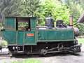
Vehicle fleet
working steam locomotives :
literature
- Cultural Heritage of Slovakia, Technical Monuments, ISBN 978-80-89226-44-3
photos

U 34.901
U 45.9

HLÚŽ DH 120
Chmúra


Individual evidence
- ↑ Archived copy ( Memento of the original from March 10, 2007 in the Internet Archive ) Info: The archive link was inserted automatically and has not yet been checked. Please check the original and archive link according to the instructions and then remove this notice.
- ↑ Archived copy ( Memento of the original from March 10, 2007 in the Internet Archive ) Info: The archive link was inserted automatically and has not yet been checked. Please check the original and archive link according to the instructions and then remove this notice.
- ↑ Cultural Heritage of Slovakia, Technical Monuments, page 75
Web links
- Vychylovka Forest Railway
- Museum homepage (sk)
- Vychylovka Forest Railway (en / sk)
- Information on rail.sk (sk)
- Video of a trolley ride :
Coordinates: 49 ° 22 ′ 57 ″ N , 19 ° 6 ′ 0 ″ E