
Hackås
| Hackås | ||||||
|
||||||
| State : | Sweden | |||||
| Province (län): | Jämtland County | |||||
| Historical Province (landskap): | Jämtland | |||||
| Municipality : | mountain | |||||
| Coordinates : | 62 ° 56 ' N , 14 ° 31' E | |||||
| SCB code : | 7848 | |||||
| Status: | Crime scene | |||||
| Residents : | 531 (December 31, 2015) | |||||
| Area : | 1.42 km² | |||||
| Population density : | 374 inhabitants / km² | |||||
| Height : | 326 m above sea level | |||||
| List of perpetrators in Jämtland County | ||||||

Hackås is a locality ( tätort ) in the mountain community in southern Jämtland . The place is located between a foothill of the Storsjön and Lake Näkten about 30 km south of Östersund and is an old railway junction of the Inland Railway .
The name is first recorded as Hakaas in 1391 and is made up of haka for outstanding country part and ås for mountain range. This probably means the area around the two villages of Hov and Fäste north of the church, where a deep valley delimits this area in the north and east .
Hackås is located at the transition between two parts of Storsjös 0150, Sannsundet in the north and Södra Storsjöflaket in the south. Hackås ångbåtsbrygga , a steamboat bridge with steamboat traffic , is on the beach . There is also a 3 km long ferry route between the village and Funäs .
Picture gallery

Location of Håckas
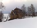
Hackås Church
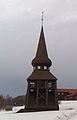
The bell tower of the church


Individual evidence
- ↑ a b Statistiska centralbyrån : Land area per Tatort, folkmängd and invånare per square kilometer. Vart femte år 1960 - 2015 (database query)
- ↑ Svenskt local dictionary . Språk- och folkminnesinstitutet (SOFI), Uppsala, 2003. p. 104. ISBN 91-7229-020-X