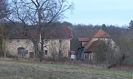
Hebendorf
|
Hebendorf
Rentweinsdorf market
Coordinates: 50 ° 4 ′ 2 ″ N , 10 ° 50 ′ 2 ″ E
|
|
|---|---|
| Height : | 325 m above sea level NHN |
| Residents : | 4 (2014) |
| Postal code : | 96184 |
| Area code : | 09531 |
|
The Rentweinsdorfer district Hebendorf
|
|
Hebendorf is one of ten officially named districts of the Rentweinsdorf market in Lower Franconia .
geography
The wasteland is located about two and a half kilometers east-northeast of Rentweinsdorf at an altitude of 325 m above sea level. NHN . It is located on a high plateau on a ridge of the Hassberge and about 70 meters above the valleys of the Baunach flowing to the west and the Itz to the east.
history
Thanks to its wide view over the valleys, the exposed altitude was already the site of a tower hill castle in the Middle Ages , the remains of which are protected as a ground monument. The hilltop castle took up an area of about 5000 m² and to the south of it there were two farms. The first mention was in 1444.
In 1805 Hebendorf had 18 souls. The Bavarian cadastre shows Hebendorf in the 1810s with two hearths and a pond , which, as a heavenly pond , draws its water from precipitation and groundwater inflows. Excess water flows in a stream to the west and towards the Baunach at Treinfeld.
As a result of the administrative reforms carried out in the Kingdom of Bavaria at the beginning of the 19th century , the place became part of the independent rural community Treinfeld , to which the wasteland Treinfeldsmühle also belonged. In 1900 the place had 18 and 1950 31 inhabitants.
In the course of the municipal territorial reform in Bavaria carried out in the 1970s , Hebendorf was incorporated into the Rentweinsdorf market together with the entire municipality of Treinfeld on January 1, 1978. In 2014 Hebendorf had four residents. Only the eastern of the two courtyards and the pond are still preserved. The western courtyard was torn down and leveled, the former location of the castle is marked by a mighty tree, which is a natural monument . In 2010, the largest solar park in the Haßberge district was built on the former agricultural land to the northwest of the town . 13 million kWh are generated there annually on 48 hectares , electricity for 3700 households.
traffic
The connection to the public road network is made by an unpaved dirt road that begins in Treinfeld, about one and a half kilometers away. At the southern edge of this place, the Rentweinsdorf stop on the Breitengüßbach – Ebern railway line is also the closest train station.
Web links
- Hebendorf in the BayernAtlas (accessed on October 23, 2018)
- Hebendorf on a historical map (accessed on October 23, 2018)
Individual evidence
- ↑ Population of Hebendorf on the Rentweinsdorf website (accessed on October 23, 2018)
- ↑ lifting village in the location database of the Bavarian State Library Online . Bavarian State Library, accessed on October 23, 2018.
- ↑ Geographical location of Hebendorf in the BayernAtlas (accessed on October 23, 2018)
- ↑ LfD list for Rentweinsdorf (.pdf)
- ^ Werner Schmiedel: Districts Ebern and Hofheim. In: Historical book of place names of Bavaria. Lower Franconia. Volume 2: Districts of Ebern and Hofheim. Commission for Bavarian State History, Munich 1973, ISBN 3-7696-9872-X , p. 113.
- ↑ Population 1805
- ↑ lifting village on Bayern Atlas Classical
- ↑ Composition of the rural community Treinfeld (accessed on October 23, 2018)
- ↑ K. Bayer. Statistical Bureau (Ed.): Directory of localities of the Kingdom of Bavaria, with alphabetical register of places . LXV. Issue of the contributions to the statistics of the Kingdom of Bavaria. Munich 1904, Section II, Sp. 1310 . ( Digitized version ).
- ↑ Bavarian State Statistical Office (ed.): Official place directory for Bavaria - edited on the basis of the census of September 13, 1950 . Issue 169 of the articles on Bavaria's statistics. Munich 1952, DNB 453660975 , Section II, Sp. 1178 . ( Digitized version ).
- ↑ Statistisches Bundesamt Wiesbaden (Ed.): Historical municipality register for the Federal Republic of Germany (1970-1982) . W. Kohlhammer GmbH, Stuttgart and Mainz 1983, ISBN 3-17-003263-1 , p. 760 .
- ↑ Luftbild, ND, Weiher
- ↑ Solar Park Lift village


