
Heidenbach (Werre)
| Heidenbach | ||
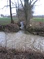
 The Heidenbach upper course |
||
| Data | ||
| location | North Rhine-Westphalia , Germany | |
| River system | Weser | |
| Drain over | Werre → Weser → North Sea | |
| source | approx. 2 km south of Detmold - Hiddesen | |
| Source height | approx. 235 m above sea level NN | |
| muzzle | At Detmold-Mühlenbruch in the Werre Coordinates: 51 ° 57 ′ 16 ″ N , 8 ° 50 ′ 45 ″ E 51 ° 57 ′ 16 ″ N , 8 ° 50 ′ 45 ″ E |
|
| Mouth height | approx. 120 m above sea level NN | |
| Height difference | approx. 115 m | |
| Bottom slope | approx. 17 ‰ | |
| length | 6.6 km | |
| Catchment area | 8.752 km² | |
The Heidenbach is a 6.6 km long orographic left tributary of the Werre in the Lippe district in East Westphalia-Lippe , Germany .
course
The Heidenbach rises at about 235 m above sea level. NN in a deeply cut valley , which is limited by the 393 m high Bielstein in the west, the 386 m high Grotenburg in the east, and by the 393.4 m high Klöppingsberg in the south. The Heidenbach flows from its source through the Heidental towards the south, flows through Hiddesen and Heidenoldendorf and finally flows north of Heidenoldendorf near Mühlenbruch into the Werre . From Heidenoldendorf the stream was channeled for its last one and a half kilometers to its mouth and in Heidenoldendorf was forced into a concrete bed over a length of 400 meters. The stream overcomes a total difference in height of 115 meters, which corresponds to a mean bed gradient of 1.8 percent.
In the German basemap , another source is shown as the source of the Heidenbach. This is located to the northeast of the source identified by the State Surveying Office of North Rhine-Westphalia on the southern slope of the Grotenburg. If you take this as the origin of the water, the total length is 7.0 km.
Tourism / leisure
In the Heidental there are a number of marked hiking trails , including the Hermannsweg , which leads from the Heidental up to the Hermannsdenkmal on the Grotenburg .
environment
The Heidenbach is assigned to water quality class II. This means that it is moderately dirty.
particularities
The Heidenbach rises on the northern flank of the Teutoburg Forest , which is part of the Weser-Ems watershed . This is why its water flows over the Werre to the Weser , while waters that arise a few kilometers further south flow into the Ems . The Heidenbach has no notable and named tributaries. After long periods of dryness, especially in summer, the Heidenbach falls dry over long stretches.
photos
The Heidenbach flows into the Werre

The dried up Heidenbach in the upper reaches

Artificially created waterfall of the Heidenbach


See also
Individual evidence
- ↑ a b Topographic map 1: 25,000
- ↑ a b Topographical Information Management, Cologne District Government, Department GEObasis NRW
- ↑ Water quality map district Lippe 2008