
Heining (running)
|
Heining
City of Laufen (Salzach)
Coordinates: 47 ° 55 ′ 10 ″ N , 12 ° 55 ′ 21 ″ E
|
|
|---|---|
| Height : | 460 m above sea level NN |
| Incorporation : | January 1, 1970 |
| Postal code : | 83410 |
| Area code : | 08682 |
Heining is a district of the city of Laufen in the Upper Bavarian district of Berchtesgadener Land and was an independent municipality in what was then the district of Laufen until January 1, 1970 .
geography
The community was in the eastern Rupertiwinkel at an altitude of about 405 to 470 m above sea level. NN . The area is characterized by post-glacial gravel soils that the Salzach , which flows to the east near the local area, brought in as debris when the Salzach glacier melted. To the south of the former municipal area lies the Abtsdorfer See , which is located in an excavation hollow of the glacier and was also formed after the Ice Age.

Districts
Abtsee, Arzenpoint, Daring, Fisching, Gastag, Haiden, Kletzling, Lepperding, Moosham, Niederheining, Oberhaslach, Oberheining, Seebad, Seethal, Steinbach, Thannberg, Thannhausen, Unterhaslach, Wiedmannsfelden
history
The area was already visited by people in the Copper Age, as individual reading finds show. At the time of the Celts , the Salzach became an important trade route for the long-distance salt trade that gave it its name . Between Niederheining and Daring there are burial mounds with burials from the Hallstatt period and the Roman Empire . First documentary mentions date from the Carolingian period and the village settlements originated in the Salian period . Until the 18th century, the usual spelling of the place name was Haining (see map). Only after the Bavarian municipal edict did the Heining , which is used today, become established.
The Bavarian cadastre shows Heining in the 1810s as a hamlet with seven courtyards and a pond to the west.
In 1970 it was incorporated into the city of Laufen . Numerous architectural and ground monuments have been preserved in the districts.
Attractions
church
The church in Niederheining was first mentioned in 788/790. Today's Catholic Church of St. Laurentius in Niederheining (branch church of the parish of Laufen) was probably built at the end of the 15th century and built over the underground remains of the previous building. The church bell is dated 1491. In 1666 the nave was extended to the west and in 17/18. The churchyard wall was added in the 19th century.

St. Laurentius (2016) View from the East

Landscape near Daring

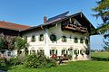
Farmhouse in Daring

St. Mary in Daring

Niederheining wayside cross
Farmhouse in Arzenpoint

Farmhouse in Niederheining

Resettlement farm near Haiden

.jpg)
.jpg)
.jpg)
.jpg)


Individual evidence
- ^ Reindel-Schedl, Helga: Historical Atlas of Bavaria, running on the Salzach . S. 761 f .
- ↑ a b c LfD list for Laufen (Heining), pages 11, 12 and 23 (.pdf)
- ↑ Historical map of Oberheining in the BayernAtlas
- ^ Roth, Hans: The branch churches of the parish Laufen . In: Laufen and Oberndorf, 1250 years of history ... p. 383 ff .