
Heppenser Groden
|
Heppenser Groden
City of Wilhelmshaven
Coordinates: 53 ° 32 ′ 41 ″ N , 8 ° 8 ′ 43 ″ E
|
|
|---|---|
| Area : | 6.44 km² |
| Residents : | 746 (2008) |
| Population density : | 116 inhabitants / km² |
| Area code : | 04421 |
 Location of the Heppenser Groden in Wilhelmshaven
|
|

The Heppenser Groden is a district of Wilhelmshaven . The district is characterized by the naval base Heppenser Groden and the tank farm of the Nord-West Oelleitung (NWO); there are also agricultural areas and a commercial area. On the other hand, there is no residential development, the number of inhabitants results almost exclusively from the naval base.
geography
The district borders on the west on Friesendamm on the districts of Heppens and Neuengroden , on the north on the street Am Maadesiel on the Rüstersieler Groden , in the east on the Jade Bay and in the south below the sea lock on the inner harbor. The dike of the Groden began in 1938.
Views

Aerial view with sea lock, naval base and tank farm.

Oil tankers at the pier
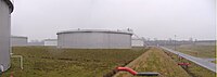
Tank farm of the NWO
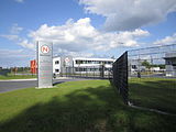
Headquarters of the Nietiedt Group
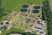
Sewage treatment plant

Jade slaughterhouse


Web links
Aldenburg | Altengroden | Bant | Ebkeriege | Fedderwarden | Fedderwardergroden | Heppens | Heppenser Groden | Kingdom of Heaven / Coldewei | Inner Harbor | Downtown | JadeWeserPort | Langewerth | Maadebogen | New end | Neuengroden | Rustersiel | Rustersieler Groden | Rüstringer City Park | Schaar | Sengwarden | Siebethsburg | Voslapp | Voslapper Groden