Ebkeriege
|
Ebkeriege
City of Wilhelmshaven
Coordinates: 53 ° 31 ′ 17 ″ N , 8 ° 4 ′ 3 ″ E
|
|
|---|---|
| Area : | 3 km² |
| Residents : | 611 (Dec 31, 2007) |
| Population density : | 204 inhabitants / km² |
| Postal code : | 26389 |
| Area code : | 04421 |
|
Location of Ebkeriege in the city of Wilhelmshaven
|
|
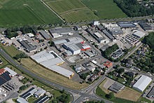
Ebkeriege is a district of the independent city of Wilhelmshaven in Lower Saxony . The district includes the Ebkeriege, Junkerei and Great Belt districts. The district is mainly characterized by its commercial operations.
location
The district is located in the southwest area of the city of Wilhelmshaven. It is bounded in the north by the federal highway B 210 (Oldenburger Strasse), in the east by the course Genossenschaftsstrasse, Güterstrasse, Ladestrasse and Banter Weg, in the south by the Oldenburg – Wilhelmshaven railway line and in the west by the city limits to the Sander district of Mariensiel . The eponymous street Ebkeriege crosses the district diagonally from southeast to northwest.
history
The name Ebkeriege goes back to an old Maadedeich between the Schaarzeile and Mariensiel, which probably already existed around 1150 and was on the south side of the former Maadebucht . First a path was built on the old dike , later the Ebkeriege road, which was one of the most important access routes to Wilhelmshaven when the Prussian jade region was settled. This dike, now the street and district name, was named after the owner of the land at the eastern end of the row, the Scheling Ebbeke or Ibbeke. As Scheling (= dike judge), he supervised the maintenance work on the dike that was incumbent on the dykes.
The name of the Junkerei district comes from a former farm on the Ebkeriege. The name Groß Belt also comes from a homestead that is still on Oldenburger Straße today.
Today the Ebkeriege is mainly characterized by the large number of commercial enterprises. In the 1980s and 1990s in particular, many commercial companies set up shop here.
Infrastructure
There are several different commercial areas in the district . In the An der Junkerei industrial park , primarily car dealerships and car technology-related businesses have settled. There are also food discounters and hardware stores in the Güterstraße / Ladestraße industrial park . The residential development is very small and is primarily located along Ebkeriege and on the east side of Genossenschaftsstraße.
The Ebkeriege military barracks of the same name are located in the Ebkeriege district . It was built during the Second World War and initially served as a workers' camp. The Ebkeriege barracks is closely linked to the history of the German Navy , as the first volunteers of the new German Navy were housed there on January 2, 1956 . As part of the restructuring of the Bundeswehr, the barracks should be closed in 2016.
After the renovation, it is currently used as quarters for soldiers working on board.
Residents
Ebkeriege had 490 inhabitants at the end of 2017, compared to 604 in 2000.
3.9% of the population are foreigners (as of 2017). The Wilhelmshaven average is 9.6%. The proportion of migrants is 16.1%, compared to an urban average of 21.8%.
Web links
Individual evidence
- ↑ Werner Brune (Ed.): Wilhelmshavener Heimatlexikon , Volume 1–3. Brune, Wilhelmshaven 1986-1987, Volume 1, page 226
- ^ Bundeswehr reform - the conversion will take another nine years , accessed on March 5, 2014
- ↑ a b City of Wilhelmshaven: Small-scale population statistics 2018. December 31, 2017, accessed on December 7, 2018 .

