Langewerth
|
Langewerth
City of Wilhelmshaven
Coordinates: 53 ° 32 ′ 11 " N , 8 ° 2 ′ 43" E
|
|
|---|---|
| Height : | 2 m above sea level NHN |
| Area : | 5.23 km² |
| Residents : | 484 (2017) |
| Population density : | 93 inhabitants / km² |
| Incorporation : | March 31, 1938 |
| Postal code : | 26389 |
| Area code : | 04421 |
|
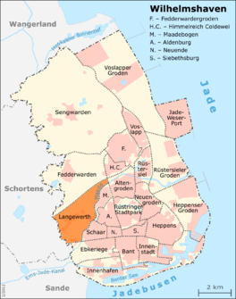
Location of Langewerth in the city of Wilhelmshaven
|
|
Langewerth is a district of the independent city of Wilhelmshaven in Lower Saxony . The district includes the districts of Langewerth and Heiligengroden.
location
The elongated district is located on the southwestern edge of the urban area and borders the Schortens district of Roffhausen in the southwest . In the north the district borders on the A 29 motorway , in the south it is bordered by the federal highway B 210 and the course of the Maade . A short stretch of Ostfriesenstrasse connects the northern and southern district boundaries in the extreme northeast.
The original town center of Langewerth is located on a two-kilometer long and three-hectare Wurt north of the former Maade Bay . Old farms shape the village core, which stretches along the Langewerther and Roffhausener Landstrasse.
The three hectare Dorfwurt (Langewerth = long Wurt) already existed on the northern bank of the Maade before it was diked.
In the new "Heiligengroden" building area, generously sized plots of land are being offered for development with single and double houses.
history
The first documented mention of the place comes from the year 1437. However, the settlement is much older, since excavations in 1971 revealed the remains of settlement from the 8th / 9th centuries. Century found. In the Middle Ages, the area had direct access to the North Sea via the former Maade Bay and was part of the glory of In- and Kniphausen.
In 1938 Langewerth was incorporated into Wilhelmshaven with Kniphausen Castle , Fedderwarder Groden , Aldenburg , Himmelreich and Coldewei.
During the Second World War, a troop bunker was built in Langewerth .
In 1972, settlement remains from the 8th and 9th centuries were found. Langewerth was first mentioned in a document in 1437. Old farmhouses characterize the old village core. Agricultural use still plays an important role in Langewerth.
Origin of name
The place name Langewerth is derived from the term for long Wurt .
economy
The district is still shaped today by agriculture and large agricultural areas.
Residents
In 2017 the population was 484. There have been no major fluctuations since 2000.
Share of foreigners and migrants
The proportion of foreigners is 2.5%, the Wilhelmshaven average is 9.6%. The proportion of migrants is 15.9% with an urban average of 21.8%.
colonization
In terms of area, Langewerth is one of the largest districts of Wilhelmshaven with its 522.8 hectares. The agricultural use of the district is still in the foreground. Grassland and arable land determine the picture. The population density of Langewerth is correspondingly low: just under one inhabitant per hectare of the district.
Age
With a share of minors of 15.1%, Langewerth is above the average for the other Wilhelmshaven districts. However, those aged 75 and over make up the majority in Langewerth with 13.4%. The average age in this district was 47.2 years in 2017, which is more than a year above the city average.
Individual evidence
- ↑ a b Werner Brune (Ed.): Wilhelmshavener Heimatlexikon. Volume 3, Brune, Wilhelmshaven 1987, DNB 871452685 , pp. 146-147.
- ^ City of Wilhelmshaven: District Langewerth. December 31, 2007, accessed November 26, 2018 .
- ^ City of Wilhelmshaven: Small-scale population statistics 2018. December 31, 2017, accessed on December 7, 2018 .
- ^ City of Wilhelmshaven: settlement of the district of Langewerth. December 31, 2007, accessed November 26, 2018 .
Web links

