
Rüstringer City Park
|
Rüstringer City Park
City of Wilhelmshaven
Coordinates: 53 ° 32 ′ 29 " N , 8 ° 5 ′ 57" E
|
|
|---|---|
| Area : | 2.55 km² |
| Residents : | 85 (March 31, 2011) |
| Population density : | 33 inhabitants / km² |
| Area code : | 04421 |
 Location of the Rüstringer Stadtpark district in the city of Wilhelmshaven
|
|

The Rüstringer Stadtpark is a district of Wilhelmshaven . It consists not only of the eponymous park, but also of its surroundings, especially the Jade University , sports facilities, schools and allotments. There is hardly any resident population in this district.
geography
The district borders in the west on Friedrich-Paffrath-Straße on Altengroden , in the north-west on the residential development of Altengroden , in the north-east on Lönsweg and in the east on Neuengrodener Weg on Neuengroden and in the south on tom-Brok-Straße (and east high school and BBS) to the Siebethsburg district . The district can be divided into two districts, Sportforum in the south and Rüstringer Stadtpark (as a district) in the north.
In the south of the district there are not only sporting facilities (football stadium, handball and tennis hall, swimming pool) but also two school centers (integrated comprehensive school, vocational school).
history
The Rüstringer Stadtpark is the green lung in the urban area. Between 1912 and 1924, the park was built according to plans by Hamburg garden architect Leberecht Migge . On the northern edge of the city park is the Ehrenfriedhof , which was laid out as a garrison cemetery in 1914 for the Imperial Navy. Around 3,000 war dead from the two world wars have found their final resting place here.
Residents
As of 2017, only 71 people were registered in the Rüstringer Stadtpark. These are 100% German, four of them have a migration background.
colonization
The district extends over an area of 255.1 hectares and is therefore almost four times the size of the Neuende district . The city district of the same name alone - the actual city park - is as large in area as the entire city center district. Green areas or parks as well as allotment gardens shape the image of the district.
Since the district has only a small amount of residential development, the population density is 0.4 inhabitants per hectare.
Age
The district of Rüstringer Stadtpark has the third youngest population in Wilhelmshaven with an average age of 40.9 years.
Parks, gardens and cemeteries
- City park: This 57 hectare park was created between 1914 and 1924 according to the plans of Hamburg garden architect Leberecht Migge . The central component is the 1.5-kilometer-long Stadtparkkanal with large ponds at both ends. The "boathouse" with restaurants and an open-air veranda has been located on the eastern pond complex since 1958.
- Ehrenfriedhof , laid out between 1912 and 1914 as a burial place for the naval garrison, later used for the dead of both world wars and as a general cemetery.
- Botanical Garden Wilhelmshaven , moved here in 2017
- Rosarium
Schools and colleges
- Jade College
- Käthe-Kollwitz-Gymnasium
- Integrated comprehensive school IGS Wilhelmshaven
- Friedenstraße vocational school (technology, nutrition, social issues)
Sports facilities
- Nautimo (indoor and outdoor pools)
- Jadestadion (football stadium)
- DJK Schwarz-Gelb Wilhelmshaven eV (sports club)
- WSSV eV (sports club)
- Nordfrost-Arena (sports hall)
- WTB tennis hall of the Wilhelmshavener Turnerbund from 1880
Views
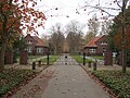
Ehrenfriedhof 53.5456 ° N , 8.1027 ° O
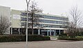
Jade University 53.5483 ° N , 8.0877 ° O

IGS Friedensstraße 53.5345 ° N , 8.0928 ° O
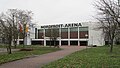
Nordfrost Arena 53.5346 ° N , 8,095 ° O

Jade Stadium 53.5366 ° N , 8.0958 ° O

Nautimo (pool) 53.5359 ° N , 8.0982 ° O

Käthe-Kollwitz-school 53.5351 ° N , 8.1093 ° O

Rosarium 53.542 ° N , 8.1073 ° O


Web links
- District portrait "Rüstringer Stadtpark" ( Memento from September 2, 2013 in the Internet Archive )
Individual evidence
- ^ City of Wilhelmshaven: District Rüstringer Stadtpark. December 31, 2007, accessed November 25, 2018 .
- ^ City of Wilhelmshaven: District Rüstringer Park history. December 31, 2007, accessed November 25, 2018 .
Aldenburg | Altengroden | Bant | Ebkeriege | Fedderwarden | Fedderwardergroden | Heppens | Heppenser Groden | Kingdom of Heaven / Coldewei | Inner Harbor | Downtown | JadeWeserPort | Langewerth | Maadebogen | New end | Neuengroden | Rustersiel | Rustersieler Groden | Rüstringer City Park | Schaar | Sengwarden | Siebethsburg | Voslapp | Voslapper Groden