
Neuengroden
|
Neuengroden
City of Wilhelmshaven
Coordinates: 53 ° 33 ′ 0 ″ N , 8 ° 6 ′ 39 ″ E
|
|
|---|---|
| Height : | 2 m |
| Area : | 2.11 km² |
| Residents : | 3908 (December 31, 2017) |
| Population density : | 1,856 inhabitants / km² |
| Postal code : | 26386 |
| Area code : | 04421 |
 Location of Neuengroden in Wilhelmshaven
|
|

Neuengroden is a district in the northeast of Wilhelmshaven in Lower Saxony. Neighboring districts are Altengroden in the northwest (west of Lönsweg), Rüstersiel in the northeast, Rüstringer Stadtpark in the west (border Lönsweg, Neuengrodener Weg and Friedensstrasse) and Heppens in the south (southeast of Friedensstrasse). In the east, from Friesendamm, the industrially used area of the Heppenser Groden connects with the oil port and parts of the base of the German Navy and the Rustersieler Groden .
history
Neuengroden's prehistory is closely linked to the history of dyke construction. Because it was only through the construction of the Neuengroden dike in 1520 that the land on which Neuengroden lies today could be won. Freiligrathstraße, which runs through the whole of Neuengroden, runs roughly in the direction of the former dike. A provisional settlement was built west of Freiligrathstrasse at the beginning of World War II. It has been fundamentally modernized over the past few years. To the east of Freiligrathstrasse, mainly terraced and single-family houses were built. Allotment garden associations contribute to the green image of Neuengroden.
Infrastructure
The townscape is characterized by terraced and single-family houses as well as numerous allotment gardens . On the former site of the former Frisia sports club on Triftweg, the Erich-Kästner-Ring development area is being built with 31 new residential buildings.
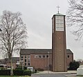
In Neuengroden there is the former Catholic branch church St. Michael , which belongs to the municipality of St. Willehad, but which was profaned in 2013 and has since been used by the Maltese relief service . The larger Protestant congregation with the St. Thomas Church is located in the center of the district. Both parishes have a kindergarten. The Neuengroden primary school, which was built in 1900, was closed at the beginning of the 2009/2010 school year. The cemetery in Friedensstrasse is also part of Neuengroden.
At 5.7%, the unemployment rate is below the Wilhelmshaven average of 9.3% (as of December 15, 2010).
To the west of Neuengroden lies the Rüstringen city park with a pond where you can go pedal boating in summer, the "Bootshaus" restaurant and the cemetery of honor . To the east of Neuengroden is the Wilhelmshaven oil port and parts of the naval arsenal .
Residents
development
Since 2000 the population of Neuengroden has decreased. On December 31, 2017, the district still had 3,908 inhabitants.
Share of foreigners and migrants
In 2007, 1.7% of the Neuengrodener were of foreign descent whereas in 2017 it was 4.4%. The Wilhelmshaven average is 9.6%. The proportion of migrants is 15.4% with an urban average of 21.8%.
colonization
Neuengroden has an area of 210.6 hectares. The population density is 18.8 inhabitants per hectare. The district is therefore as populated as the districts of Schaar and Voslapp (as of 2007).
Age
The average age of the residents of Neuengroden is 49.7 years. This means that the district has the third highest average age of all Wilhelmshaven districts after Siebethsburg and Neuende . 30.1% of the Neuengrodener are 65 years and older and only 11.4% are minors. This means that the district has a value 5 percentage points higher than the urban average - however, due to several old people's and care facilities
marital status
Due to the above-average proportion of senior citizens, Neuengroden, together with the city center, also has the second-highest proportion of widowed people. 9.5% of residents were widows or widowers on December 31, 2017. However, the majority of residents are married or have a partner (44.8%).
Movement of residents
In 2017, 83 deaths almost tripled the 19 births. The locations of several old people's and nursing homes are noticeable here. Half of the deaths relate to 4 facilities alone. In terms of spatial population movements, Neuengroden was able to gain 528 residents in 2017. Although the external migrations beyond the city limits led to migration losses, a clearly positive balance was achieved for inner-city removals. The balance for the district as a whole: +67 inhabitants.
Business
On Freiligrathstraße there is a Lidl supermarket, a Jet petrol station and a shoemaker at the level of Neuengrodener Weg . Several nurseries and flower shops have settled in Neuengroden.
history
The district is built on the land that was gained in 1520 by diking with the construction of the Neuengroden dike . Until the unification of Rüstringen and Wilhelmshaven (1939) Neuengroden belonged to Rüstringen. In 1939 a settlement was built here, which was later modernized.
Worth seeing
- Baptismal window of St. Thomas Church and the "Thomas figure" by the Polish artist Sled'z, as well as the pipe organ by Alfred Führer
- Former Catholic Church of St. Michael (built in 1954)
- Former elementary school Neuengroden (built in 1900)
- Old chapel and new mourning hall in the Friedenstrasse cemetery
Nearby:
Views

Cemetery, old chapel

Cemetery, information pavilion
Thomas Church


Individual evidence
- ^ City of Wilhelmshaven: Neuengroden district. December 31, 2007, accessed November 25, 2018 .
- ↑ Sta (d) tistik-Report 2-2011 (PDF, 8 MB)
- ^ City of Wilhelmshaven: Neuengroden district 2017. December 31, 2017, accessed on November 25, 2018 .
- ^ City of Wilhelmshaven: Neuengroden district 2007. December 31, 2007, accessed on November 25, 2018 .
- ^ City of Wilhelmshaven: Neuengroden district. December 31, 2017, accessed November 25, 2018 .
- ^ City of Wilhelmshaven: Neuengroden district. December 31, 2017, accessed November 25, 2018 .
- ^ City of Wilhelmshaven: Neighborhood Neuengroden Wilhelmshaven. December 31, 2017, accessed November 25, 2018 .
Web links
Aldenburg | Altengroden | Bant | Ebkeriege | Fedderwarden | Fedderwardergroden | Heppens | Heppenser Groden | Kingdom of Heaven / Coldewei | Inner Harbor | Downtown | JadeWeserPort | Langewerth | Maadebogen | New end | Neuengroden | Rustersiel | Rustersieler Groden | Rüstringer City Park | Schaar | Sengwarden | Siebethsburg | Voslapp | Voslapper Groden