Maadebogen
|
Maadebogen
City of Wilhelmshaven
Coordinates: 53 ° 33 ′ 0 ″ N , 8 ° 4 ′ 40 ″ E
|
|
|---|---|
| Residents : | 1583 (2017) |
| Postal code : | 26389 |
| Area code : | 04421 |
|
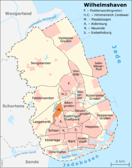
Location of Maadebogen in the city of Wilhelmshaven
|
|
Maadebogen is a district of the independent city Wilhelmshaven in Lower Saxony .
location
The district is bordered in the northeast by Ostfriesenstrasse, in the east by Kurt-Schumacher-Strasse, in the south by Fort Schaar and in the west by the Maade . It is close to the Rüstringen city park , the Jade University and the Reinhard Nieter hospital with the local health center.
history
The development of the district took place in three development sections. The first development plan area No. 92C Maadebogen-Süd with around 100 plots for detached single-family houses was developed and developed from December 1981. The purchase price of the land was fully developed 70 DM / m². The second development plan area No. 92D Maadebogen-Nord was developed from 1984/1985. It offered space for around 130 building plots. The price per square meter was now 72 DM / m². The development of the third development plan area No. 92E Maadebogen-Mitte was delayed due to disputes with the nature conservation authorities, although planning had started together with the second section. The reason for the construction phase was still waters , former bomb craters , in which biotopes had developed through special plants and animals. It was not until 1990 that almost 150 building plots could be made available in this section. In addition, space was created in this section for the central supply facilities.
The streets in the Maadebogen were named after famous explorers and inventors .
Origin of name
The Maadebogen district is named after the Maade river, whose name is derived from the Frisian word "mada" for meadow, swampy, boggy soil and which makes its characteristic curve in this section of the river.
Infrastructure
The road system in the Maadebogen consists of a ring road ( Columbus ring and Magellan road ) in the south and a loop in the road connected to Ostfriesenstrasse and Kurt-Schumacher-Strasse (Sven-Hedin-Strasse) in the north. Both streets are connected by Beringallee . In addition, additional car-free residential paths connect the properties with one another.
The bus line 3 of the Stadtwerke-Verkehrsgesellschaft Wilhelmshaven Jade-Viertel - Güterstrasse - Maadebogen - Reinhard-Nieter-Krankenhaus / Jadehochschule connects the district to the local public transport .
At the confluence of Sven-Hedin-Strasse and Kurt-Schumacher-Strasse there is a small supply center that provides all the shopping opportunities for daily needs.
The eastern bank of the Maade was designed as a public green area and has a path for pedestrians and cyclists.
In the north of the district, high-voltage lines run across the site between Maade and the residential area.
Residents
In 2017 the district had 1583 inhabitants, compared to 2045 inhabitants in 2000.
Share of foreigners and migrants
Just 1.5% of the inhabitants of the Maadebogen are foreigners, the Wilhelmshaven average is 9.6%. The proportion of migrants is 13.8%, compared to an urban average of 21.8%.
colonization
With its 92.7 hectares, the Maadebogen is the third smallest district after Neuende and Siebethsburg. Mathematically, 17.3 inhabitants live here per hectare. This means that the Maadebogen has a higher population density than the neighboring district of Altengroden, which has significantly more residents.
Web links
- District portrait "Maadebogen" on Wilhelmshaven.de ( page no longer available )
- Maadebogen Citizens' Association
Individual evidence
- ↑ Maadebogen Citizens' Association - History , accessed on February 26, 2014
- ↑ a b c City of Wilhelmshaven: Small-scale population statistics 2018. December 31, 2017, accessed on December 7, 2018 .

