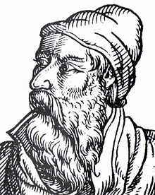
Job Magdeburg
Job Magdeburg (also Jobus and Magdeburger ; * 1518 in Annaberg ; † February 20, 1595 in Freiberg ) was a German theologian, educator, cartographer and humanist of the Reformation period .
Life
Job Magdeburg is the son of the Saxon mint master and die cutter Hieronymus Magdeburg , his grandfather Paul Magdeburg was the mayor of Freiberg. After attending school in his hometown, Magdeburg is attested as a teacher in Annaberg as early as 1537. In 1540 he was enrolled in the philosophy faculty in Wittenberg , and from 1541 he was a teacher at the Princely School of St. Afra in Meißen . Since 1543 Tertius ( sub-rector ) at St. Afra, he was dismissed in 1569 because of his partisanship for Matthias Flacius as a Gnesiolutheran .
In 1570 he became rector of the Katharineum in Lübeck , where he only stayed until 1574. Here, too, he was involved in theological disputes and was accused of Manichaeism . He went to the princely Latin school (today: Fridericianum Schwerin ) as rector in Schwerin and in 1576 became educator of the Mecklenburg princes.
In 1592 he is attested again in Saxony, namely as a private teacher in Annaberg and Freiberg.
cards

The oldest map of the margraviate of Meissen , a woodcut 134 millimeters wide and 122 millimeters high, was created by Job Magdeburg. He monogrammed and dated his work in the upper right corner. He labeled it in Latin and called it Misnia charta . The map was created in 1560. The only copy was found by chance in 1913 in the Zwickau council school library .
Magdeburg's most important legacy is not of a theological or educational nature, but a cartographic work . In 1566, during his time at St. Afra in Meißen, he made the Duringische and Meisnische Landtaffel , a map painting with a scale of approx. 1: 215,000, on behalf of Elector August von Sachsen . The map shows the Wettin lands and was unique and served exclusively for internal princely purposes. It is already documented in the oldest Kunstkammer inventory from 1587. The actual map image is framed by a 10 cm wide frieze with 46 portraits of princes. The geographical area shown extends in the north to Magdeburg , Zossen and Teupitz , in the east to Sommerfeld ( Lubsko ) and Zittau , in the south to Eger and in the west to Salzungen and Goslar . Over 500 settlements can be found on the map. They were entered on the map with different sized vignettes according to their administrative importance and taking into account the number of residents . Today the card is on display in the SLUB Dresden Book Museum and can also be accessed online as a digital copy. Job Magdeburg, in the opinion of Axelle Chassagnette with its maps of 1560 and 1566 the first important contact [made], produce reliable maps of the country .
literature
- Michael Wetzel: Job Magdeburg . In: Institute for Saxon History and Folklore (Ed.): Saxon Biography .
- Johann August Müller: attempt of a complete history of the Chursächsische Fürsten- und Landschule zu Meissen from documents and credible news , second volume, bey Siegfried Lebrecht Crusius, Leipzig 1789, p. 205ff. Digitized
- Friedrich August Eckstein : Nomenclator philologorum. Teubner, Leipzig 1871; Reprint Olms, Hildesheim 1966 ( digitized; PDF 2.8 MB ).
- Jakob Franck : Magdeburg, Job . In: Allgemeine Deutsche Biographie (ADB). Volume 20, Duncker & Humblot, Leipzig 1884, pp. 51-53.
- Rainer Gebhardt (Ed.): Job Magdeburg and the beginnings of cartography in Saxony. Annaberg-Buchholz: Adam-Ries-Bund 1995 ISBN 3-930430-03-7
- Karl Olzscha: Job Magdeburg (1518–1595). Life picture of an Annaberg In: Messages of the Association for History of Annaberg and Surrounding Area 6 (1898), pp. 45–60
- Woldemar Lippert : The "Sächsische Stammbuch", a collection of Saxon prince portraits, in: NASG 12, 1891, pp. 64–85
Web links
- Map of the Margraviate of Meissen from 1560 in the German digital library
- Duringische and Meisnische Landtaffel from 1566 digital in the map forum of the SLUB Dresden
Individual evidence
- ↑ Jakob Franck: Magdeburg, Job . In: Allgemeine Deutsche Biographie (ADB). Volume 20, Duncker & Humblot, Leipzig 1884, pp. 51-53.
- ↑ Johann August Müller: Attempt of a more complete history of the Chursächsische Fürsten- und Landschule zu Meissen from documents and credible news , second volume, bey Siegfried Lebrecht Crusius, Leipzig 1789, p. 205 digitized
- ↑ Johann August Müller: Attempt of a more complete history of the Chursächsische Fürsten- und Landschule zu Meissen from documents and credible news , second volume, bey Siegfried Lebrecht Crusius, Leipzig 1789, p. 206 digitized
- ↑ a b Axelle Chassagnette: Printed maps of Saxony in the second half of the 16th century: the representation of history and territory in the mirror of learned cartography , in: Johannes Helmrath, Albert Schirrmeister, Stefan Schlelein (ed.): Historiographie des Humanismus - Literary procedures, social practice, historical spaces , Verlag de Gruyter, Berlin 2013, p. 260 digitized
- ↑ Sächsische Heimat, communications from the federal state team of Saxony, Stuttgart, issue June / 1978, p. 185
- ^ Map in the German Digital Library
- ↑ Sächsische Heimat, communications from the federal state team of Saxony, Stuttgart, June / 1978 issue, p. 186
- ↑ Description of the card in the Dresden Book Museum (PDF; 61 kB)
- ↑ Link to the map from 1566 in the Dresden State and University Library
| predecessor | Office | successor |
|---|---|---|
| Jacob Hesse |
Rector of the Katharineum in Lübeck 1570–1574 |
Joachim Hemp |
| personal data | |
|---|---|
| SURNAME | Magdeburg, Job |
| ALTERNATIVE NAMES | Magdeburg, Jobus; Magdeburg, Job |
| BRIEF DESCRIPTION | German theologian, pedagogue, cartographer and humanist of the Reformation period |
| DATE OF BIRTH | 1518 |
| PLACE OF BIRTH | Annaberg |
| DATE OF DEATH | February 20, 1595 |
| Place of death | Freiberg |

