
Hochplatte (Ammergau Alps)
| High plate | ||
|---|---|---|
 East view of the Ammergau plateau |
||
| height | 2082 m above sea level NN | |
| location | Bavaria , Germany | |
| Mountains | Ammergau Alps | |
| Dominance | 4.3 km → Vulture heads | |
| Notch height | 964 m ↓ Ammersattel | |
| Coordinates | 47 ° 33 '11 " N , 10 ° 50' 36" E | |
|
||
| rock | Wetterstein lime | |
| Age of the rock | Triad | |
| Normal way | Kenzenhütte - Scheinbergalpe - east side - Hochplatte (east rise) | |

.JPG)
The high plateau is a 2082 m above sea level. NHN high mountain in the Ammergau Alps and the highest point in the Ostallgäu district . To better distinguish it from other mountains with this name in the Northern Limestone Alps , it is also referred to as the Ammergauer Hochplatte . It is a striking rock slab made of Wetterstein limestone, clearly towering over the area, with an east and the main summit. Due to its exposed location as a panoramic mountain , the Hochplatte is a popular destination for hikes and ski tours .
location
The summit is about seven kilometers east of Füssen in the German state of Bavaria . Neighboring mountains are in the west (towards Füssen) and northwest Krähe , Gabelschrofen , Gumpenkarspitze and Geiselstein 1884 m above sea level. NHN and north of the Firstberg 1783 m above sea level. NHN . To the east, the Scheinbergspitze is 1929 m above sea level. NHN . To the south, the karst terrain slopes down to the Ammersattel . The high plateau is located in the Ammergebirge nature reserve (NSG-00274.01).
Base and tours
- The easiest way to the high plateau leads from the Kenzenhütte 1294 m above sea level. NHN over the Scheinbergalpe and then through karst terrain over the east side to the summit. According to literature, the ascent takes about two and a half hours. In fact, at least 3 hours should be expected.
- A more demanding tour (according to the literature, UIAA I level of difficulty ) leads from the Kenzenhütte in a good three hours over the Gumpenkar from the west to the summit. Wire rope insurances are available in difficult places.
gallery
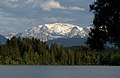
Schmutterweiher with high platform

Hochplatte in the sunset

Plateau from the northwest

Summit cross


,_Gipfelkreuz.jpg)
Literature and map
- Dieter Seibert: Alpine Club Guide Allgäu and Ammergau Alps . Bergverlag Rother , Munich 2004, ISBN 3-7633-1126-2
- Freytag & Berndt , hiking map 1: 50,000, sheet WK 352
Web links
- Route description in the hiking guide, view in Google Books
- Ammergauer Hochplatte ski tour - route description
Individual evidence
- ↑ Geological map of Bavaria with explanations (1: 500,000). Bavarian Geological State Office, 1998.
- ↑ Federal Agency for Cartography and Geodesy , State Office for Surveying and Geoinformation Bavaria : Digital Topographic Map 1:25 000, BayernAtlas , accessed on January 9, 2016
- ↑ protectedplanet.net