High Mandling
| High Mandling | ||
|---|---|---|
|
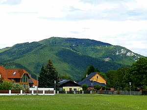
Hohe Mandling (967 m) with the upper part of the sweet walls, taken in the Raimundviertel in Pernitz |
||
| height | 967 m above sea level A. | |
| location | Lower Austria | |
| Mountains | Gutenstein Alps | |
| Dominance | 5.8 km → Hohe Wand | |
| Notch height | 337 m ↓ Geyersattel | |
| Coordinates | 47 ° 53 '42 " N , 16 ° 0' 32" E | |
|
|
||
| Normal way | Hike | |
The Hohe Mandling (sometimes: the Hohe Mandling ) is 967 m above sea level. A. high mountain in the Gutenstein Alps in southern Lower Austria .
Location and surroundings
The Hohe Mandling rises two kilometers north of the Piestingtal with quite steep flanks . The entire western part of the Bergstock and its highest point belong to the area of the market town of Pernitz in the Wiener Neustadt-Land district . The southeast flank is in the area of the market town of Waldegg , while the northeastern foothills belong to the municipality of Hernstein and thus already belong to the Baden district .
The Feichtenbach rises north of the Bergstock and flows into the Piesting in the Ortmann district of Pernitz . The Geyersattel forms the northern border to the neighboring mountain Waxeneck . The Veitsauer Bach rises here and flows northeast through Grillenberg into the Triesting . The mountain is separated from the slightly lower Vorderen Mandling to the east by the Stampftal valley.
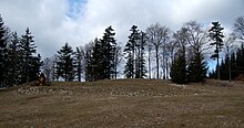
The Hohe Mandling is a popular destination for hikers. On the summit of the mountain, on the so-called Knödelwiese, stood the Berndorfer Hut , which burned down in 2007 and the remaining foundation walls were subsequently also removed.
Origin of the name
The Hohe Mandling was first mentioned in 1369 as Mandlich . According to Heinz Pohl , the name is of Slavic origin and is derived from Slavic * monьnika , from * monĭ- / * moń- (= "neck", "saddle"). This stem developed the same meaning as the Latin collum (= "neck" to "saddle", "pass").
There is disagreement about whether Mandling is male or female. Both the term “Hohe Mandling” and “Hoher Mandling” can be found on maps. The BEV cards use the feminine form.
history
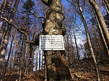
On November 20, 1866, the last wolf in Lower Austria between Fotzeben and the Hohen Mandling was shot by the archducal Forstadjunkten Michael Wagner from the Berndorf district of Steinhof. Not only a memorial plaque that was hung up at that point reminds of this, but also the legends widespread in the area about a ghost wolf who is said to haunt the wolf beech tree and the wolf ghost ( location ) north of Pottenstein .
On August 1st, 1920, the "Berndorf and Surroundings" local group opened the Berndorfer Hütte as a provisional facility in a purpose-built hunting lodge belonging to the Herrstein Forest and Domain Directorate to make the Mandling area easier for tourists. The already planned refuge, for the realization of which the funds had not yet been sufficient , could be viewed as a 1:25 scale model next to the temporary building (which could accommodate 20 people overnight on bunk beds with hay ).
At the instigation of the Berndorfer Turnverein Jahn , the first mountain gymnastics festival took place on September 8, 1923 on the appropriately prepared mountain meadow . This event based on the folkish idea (from 1925: Gau-Bergturnfest ) took place annually, with the exception of 1934, until 1943 (the 19th time). Sometimes 400 people took part in the athletic competitions; for some of the up to 2000 visitors (in addition to the limited number of accommodations in the refuge and a nearby hunting lodge) tents were set up; Those who couldn't find accommodation near the summit chose the morning ascent preferably from the head of the Grillenberg valley belonging to Hernstein , the Schwaig , where a bicycle parking lot was set up in some years.
After two years of construction, the original building project was successfully completed on July 27, 1924 with an opening ceremony. The Berndorfer Hütte was used by partisans and deserters as a center of armed resistance against National Socialism during the Second World War because of its inaccessible location .
When the Berndorfer Group was not re-established after the Second World War, the Austrian Mountain Association took over the Berndorfer Hütte, which (after some administrative problems during the 1980s) came to the Baden Group, which was founded as an association in 1979 . Newly signed tenants renovated the refuge in 1980 and in this way kept it as a place to stay and eat for visitors to the mountain. From November 9th to 10th, 2007, the hut burned down to the ground for an unexplained cause , a fire -fighting action involving 27 emergency vehicles remained unsuccessful due to the one -shift location.
ways
The Hohe Mandling can be reached in the following ways:
- From Grillenberg, Hernstein municipality, the Hohe Mandling opens up via a forest path through the Fotzeben .
- From Neusiedl, Hernstein municipality, a forest path goes over the small and large Rosenkogel to the Hohe Mandling.
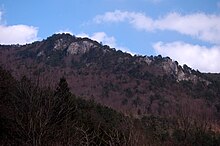
- From Reichental, municipality of Waldegg, the Quarb can either be reached from the valley narrowing along the sweet walls or over the Mozart rock to the summit.
- Hiking route 231 up to the peak over the Kleine Rosenkogel ( 730 m ) begins in Waldegg, but can also be reached from Oed (also Waldegg) via the Stampftal and from Alkersdorf via hiking trail 201A.
- From the Ortmann district in Pernitz , the summit can be reached via the steep hiking trail 36.
- From Feichtenbach , also a municipality in Pernitz, a steep hiking trail leads over the Geyersattel to the summit of the Hohen Mandling.
The next option for food and accommodation is the Waxeneckhaus at 785 meters above sea level, which is located near the Geyersattel on the Waxeneck.
literature
- Csaba Szépfalusi: Wandererlebnis Wienerwald and Gutenstein Alps , Kral-Verlag, Berndorf 2011. ISBN 978-3-99024-023-6
Web links
Individual evidence
- ↑ Kurt Kettner (inter alia): Eastern Alps. Refuge huts in Germany, Austria and South Tyrol. 1074 shelters and bivouac boxes of the DAV, OeAV, AVS and CAI as well as numerous other alpine associations and private managers . 9th edition. The Alpine Club huts. Volume 1. Bergverlag Rother , Munich 2005, ISBN 3-7633-8073-6 , p. 228, online , accessed on October 5, 2010.
- ↑ Mountain names after Heinz Pohl
- ^ ÖK 50 in the Geoland database
- ^ Pa .: Opening of the Berndorfer Hütte on the Hohen Mandling. In: Der Gebirgsfreund. Journal of the Oesterreichischen Gebirgsverein , year 1920, no. 9-10 / 1920, September 15, 1920 (XXXI. Year), p. 135. (Online at ANNO ). .
- ^ Triestingtaler Nachrichten. Mountain gymnastics festival on the Hohe Mandling. In: Badener Zeitung , No. 70/1943 (LXIV. Volume), September 4, 1943, p. 5, center right. (Online at ANNO ). .
- ^ Triestingtaler Nachrichten. To the mountain gymnastics festival on the Hohe Mandling. Sunday, September 5, 1943. In: Badener Zeitung , No. 69/1943 (LXIV. Volume), September 1, 1943, p. 3, center right. (Online at ANNO ). .
- ^ Triestingtaler Nachrichten. Mountain gymnastics festival on the Hohe Mandling. In: Badener Zeitung , No. 72/1943 (LXIV. Volume), September 11, 1943, p. 5, bottom left. (Online at ANNO ). .
- ^ R. Lauer: The opening of the Berndorfer hut. In: Der Gebirgsfreund. Journal of the Austrian Mountain Association , year 1924, No. 10/1924, October 1, 1924 (XXXV. Year), p. 124 f. (Online at ANNO ). .
- ^ Julius Böheimer: Associations of Baden near Vienna . Baden Press Club , Baden 2001, p. 129 f.
- ↑ Feichtenbach . In: Peter Aichinger-Rosenberger (among others): Lower Austria south of the Danube. Band 1: A to L . Dehio-Handbuch , Die Kunstdenkmäler Österreichs, topographic monuments inventory. Berger, Horn / Wien 2003, ISBN 3-85028-364-X , p. 424.
- ↑ The shelter burned down to the ground . In: oesterreich.orf.at , November 10, 2007, accessed on October 25, 2013.
- ↑ Mission report of the district fire brigade command Wiener Neustadt
- ^ A b Franz and Rudolf Hauleitner: Wiener Hausberge. Hohe Wand, Schneeberg, Raxalpe, Semmering. 52 selected hikes . 6th edition. Rother-Wanderführer, Munich 2009, ISBN 978-3-7633-4216-7 , pp. 40 f., Online , accessed on October 5, 2010.
Remarks
- ↑ In 1919 it was possible to acquire shares in favor of the establishment of the Mandlingschutzhaus . - See: Share certificate for the Mandlingschutzhaus. In: Badener Zeitung , October 29, 1919, p. 3 middle. (Online at ANNO ).
- ↑ When the Scheimhütte burned down on the Hohe Wand in the night of September 1st to 2nd, 2013 for no apparent reason, the Lower Austria Regional Criminal Police Office took this as an opportunity to re-examine the destruction of the Berndorfer Hütte with regard to arson. - See: Kripo investigates arson. In this context, a major fire from 2007 is being re-examined . In: kurier.at , September 4, 2013, accessed on December 28, 2013.


