Grillenberg (Hernstein municipality)
|
Grillenberg ( village ) locality cadastral community Grillenberg |
||
|---|---|---|
|
|
||
| Basic data | ||
| Pole. District , state | Baden (BN), Lower Austria | |
| Judicial district | to bathe | |
| Pole. local community | Hernstein | |
| Coordinates | 47 ° 55 '35 " N , 16 ° 5' 10" E | |
| height | 356 m above sea level A. | |
| Residents of the village | 371 (January 1, 2020) | |
| Area d. KG | 7.16 km² | |
| Post Code | 2560 | |
| prefix | + 43/02672 | |
| Statistical identification | ||
| Locality code | 03388 | |
| Cadastral parish number | 04311 | |
| Counting district / district | 002 (30614) | |
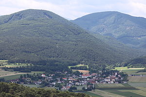
 Grillenberg vom Guglzipf |
||
| Source: STAT : index of places ; BEV : GEONAM ; NÖGIS | ||
Grillenberg is a village and a cadastral municipality in the market town of Hernstein in Lower Austria with 371 inhabitants (as of January 1, 2020).
location
Grillenberg is located south of Berndorf in the Grillenberg Basin , a fertile plain that is damp and swampy in places and through which the Veitsauer Bach flows. The Veitsauer Bach rises northeast of the Hohe Mandling , flows through the Grillenberger Tal, through Grillenberg to Veitsau and flows into the Triesting in Berndorf .
history
Grillenberg was first mentioned in a document in 1265. In 1590 the place then comprised 14 houses, 9 of which belonged to Melk Abbey . On March 4, 1849, the mill owner Werner Singer was elected first mayor. On January 1, 1971, the previously independent municipalities of Hernstein, Grillenberg and Kleinfeld joined together voluntarily to form the municipality of Hernstein.
Culture and sights
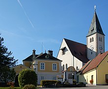
- Catholic parish church Grillenberg hl. Margareta
- Parsonage Grillenberg
economy
Grillenberg was known for the pitching in the forests all around and the resins, pitch and turpentine oils obtained from them, which were also sold abroad.
The lignite depots , which stretched north from Grillenberg and Neusiedl near Grillenberg to Veitsau , were first opened up in 1842 by Alois Miesbach , but with little success due to the large amount of water. In 1861 Heinrich Ritter von Drasche had three shafts sunk, the Louisenschacht near Grillenberg, the Richardschacht near Neusiedl and the Leopoldschacht on Hernsteiner Straße. In the approximately 26.5 m deep Leopold Shaft, the coal was found 1.6 to 1.9 m thick. Because of the large amount of water, two steam engines (with 4 and 6 HP) were set up, which served as pumps and at the same time for conveyance. A large part of the coal went to Wienerberger Ziegelwerke , but the company ran into economic difficulties from 1877 and was shut down around 1880.
From 1896 the Berndorfer Metallwarenfabrik received the mining rights from Arthur Krupp and built the reel shaft with a depth of 10 meters between Veitsau and Grillenberg. Mining began in 1901 and during the First World War the coal was transported directly to the metal goods factory by cable car over the Guglzipf . Furthermore, an opencast mine was set up between Veitsau and Grillenberg and in 1916 work began on the Barbarastollen near Neusiedl , which went into operation in 1918. The deposits continued to be exploited until they were exhausted and operations were closed in 1959.
literature
- The art monuments of Austria. Dehio Lower Austria south of the Danube 2003 . Grillenberg, Hernstein parish, parish church St. Margareta, rectory. Pp. 602-603.
- Helene Schießl, Walter Hejduk: Mining in the Grillenberger basin and the colony . KRAL-Verlag, Berndorf 2009, ISBN 978-3-902447-71-5 .
Web links
Individual evidence
- ↑ Statistics Austria: Population on January 1st, 2020 by locality (area status on January 1st, 2020) , ( CSV )
- ↑ Grillenberg. Market town of Hernstein, accessed on August 17, 2018 .
- ↑ Hernstein since 1945. Market town of Hernstein, accessed on August 17, 2018 .
- ^ Wenzel Carl Wolfgang Blumenbach : Latest regional studies of Austria under the Ens . tape 2 . Carl Reichard, Güns 1835, p. 275 ( digitized in Google Book Search [accessed on August 17, 2018]).
- ↑ Leopold Weber, Alfred Weiß: Mining history and geology of the Austrian lignite deposits , Federal Geological Institute, Vienna 1983 PDF p. 251ff


