
High cutting edge
Monte Cristallo high edge |
||
|---|---|---|
 High cutting edge seen from Monte Scorluzzo , to the left the Great Naglerspitze |
||
| height | 3434 m slm | |
| location | south of the Stilfser Joch , Province of Sondrio , Italy | |
| Mountains | Ortler Alps | |
| Coordinates | 46 ° 29 '44 " N , 10 ° 27' 25" E | |
|
||
| rock | Main dolomite | |
| First ascent | 1872 | |
 Map of the area |
||
 Approximate course of the attack tunnel in the First World War |
||

The Hohe Schneide or Hohe Schneid , Italian Monte Cristallo , is a 3434 m slm high mountain in the Ortler Alps , which was mainly known for its importance in the mountain war of 1915-1918 (see section history ).
Location and surroundings
The Hohe Schneide is located in the Italian province of Sondrio about 3.5 kilometers south of the Stilfser Joch in the crystal ridge . This mountain ridge, which runs in a west-east direction, forms the border between the municipalities of Bormio in the north and Valfurva in the south. The 250 meter high glaciated north side of the mountain lies above the glacier basins of the Vedretta del Cristallo and Vedretta dei Vitelli, some of which are developed as a summer ski area . The south side drops down as a steep rock face into the Valle di Zebrù . In the west is the Passo di Ables ( 3012 m ), to the east the ridge continues to the Passo di Sasso Rotondo ( 3335 m ) and the crystal peaks ( Cime di Campo , 3480 m ), to the northwest is the Geisterspitze ( Punta degli Spiriti , 3467 m ). The mountain is part of the Stilfserjoch National Park .
Bases and paths
The most important base when climbing the Hohe Schneide is the Livriohütte ( Rifugio Monte Livrio , 3174 m ) north of the mountain. From here the summit can be reached in around two hours via the east ridge, which is classified as a technically easy high-altitude tour . The route through the south face from the Zebrù Valley is more difficult with difficulty level II (UIAA) . The southwest ridge has difficulty I. It can be reached both from the Livriohütte and from the south via the Passo di Ables, where the Bivacco Provolino bivouac box is available as a base . The north face is a firn and ice tour with a steepness of about 55 °: Further climbs from the north are the equally difficult diagonal path in its eastern part, the direct north face and the north-west face .
history
The Hohe Schneide was founded on August 26, 1872 by Dr. Oster and his guide J. Mazagg first climbed the east ridge . Occasionally mentioned earlier ascents, such as by Francis Fox Tuckett and companions on August 1, 1864 or Julius Payer and Johann Pinggera on September 28, 1866 actually refer to the nearby crystal peaks, which at that time were also sometimes called "Monte Cristallo" or "Cristallo peaks". were designated.
Apart from the development of the southwest ridge (in 1872 in two variants by P. Pogliaghi and Ludwig Purtscheller ), the mountain was otherwise of little importance for a long time.
During the First World War , the Ortler Alps became a frontline area. The Austro-Hungarian army had occupied most of the Kristallkamm, Monte Scorluzzo , the Geisterspitze and the Große Naglerspitze . In contrast to strategically more important peaks such as the Ortler , the Hohe Schneide remained vacant for a long time due to a lack of staff and was at most visited by patrols from time to time. In October 1916 the Italians occupied the Hohe Schneide and from here they took the Austrian positions under fire with machine guns. Since storming the summit over the icy north face seemed hopeless, the Austrian army decided to attack the Hohe Schneide through an approximately two kilometer long tunnel in the glacier ice. For five months, with the help of a pick, drill bit and shovel, but for reasons of secrecy but without the use of explosives, a steep tunnel was driven steeply up through the ice in serpentines and bends, which also contained wooden barracks. On March 17, 1917, Italian mountaineers, the Alpini , who for their part built their own tunnel on the summit, encountered the Austrian tunnel. A fight ensued from which the Austrians emerged victorious. As a result, the summit of the Hohe Schneide was equipped with positions, ammunition stores and barracks. A new, flatter ice tunnel was built through the east ridge to the summit, and a cable car from the Großer Naglerspitze to the Hohe Schneide was also built. The southwest ridge remained in the hands of Italy. In 1918 there was an attack on this position from the summit, again with the help of an ice tunnel, but this was unsuccessful. Until the end of the war, the positions of the warring factions remained only about ten meters apart. The entire system of ice tunnels and crevasses in the area of the Hohe Schneide and the adjacent glaciers has been expanded to up to ten kilometers over the course of time.
During the war, several new routes to the summit were also developed. A few more climbs, particularly through the north face, were first climbed during the 1920s and 1930s. In addition, Heini Holzer's first ski ascent of the direct north face of the Hohe Schneide in 1970 is of alpine importance.
photos

Construction of the ice tunnel
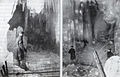
Field guard in an ice cave ("miracle grotto") in the tunnel

Entrance to the later ice tunnel built in 1917

The barracks built into the ice below the summit

Gravestone of a soldier who died on the Hohe Schneide in the Spondinig war cemetery


literature
- Peter Holl: Alpine Club Guide Ortleralpen . Ed .: German Alpine Association , Austrian Alpine Association , Alpine Association South Tyrol . 9th edition. 2003, ISBN 3-7633-1313-3 , pp. 158-160 ( Google Books [accessed March 13, 2010]).
- Professor Dr. Easter: the journal of the German and Austrian Alpine Association Volume V . Ed .: German and Austrian Alpine Club . 1874, p. 153–161 ( The Hohe Schneide. First ascent. [Accessed on April 15, 2017]).
Web links
Individual evidence
- ^ Peter Holl: Alpine Club Guide Ortleralpen . Ed .: German Alpine Association , Austrian Alpine Association , Alpine Association South Tyrol . 9th edition. 2003, ISBN 3-7633-1313-3 , pp. 28 ( Google Books [accessed March 13, 2010]).
- ↑ According to Italian surveying, according to Austrian surveying 3431 m slm , cf. Peter Holl: Alpine Club Guide Ortleralpen . Ed .: German Alpine Association , Austrian Alpine Association , Alpine Association South Tyrol . 9th edition. 2003, ISBN 3-7633-1313-3 , pp. 158 ( Google Books [accessed March 13, 2010]).
- ↑ a b c d Peter Holl: Alpine Club Guide Ortleralpen . Ed .: German Alpine Association , Austrian Alpine Association , Alpine Association South Tyrol . 9th edition. 2003, ISBN 3-7633-1313-3 , pp. 158-160 ( Google Books [accessed March 13, 2010]).
- ↑ a b F.F. Tuckett: Contributions to the Topography of the Orteler and Lombard Alps . Alpine Journal, Vol. I. No. 8, German in: Jahrbuch des OeAV, Volume 1, 1865, p. 241
- ^ R. Hösch: Pinggera, Johann. In: Austrian Biographical Lexicon 1815–1950 (ÖBL). Volume 8, Verlag der Österreichischen Akademie der Wissenschaften, Vienna 1983, ISBN 3-7001-0187-2 , p. 82 f. (Direct links on p. 82 , p. 83 ).
- ^ A b Julius Payer: Julius Payer's mountain rides . Development trips in the Ortler, Adamello and Presanella Alps (1864–1868). Ed .: Wilhelm Lehner. Manz, Regensburg 1920.
- ^ Peter Holl: Alpine Club Guide Ortleralpen . Ed .: German Alpine Association , Austrian Alpine Association , Alpine Association South Tyrol . 9th edition. 2003, ISBN 3-7633-1313-3 , pp. 171 ( Google Books [accessed March 13, 2010]).
- ^ Louis Friedmann : The Ortler group . In: Eduard Richter, German and Austrian Alpine Association (ed.): The development of the Eastern Alps . tape 2 . Publishing house of the German and Austrian Alpine Club, Berlin 1894, p. 514 .
- ↑ Helmut Golowitsch: The conquest of the high cutting . In: Freiherr von Lemprü , Helmut Golowitsch (Ed.): The King of the German Alps and his Heroes; Ortlerkampf 1915-1918 . Book Service South Tyrol, Bozen 2005, ISBN 3-923995-28-8 , p. 482-498 .
- ↑ Freiherr von Lemagh: (Chapter) . In: ders., Helmut Golowitsch (Ed.): The King of the German Alps and his Heroes; Ortlerkampf 1915-1918 . Book Service South Tyrol, Bozen 2005, ISBN 3-923995-28-8 , p. 157-168 .
- ^ Heinz von Lichem: Mountain War 1915–1918 . Ortler-Adamello-Lake Garda. Athesia, Bozen 1980, ISBN 88-7014-175-6 , p. 150-158 .