Hohenstein (Türnitz Alps)
| Hohenstein | ||
|---|---|---|
|
Summit area of the Hohenstein |
||
| height | 1195 m above sea level A. | |
| location | Lower Austria , Austria | |
| Mountains | Türnitz Alps | |
| Dominance | 7.9 km → Türnitzer Höger | |
| Notch height | 354 m ↓ Pielachtaler Gscheid | |
| Coordinates | 47 ° 59 '4 " N , 15 ° 29' 55" E | |
|
|
||
| Normal way | Hike | |
|
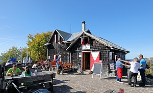
The Otto Kandler House right on the summit |
||
The Hohenstein ( 1195 m above sea level ) is a mountain in the Türnitz Alps in Lower Austria .
Location and name
The Hohenstein rises about six kilometers north of the market town of Türnitz . The border between the municipalities of Lilienfeld and Kirchberg an der Pielach runs over its summit, which also forms the border between the districts of Lilienfeld and Sankt Pölten-Land . With its mostly steep forest flanks, the Hohenstein clearly towers over the surrounding valleys. To the northwest it forms a pronounced rock wall. It can also be seen from the Pielach valley and gave the mountain its name.
The overall good view from Hohenstein is most impressive to the west and north-west. On a clear day it extends from the Waldviertel over the Danube to the Ötscher and the Toten Gebirge .
Otto Kandler House
Immediately next to the summit cross is the Otto-Kandler-Haus , a refuge of the St. Pölten section of the Austrian Alpine Association . It is open from May to October on weekends and public holidays and offers 25 beds in the camp. The hut was built in 1905 and later expanded. In 2007 it was the first Alpine club hut in Lower Austria to receive the ÖAV's environmental seal of approval.
With its hut that has been around for over 100 years, the Hohenstein is a hiking destination with tradition. Nevertheless, its surroundings today have the character of an emphatically calm and relaxing low mountain range.
Ascents
The Hohenstein can be reached on a number of marked trails. They are consistently easy , but at the same time have considerable differences in altitude due to the starting point in the valleys.
- from the Schöngraben farmstead via the Schöngrabenspitze and the Ebenwiesen , finally on the steep Tradigister Steig . Walking time: 2 to 2½ hours
- from Zögersbach via Engleitengraben and Engleitensattel , walking time: 2 to 2½ hours
- from Zögersbach via the Himmelalm and the Engleitensattel ( high- altitude hike with great views ), walking time: around 3 hours
- from the Raxenböck farmstead northeast of Türnitz on long-distance hiking trail no.06 , walking time: around 3 hours
- from the rear of the Soistal via the former Löbelgraben property , walking time: 2 to 2½ hours
- from the rear of the Soistal via Schöngrabenspitze and Ebenwiesen , walking time: 2½ to 3 hours.
The transition to the Julius-Seitner-Hütte on the Eisenstein is possible via the Gscheid in about 3½ hours.
In winter, the wooded surroundings of the Hohenstein are better suited for snowshoeing than for ski tours .
literature
- Franz Hauleitner: Ötscher. Mariazell - Türnitz - Traisentaler Berge , Bergverlag Rudolf Rother , Munich 2010, 4th edition. ISBN 978-3-7633-4026-2
- Adi Mokrejs: Bergwanderatlas Niederösterreich , Schall-Verlag, Alland 2012, 2nd edition. ISBN 978-3-900533-66-3
Web links
- Hiking tip from the daily newspaper "Der Standard", September 1st, 2012
- More detailed information on the Otto Kandler House


