Eisenstein (Alps)
| Eisenstein | ||
|---|---|---|
|
Türnitz and Eisenstein from the southeast (ascent to the Türnitzer Höger ) |
||
| height | 1185 m above sea level A. | |
| location | Lower Austria , Austria | |
| Mountains | Türnitz Alps | |
| Dominance | 5.2 km → Hohenstein | |
| Notch height | 317 m ↓ Gscheid | |
| Coordinates | 47 ° 57 '36 " N , 15 ° 26' 25" E | |
|
|
||
| Normal way | Hike | |
|
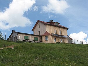
Julius Seitner Hut on the Eisenstein |
||
The Eisenstein ( 1185 m above sea level ) is a mountain in the Türnitz Alps in southern Lower Austria . The Julius-Seitner-Hütte of the Austrian Mountain Association stands on its summit .
location
The area around the Eisenstein is located in the communities of Schwarzenbach an der Pielach , Loich and Türnitz . The closest, higher mountain is the Hohenstein ( 1195 m above sea level ) in the northeast. From the summit you can see the Ötscher , the Schneeberg or the Gippel as well as the Großer Priel , the Traunstein and the mountains of the Bohemian Forest .
Ascents
- from Türnitz, 466 m above sea level. A. , about 2½ hours of walking
- from Hochgraser ( Türnitz ), 690 m above sea level. A. , about 1½ hours of walking
- from Knedelhof (Türnitz), 595 m above sea level. A. , about 1½ hours of walking
- from Stelzerbach (Türnitz), about 2¾ hours walking time
- from Dobersnigg (Loich station), 400 m above sea level. A. , about 3 hours of walking
- from Loicheck , 878 m above sea level A. , about 1.5 hours walking time
- from Schwarzenbach an der Pielach (town center), 510 m above sea level. A. , about 2 hours of walking
Several regional and Austrian long-distance hiking trails lead over the summit of the Eisenstein.
The transition to the Otto-Kandler-Haus on the Hohenstein is possible via the Gscheid in about 3 hours.
In winter, the Eisenstein is popular as a destination for simple ski tours , with the Knedelhof being the cheapest starting point. Its terrain is also well suited for snowshoe hikes . The Paulinenhöhle, about three kilometers southeast of its summit, is worth a visit.
Web links
literature
- Franz Hauleitner: Ötscher. Mariazell - Türnitz - Traisentaler Berge , Bergverlag Rudolf Rother , Munich 2010, 4th edition. ISBN 978-3-7633-4026-2
- Adi Mokrejs: Bergwanderatlas Niederösterreich , Schall-Verlag, Alland 2012, 2nd edition. ISBN 978-3-900533-66-3
Individual evidence
- ↑ Der Standard , September 1, 2003: Pure nature on the Eisenstein
- ↑ www.bergstieg.com: Eisenstein-Südabfahrt
- ↑ www.bergnews.com: Eisenstein - Paulinenhöhle


