Holle sand
|
Holle sand
|
||
| location | Northwest of Remels , Leer district , Lower Saxony | |
| surface | 126 hectares | |
| Identifier | NSG WE 105 | |
| WDPA ID | 81920 | |
| Geographical location | 53 ° 20 ' N , 7 ° 43' E | |
|
|
||
| Sea level | from 8 m to 19 m | |
| Setup date | October 20, 1951 | |
| administration | NLWKN | |
The Holle Sand is a nature reserve in the Lower Saxony municipality of Uplengen in the district of Leer .
The nature reserve with the registration number NSG WE 105 is around 126 hectares in size. It has been a nature reserve since October 20, 1951. The responsible lower nature conservation authority is the district of Leer.
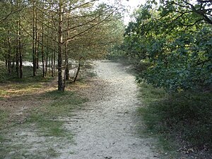
The nature reserve is located northwest of Remels . It is the largest glacial inland dunes area Ostfrieslands under protection. Within the nature reserve lies the Kugelberg, the highest natural elevation in East Frisia. The area is predominantly overgrown by pine forest, partly there is also birch-oak forest .
Several hiking trails run through the nature reserve. In the west, the nature reserve borders on Kreisstraße 10.
Web links
- Nature reserve "Holle Sand" in the database of the Lower Saxony State Office for Water Management, Coastal and Nature Conservation (NLWKN)
Individual evidence
- ↑ forest and heath area Holle sand , Ostfriesland Travel. Retrieved April 1, 2020.
- ↑ Hiking trails in the "Hollesand" nature reserve , Wilhelmshaven Touristik & Freizeit. Retrieved April 1, 2020.
- ↑ Hollesand viewpoint , GeoLife.de-Navigator, State Office for Geoinformation and Land Surveying Lower Saxony (LGLN). Retrieved April 1, 2020.


