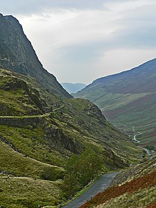
Honister Pass
| Honister Pass | |||
|---|---|---|---|
|
The Honister Pass in the direction of Buttermere |
|||
| Compass direction | west | east | |
| Pass height | 356 m | ||
| county | Cumbria | ||
| Watershed | Gatesgarthdale Beck | River Derwent | |
| Valley locations | Gatescarth Farm | Seatoller | |
| expansion | Pass road | ||
| profile | |||
| Ø pitch | 8.1% (243 m / 3 km) | 7.9% (238 m / 3 km) | |
| Max. Incline | 13% (on km 3) | 13.8% (on km 2) | |
| Map (Cumbria) | |||
|
|
|||
| Coordinates | 54 ° 30 ′ 42 ″ N , 3 ° 12 ′ 0 ″ W | ||
The Honister Pass or Honister Home is a mountain pass in the Lake District , Cumbria , England .
The pass lies at an altitude of 356 m and connects the hamlet of Seatoller in Borrowdale in the east with the hamlet of Gatesgarthdale on Buttermere Lake in the west. The pass road has a gradient of up to 25 percent.
The pass is bounded by the Gray Knotts to the south and Dale Head to the north.
The Gatesgarthdale Beck is formed on the Honister Pass and flows west to Buttermere Lake.
On the pass is the Honister home youth hostel and the slate quarrying of the Honister Slate Mine .
In the 24 hours from December 4 to 5, 2015, at 6 p.m., the Honister Pass measured 341.4 mm, the highest daily rainfall recorded in Cumbria to date.
Individual evidence
- ↑ At least one person killed in floods as 45,000 homes remain without power in: The Guardian , December 7, 2015, accessed December 7, 2015
Web links
- Honister Pass on The Cumbrian Directory
- Honister Pass on Visit Cumbria
- Honister home youth hostel on Hosteling International

