Hornweidbach
| Hornweidbach | ||
|
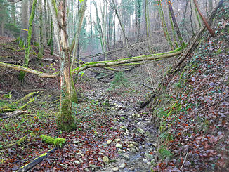
Hornweidbach near the source directly before the confluence of the left branch |
||
| Data | ||
| Water code | CH : ZH100389 | |
| location | Switzerland | |
| River system | Rhine | |
| Drain over | Lunnerenbach → Reppisch → Limmat → Aare → Rhine → North Sea | |
| source | at the Reutetal farm , Aesch 47 ° 20 ′ 22 ″ N , 8 ° 25 ′ 33 ″ E |
|
| Source height | approx. 583 m above sea level M. | |
| muzzle | near Vorderaltenberg in the Lunnerenbach coordinates: 47 ° 20 '47 " N , 8 ° 25' 21" E ; CH1903: 674 340 / 244412 47 ° 20 '47 " N , 8 ° 25' 21" O |
|
| Mouth height | 506 m above sea level M. | |
| Height difference | approx. 77 m | |
| Bottom slope | approx. 84 ‰ | |
| length | 920 m | |
| Catchment area | approx. 40 ha | |
| Communities | Aesch , Birmensdorf | |
|
The stream near the mouth at Schauber |
||
The Hornweidbach is a 920 meter long right tributary of the Lunnerenbach in the communities of Aesch and Birmensdorf in the canton of Zurich . It drains a small section in the center of the Holzbirrliberg hill range.
The brook is first mentioned as Reuenthaler bächli on August 14, 1562 when the opening of Birmensdorf was renewed . He formerly sprang from Reuent (h) al -called Ried , which was drained to the 1920s. During the total amelioration of the community of Aesch in the 1940s, several drainage pipes were laid in the headwaters, which today mainly feed the stream. In the 1950s, the Reutetal farm followed , which is where the reed is today. Even today, the surrounding fields, mainly soil type Pseudogley - brown earth possess influenced by backwater and partly to the surface pore saturated.
geography
course
The Hornweidbach arises today overturned at about 583 m above sea level. M. at the confluence of two drainage lines directly at the Reutetal farm on the Holzbirrliberg hill range, a little southeast of the Altenberg ( 599 m above sea level ). The headwaters lie south of the Horn between the valley of the Aescherbach in the east and the Gruenhaldentobel of the Lunnerenbach in the west.
After running around 70 meters, the brook comes to the surface for the first time in a broad strip of forest protruding to the southeast. The forest area, formerly known as Altenbergerholz , is bordered in the east by the Hornweid, which gives it its name, and in the south by the fields in the Reutetal . He maintains the course and at the same time forms a ravine . After the confluence with its left branch, it flows north, digging into the eastern slope of the Altenberg .
The Hornweidbach crosses the municipal boundary to Birmensdorf, where it turns again to the northwest and now flows through the Cholholz . It finally flows into Schauber a little south of Vorderaltenberg at 506 m above sea level. M. from the right and south in the middle course of the Lunnerenbach.
Web links
- Course of the Hornweidbach on GIS Zurich
- Course of the Hornweidbach on the geoserver of the Swiss federal administration
swell
Individual evidence
- ↑ a b c individual records of the geographic information system of the canton of Zurich
- ↑ a b c Geoserver of the Swiss Federal Administration ( information )
- ↑ Renewal of the opening. (PDF) In: The legal sources of the Canton of Zurich, Part One: Openings and Court Rights, Volume Two: Bertschikon to Dürnten. Retrieved October 1, 2018 .


