Horst (Vogelsberg)
| horst | ||
|---|---|---|
|
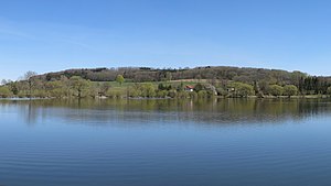
View from the northwest over the Nieder-Mooser pond to the eyrie |
||
| height | 553.3 m above sea level NHN | |
| location | Vogelsbergkreis , Hoher Vogelsberg Nature Park , Hesse , Germany | |
| Mountains | Vogelsberg | |
| Dominance | 2 km → Naxburg | |
| Notch height | 38 m | |
| Coordinates | 50 ° 28 ′ 1 ″ N , 9 ° 24 ′ 7 ″ E | |
|
|
||
| rock | basalt | |
The Horst is a 553.3 u m. NHN high elevation in Vogelsberg , Hesse , Germany .
The mountain lies between Gunzenau and Nieder-Moos , two districts of Freiensteinau, 4.5 kilometers north of the core community. 1.5 kilometers west of the mountain is the 30 hectare Nieder-Mooser pond.
On the eyrie there are three radio antennas and a cemetery with a chapel, to which a paved and public road from Gunzenau leads up. The north and west slopes of the mountain are densely forested, whereas the other slopes and the approximately 500 m long summit ridge have no or sparse tree growth. The eyrie allows a view to the east as far as the Rhön . In the west, the view extends over the Ober- and Nieder-Mooser ponds to the Herchenhainer Höhe and on very clear days to the Großer Feldberg im Taunus .


