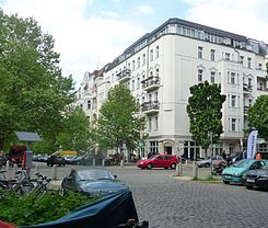
Hufelandstrasse
| Hufelandstrasse | |
|---|---|
| Street in Berlin | |
| Look at Hufelandstraße corner Bötzowstraße |
|
| Basic data | |
| place | Berlin |
| District | Prenzlauer Berg |
| Created | in the 19th century |
| Connecting roads |
Marienburger Strasse , Virchowstrasse |
| Cross streets |
Esmarchstrasse , Bötzowstrasse , Hans-Otto-Strasse |
| use | |
| User groups | Pedestrian traffic , bicycle traffic , car traffic |
| Technical specifications | |
| Street length | 650 meters |
The Hufelandstraße is located in the Berlin district of Prenzlauer Berg of Pankow . It is located in the Bötzowviertel , not far from the Volkspark Friedrichshain and on the border to the Friedrichshain-Kreuzberg district . The street leads from Greifswalder Strasse in the northwest to Strasse Am Friedrichshain in the southeast. The street with numerous neighboring traffic routes was created in the 19th century as a residential area for the rapidly growing Berlin population. After 1990 it was extensively renovated and now offers the ambience of the Prenzlauer Berg district with numerous smaller shops, restaurants and cafes.
history
For the first installation according to the Hobrecht Plan, Section XIII / 1, it was Street 2 . On June 4, 1904 she was named after Christoph Wilhelm Hufeland (1762-1836), the personal physician of Friedrich Wilhelm III. , named. Hufeland had worked tirelessly to improve the hygienic conditions in Berlin and is considered one of the founders of macrobiotics .
The architecture of the street is characterized by residential buildings from the Wilhelminian era , which are characterized by numerous balconies and bay windows . The buildings were built between 1900 and 1910. The western part of the Hufelandstraße survived the air raids and fighting of the Second World War largely unscathed, the eastern part suffered losses and was rebuilt. In the course of the following decades, however, the money to maintain the residential buildings was lacking because the creation of new living space in the districts of Marzahn and Hellersdorf had priority.
The restoration of the buildings began after the political change in the early 1990s and initially concentrated on upgrading the facades . When the Bötzowviertel was declared a redevelopment area in 1995 , the modernization of the apartments began and numerous attics were built. Until the mid-1980s there had been old linden trees as high as a house in the street , but they fell ill after the switch to natural gas and had to be felled. After the renovation of the gas pipelines in 1990, trees could be planted again, this time plane trees as new street trees . Only on the northern sidewalk between Bötzowstrasse and Greifswalder Strasse were the planters from the GDR that were set up to compensate for the felled linden trees . This section was renovated at the beginning of 2008 and plane trees were also planted here.
The last gap in houses No. 34 to be designated as a building plot was closed in 2007. The corner lot on Hans-Otto-Straße was converted into a playground.
The Hufelandstraße is a paved road. It can be bypassed via Greifswalder Straße , Am Friedrichshain and Danziger Straße . Within the Bötzowviertel, however, it is the most heavily traveled street, especially the section between Greifswalder Straße and Bötzowstraße.
In the mid-2000s, there was strong gentrification due to the attractive residential area.
literature
- Andreas Wenderoth and Joachim Gauck with photos by Harf Zimmermann: Germany, how are you united? Cover story: Hufelandstraße - Today without yesterday. Germany in close-up: the metamorphosis of a Berlin street in two decades of reunification. In: GEO Magazin , No. 10, October 2010.
- Lea Streisand: Life in the GDR: We children from Hufelandstrasse , In: Berliner Zeitung , April 23, 2017
Web links
- Hufelandstrasse. In: Street name lexicon of the Luisenstädtischer Bildungsverein (near Kaupert )
- Images and texts on the history of Hufelandstrasse by Harf Zimmermann and Hans-Otto Bredendiek
- The Hufelandstrasse - 1987 and 2010. In: Der Tagesspiegel , October 3, 2010, photo gallery
Individual evidence
- ↑ Kerstin Lindstädt on the website of the Pankow district office of Berlin: Berlin-Pankow from the local history and building history , Berlin 2010, p. 71.
Coordinates: 52 ° 31 '53 " N , 13 ° 25' 59" E
