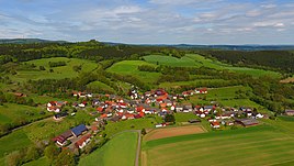
Ibra (upper auditorium)
|
Ibra
Community Oberaula
Coordinates: 50 ° 49 ′ 35 ″ N , 9 ° 29 ′ 37 ″ E
|
|
|---|---|
| Height : | 317 (310-332) m |
| Area : | 6.81 km² |
| Residents : | 135 (December 31, 2016) |
| Population density : | 20 inhabitants / km² |
| Incorporation : | 1st January 1974 |
| Postal code : | 36280 |
| Area code : | 06628 |
|
Ibra from above
|
|
Ibra is the smallest part of the municipality Oberaula in the north Hessian Schwalm-Eder district . The village is dominated by agriculture.
geography
Ibra is located almost four kilometers south-southeast of the Oberaulaer core town in the southern foothills of the Knüll Mountains . The highest point near Ibra is the Ibrakuppe to the north-northeast ( 486.9 m above sea level ), which can be reached via hiking trails and offers a distant view of over one hundred kilometers. The upper reaches of the Ibra flow through the village . State road 3294 ( Hausen –Ibra– Machtlos ) leads through it ; From this, the county road 129 branches off southeast of the village , which leads east to Kemmerode .
history
Ibra is first mentioned in 1195 as "Äwera". In 1325 the place appears as "Ibra" and in 1327 as "Ibera".
On 1 January 1974 Ibra was in the course of administrative reform in Hesse powerful state law with the previously independent municipalities Oberaula, Friedigerode, Olberode and Wahlhausen for new large municipality Oberaula together . Local districts were formed for all formerly independent communities .
Ibra was named " Dolles Dorf " in 2012.
Individual evidence
- ↑ Numbers and facts. In: Internet presence. Oberaula municipality, archived from the original on August 4, 2018 ; accessed in October 2018 .
- ↑ Law on the reorganization of the districts Fritzlar-Homberg, Melsungen and Ziegenhain (GVBl. II 330-22) of September 28, 1973 . In: The Hessian Minister of the Interior (ed.): Law and Ordinance Gazette for the State of Hesse . 1973 No. 25 , p. 356 , § 6 ( online at the information system of the Hessian state parliament [PDF; 2,3 MB ]).
- ^ Federal Statistical Office (ed.): Historical municipality directory for the Federal Republic of Germany. Name, border and key number changes in municipalities, counties and administrative districts from May 27, 1970 to December 31, 1982 . W. Kohlhammer, Stuttgart / Mainz 1983, ISBN 3-17-003263-1 , p. 413 .
literature
- Literature on Ibra in the Hessian Bibliography
- Search for Ibra (Oberaula) in the archive portal-D of the German Digital Library
Web links
- Ibra district on the Oberaula website.
- Ibra, Schwalm-Eder district. Historical local dictionary for Hessen. In: Landesgeschichtliches Informationssystem Hessen (LAGIS).

