
Ierapetra
|
Municipality of Ierapetra Δήμος Ιεράπετρας |
|||
|---|---|---|---|
|
|||
| Basic data | |||
| State : |
|
||
| Region : | Crete | ||
| Regional District : | Lasithi | ||
| Geographic coordinates : | 35 ° 0 ′ N , 25 ° 44 ′ E | ||
| Area : | 470.150 km² | ||
| Residents : | 26,200 (2011) | ||
| Population density : | 55.7 inhabitants / km² | ||
| Community logo: |
 |
||
| Seat: | Ierapetra | ||
| LAU-1 code no .: | 7202 | ||
| Districts : | 2 parishes | ||
| Local self-government : |
1 city district 13 local communities |
||
| Website: | www.ierapetra.gr | ||
| Location in the Crete region | |||
 |
|||

Ierapetra ( Greek Ιεράπετρα ( f. Sg. )) Is a city in the southeast of the Greek Mediterranean island of Crete and the administrative center of the municipality of the same name ( Greek Δημος , Dimos ). It is the southernmost city in Europe (excluding Cyprus, which geographically belongs to Asia). Ierapetra is located on the narrowest part of Crete: From the south to the north coast it is only 12 kilometers as the crow flies.
With 12,355 inhabitants in the city center and 16,139 as a district together with the connected suburbs, Ierapetra is the fourth largest city on the island and the largest of the Lasithi regional district , the former Lasithi prefecture. After the municipal reform according to the Kallikratis Act 2010, the former municipalities and current municipal districts of Ierapetra and Makrys Gialos formed the entire municipality of Ierapetra. In November 2011 four of the local communities of Makrys Gialos were moved to the neighboring municipality of Sitia . The municipality of Ierapetra has 26,200 inhabitants (according to the 2011 census).
geography
Community structure
The parish of Ierapetra is divided into two parishes; As a local representation below the community level, there is a city district and 16 local communities. The following table also shows settlements with more than 400 inhabitants (population figures from the results of the 2011 census).
|
|
climate
The prevailing climate of the landscape around Ierapetra is one of the warmest in Crete. The heat in the city is often mitigated in summer by the sometimes stormy north wind ( Boreas ), which is particularly pronounced at the narrow point of Crete.
|
Average monthly temperatures and rainfall for Ierapetra
|
|||||||||||||||||||||||||||||||||||||||||||||||||||||||||||||||||||||||||||||||||||||||||||||||||||||||||||||||||||||||||||||||||||||||||||||||||||||||||||||||||||||||||||||||||||||||||||||||||||||||||||||||||||||||||||||||||||||||||||||||||||||||||||||||
history
In ancient times the city was called Hierapytna . The earliest remains of the city date back to the fifth century BC. They gained dominance over the south-eastern region of Crete; this heyday lasted until the conquest in 67 BC. By the Romans . The Roman villa of Makrygialos dates from this period .
During the conquest by the Arabs in 824, the city was badly destroyed, but then rebuilt. It experienced a new period of bloom in the Venetian era from the 13th to the 17th century - since then it has been called Ierapetra. In 1798 Napoléon Bonaparte is said to have stopped in Ierapetra on his campaign to Egypt . The house in which he supposedly stayed the night is still shown today.
Worth seeing in Ierapetra are the Venetian fort from 1626 (at the harbor), the Agios Georgios church in the city center (1856) and a partly dilapidated Turkish mosque with the restored minaret and fountain house.
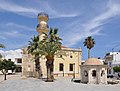
The ruined Turkish mosque with the restored minaret

Napoleon's house
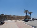
The Venetian Castle


Sustainable tourism
In 2012, Ierapetra was awarded the QualityCoast Gold award for special efforts in sustainable development. Therefore, Ierapetra has been included in the global sustainable tourism atlas, DestiNet .
economy

Ierapetra has a port that is used for pleasure craft and fishing. In the area around Ierapetra, vegetable growing (tomatoes, peppers, cucumbers, beans) - also in foil tents - is the main occupation. The Bramiana reservoir near Gra Ligia, northwest of Ierapetra, provides the required water . A regional airport is under discussion. The region supplies large parts of Greece with fresh vegetables. Its transport by road to Heraklion is increasingly burdening the farmers with rising prices, so alternatives are being sought.
Tourism companies still make up the smaller but growing proportion of commercial operations here. The beach / shore promenade set up for tourists is the first step in the development of tourism, which has so far grown very tentatively and therefore environmentally friendly in the south-eastern region of Crete. From Ierapetra in summer tourist boats go to the uninhabited islands of Chrysi , which administratively also belongs to the municipality of Ierapetra, and Koufonisi (municipality of Sitia ).
Individual evidence
- ↑ a b c Results of the 2011 census at the National Statistical Service of Greece (ΕΛ.ΣΤΑΤ) ( Memento from June 27, 2015 in the Internet Archive ) (Excel document, 2.6 MB)
- ↑ Greek government newspaper 239A 2011, PD 105, November 9, 2011 (PDF online) ( Memento of the original from May 4, 2015 in the Internet Archive ) Info: The archive link was automatically inserted and not yet checked. Please check the original and archive link according to the instructions and then remove this notice.
- ↑ Sustainable Tourism Destination EUCC ( Memento of the original from September 18, 2016 in the Internet Archive ) Info: The archive link was inserted automatically and has not yet been checked. Please check the original and archive link according to the instructions and then remove this notice. (PDF; 13.0 MB)