
Ignalin (Lidzbark Warmiński)
| Ignalin | |||
|---|---|---|---|
 Help on coat of arms |
|
||
| Basic data | |||
| State : | Poland | ||
| Voivodeship : | Warmia-Masuria | ||
| Powiat : | Lidzbarski | ||
| Gmina : | Lidzbark Warmiński | ||
| Geographic location : | 54 ° 9 ' N , 20 ° 29' E | ||
| Residents : | |||
| License plate : | NLI | ||
| Economy and Transport | |||
| Next international airport : | Danzig | ||

Ignalin ( German Reimerswalde ) is a village in the rural community Lidzbark Warmiński (Heilsberg) in the Powiat Lidzbarski in the Polish Warmian-Masurian Voivodeship .
Geographical location

The village is located in the historical region of East Prussia , about seven kilometers northwest of Heilsberg ( Lidzbark Warmiński ) and 70 kilometers south of Königsberg .
history


In 1945, the farming village Reimer forest for part circle Heilsberg in the administrative district of Konigsberg the Prussian province of East Prussia of the German Reich .
Towards the end of the Second World War , the region was occupied by the Red Army in the spring of 1945 . After the end of the war, Reimerswalde was placed under Polish administration by the Soviet occupying power in accordance with the Potsdam Agreement, along with the southern half of East Prussia and all of West Prussia . The Poles introduced the place name Ignalin for Reimerswalde . Unless the local villagers had fled, they were subsequently driven out .

Onion dome of the village church
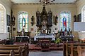
Altar of the village church
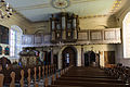
Entrance side of the nave
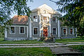
Historic rectory


Today the village forms a Schulzenamt within the Gmina Lidzbark Warmiński in the Powiat Lidzbarski within the Warmian-Masurian Voivodeship (1975 to 1998 Olsztyn Voivodeship ).
Demographics
| year | Residents | Remarks |
|---|---|---|
| 1816 | 188 | |
| 1852 | 660 | |
| 1858 | 660 | exclusively Catholics |
| 1910 | 619 | |
| 1933 | 624 | |
| 1939 | 633 |
Parish
Before 1945, the majority of the Catholic residents of Reimerswalde belonged to the Reimerswalde parish in the Diocese of Warmia , while the Protestant part of the population was assigned to the Heilsberg parish in the Braunsberg parish within the church province of East Prussia of the Church of the Old Prussian Union .
The local Catholic church members now belong to the Lidzbark Warmiński deanery in the Archdiocese of Warmia of the Catholic Church in Poland . The Protestant church members today belong to the Masurian diocese of the Evangelical Lutheran Church in Poland .
Web links
- Reimerswalde district (Rolf Jehke, 2012)
Individual evidence
- ↑ Alexander August Mützell and Leopold Krug : New topographical-statistical-geographical dictionary of the Prussian state . Volume 4: P – S , Halle 1823, p. 130, item 1069.
- ^ Kraatz: Topographical-statistical manual of the Prussian state . Berlin 1856, p. 504.
- ↑ Adolf Schlott: Topographical-statistical overview of the government district of Königsberg, based on official sources . Hartung, Königsberg 1861, p. 112, paragraph 109.
- ↑ http://gemeindeververzeichnis.de/gem1900//gem1900.htm?ostpreussen/heilsberg.htm
- ↑ a b Michael Rademacher: German administrative history from the unification of the empire in 1871 to the reunification in 1990. Heilsberg.html. (Online material for the dissertation, Osnabrück 2006).