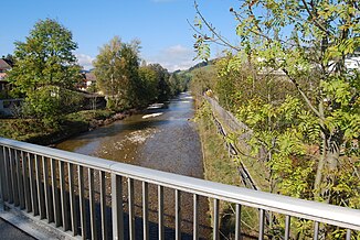
Ilfis
The Ilfis (in the local dialect : [ (d̥) ˈʏu̯fiz̥ / ˈɪu̯fiz̥ ]) is an approximately 25 km long tributary of the Emme in the upper Entlebuch and in the upper Emmental .
Names
The oldest evidence of the name comes from the year 1337 ( Büelgůt ... in Rosverrich zủr Ilvis ; Johannis zủr Ilvis ) and relates either to the village of Ilfis near Langnau or to the Enedilfis farms in the municipality of Escholzmatt . Ilfis appears as the name of the waterway from 1371 ([cop. 1531] Since the kennell In the Ilvis gatt and over Iluis Inn the müllibach ... the kennel brook back down into the Iluis ; [cop.] And ir quite fanned because the Kenelbach into the Ilfis gat and via Ilfis into the Mülibach ... and the Kenelbach down again into the Ilfis ).
The origin of the name is not entirely certain. It could be based on a derivation * Elvis (i) ā from the Gallic color root * elvo- 'brown, yellow', which probably indicates the yellow tint of the water. The term help is apparently associated with this name .
geography
course
The Ilfis rises below the Hengst on the western slope of the Schrattenfluh and flows northwards from there. At Dorbachholtz, it pours into the westward aid , which after its union with the Schonbach bears the name Ilfis again. The river, which initially runs north again, turns more towards the west at Wiggen and forms the border between the cantons of Lucerne and Bern from Kröschenbrunnen to the confluence of the Hämelbach . In its further course the Ilfis passes Trubschachen , Bärau and Langnau in the Emmental and flows into the Emme from the right at Emmenmatt .
Tributaries
- Wooden grave ( right )
- Hilferenbach ( right )
- Rischhusgrabe ( right )
- Häzeswandgraben ( left )
- Buhüttegrabe ( left )
- Schonbach ( left )
- Rotbach ( right )
- Staldengraben ( right )
- Wittenmoosgraben ( left )
- Rämisbach ( right )
- Äschlisbach ( right )
- Turnhaldebach ( right )
- Stierenweidgraben ( right )
- Lauelibach ( right )
- Schärligbach ( left )
- Gummegraben ( left ), 3.2 km
- Rütigraben ( left ), 0.9 km
- Rappenästgrabe 2 ( left ), 0.5 km
- Dürenbachgraben ( right )
- Rappenästgrabe 1 ( left ), 1.0 km
- Hämelbach ( right ), 4.5 km
- Hogergrabe ( left ), 0.2 km
- Stärenegg ( left ), 0.5 km
- Hagleregrabe ( left ), 0.4 km
- Lüfteligräbli ( right ), 0.9 km
- Steibach ( left ), 3.2 km
- Buechraingräbli ( right ), 0.3 km
- Kamblybach ( right ), 0.3 km
- Sagibach ( right ), 0.7 km
- Trueb ( right ), 8.6 miles
- Chrümpelgrabebach ( left ), 4.5 km
- Haseleegräbli ( right ), 0.9 km
- Front Zueloufgräbli ( right ), 0.5 km
- Bäregghöchigräbli ( right ), 0.4 km
- Ortbachgrabe ( left ), 2.2 km
- Teufebachgrabe ( left ), 2.7 km
- Ramseregrabe ( left ), 2.3 km
- Burspu grave ( left ), 0.7 km
- Burspu grave ( left ), 0.9 km
- Gohl ( right ), 11.3 km
- Hüenerbach ( left ), 3.0 km
- Widerberggräbli ( right ), 0.3 km
- Öffelgrabe ( right ), 1.0 km
- Nidermoosgrabe ( left ), 0.8 km
- Mülibach ( left ), 1.6 km
- Wintersitegräbli ( left ), 0.6 km
- Schützegrabe ( right ), 1.6 km
- Ilfisgrabe ( left ), 1.8 miles
- Dorfberggrabe ( right ), 1.0 km
- Obere Frittebach ( right ), 7.6 km
- Ziegelhüttegrabe ( right ), 0.4 km
- Hübeligrabe ( right ), 0.5 km
- Renzegrabe ( left ), 0.8 km
- Renzegrabe ( left ), 0.7 km
- Hüselmattgräbli ( right ), 0.4 km
- Übersrütigräbli ( right ), 1.0 km
Individual evidence
- ↑ a b c d Geoserver of the Swiss Federal Administration ( information )
- ↑ Measuring station Langnau 2013 (PDF) Federal Office for the Environment FOEN
- ↑ Modeled mean annual discharge. In: Topographical catchment areas of Swiss waters: area outlets. Retrieved November 2, 2015 .
- ↑ a b Erika Waser, Lucerne name book 1,1: Entlebuch. The place and field names of the Entlebuch office (A – L), Comenius, Hitzkirch 1996, ISBN 3-905286-56-4 , p. 484f.
- ↑ Erika Waser, Lucerne name book 1.1: Entlebuch. The place and field names of the Entlebuch office (A – L), Comenius, Hitzkirch 1996, ISBN 3-905286-56-4 , p. 430f.


