
Innerthal
| Innerthal | |
|---|---|
 |
|
| State : |
|
| Canton : |
|
| District : | March |
| BFS no. : | 1343 |
| Postal code : | 8858 |
| Coordinates : | 712 335 / 218200 |
| Height : | 915 m above sea level M. |
| Height range : | 835–2294 m above sea level M. |
| Area : | 50.14 km² |
| Residents: | 173 (December 31, 2018) |
| Population density : | 3 inhabitants per km² |
|
Proportion of foreigners : (residents without citizenship ) |
4.1% (December 31, 2,015) |
| Website: | www.innerthal.ch |
 Innerthal |
|
| Location of the municipality | |
  |
|
Innerthal is a municipality in the March district in the canton of Schwyz in Switzerland .
coat of arms
The Rossalpelispitz and the Zindlenspitz are shown on the coat of arms of Innerthal . The yellow sun stands on a red background above the two mountains. At the foot of the mountains, the Wägitalersee can be seen in blue; the two mountains are silver.
geography

Innerthal is a mountain community in Wägital . It lies in a basin surrounded by Gross Aubrig , Fluebrig , Mutteristock (also the highest point in the municipality at 2294 m above sea level ) and Brünnelistock , on the northeastern bank of the Wägitalersee . In the east, the municipality border is also the Schwyz canton border to the neighboring canton of Glarus . In the south, a corner of the municipality pushes itself over the Pragel pass road. Around a third of the area of the municipality is forest, agricultural area or unproductive mountainous landscape. The Zindelenhöhle is in the community area .
population
| Population development | |
|---|---|
| year | Residents |
| 1850 | 302 |
| 1900 | 320 |
| 1950 | 210 |
| 1970 | 184 |
| 1990 | 157 |
| 2000 | 176 |
| 2010 | 199 |
politics
The two most important parties SVP and CVP are roughly equally strong, each with a good 40% share of the vote.
economy
In addition to mountain farming, restaurants and fishing, only the power plant operator AG Kraftwerk Wägital offers some jobs. Half of the employees work outside the community, mostly in March .
history

The Katharina Chapel in Wägital was first mentioned in a document in 1397.
In 1480 the separation from Tuggen took place and the Wägital became politically independent. The outbreak of the plague of 1629 claimed more than 350 victims, over half of the valley inhabitants; there were mass graves created.
Innerthal and Vorderthal separated in 1776.
The road into Wägital was built in 1860. Together with the start of operations in the new spa hotel on the lake in the following year, Innerthal experienced an upswing. From 1894 the federal horse mail drove to Wägital and electricity was first delivered in 1908.
From 1922 to 1925 the Wägitalersee was dammed with a 111 m high wall. Its construction marked a turning point in its history for Innerthal: 369 inhabitants lived here in 1920. Well over 100 people had to leave the community, and in 1930 only 223 people lived here. Only in some of the homes could the homes be moved to higher altitudes. The old village church was blown up before the flooding and a new building was built in the new village center.
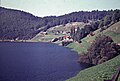
Attractions
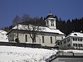
Church in winter

View of the church and the lake in summer
View along the road by the lake to Innerthal in the summer of 1956


Arts and Culture
A Sennenchilbi takes place in Innerthal on the 2nd Sunday in September . This very old and ancient event is organized by the Sennenbruderschaft, founded in 1598 .
literature
- Linus Birchler : The art monuments of the canton Schwyz, Volume I: The districts of Einsiedeln, Höfe and March. (= Swiss art monuments. Volume 1). Edited by the Society for Swiss Art History GSK. Bern 1927.
- Hans Bernhard: The Wäggital resettlement plant . Assessment. Rascher, Zurich 1921.
- Lenz Mächler: The Bad Wäggithal , on the history of the former spa town of Innerthal (1862-1924). In: Schwyzer Hefte No. 27. Culture Commission of the Canton Schwyz, Schwyz 1983.
- Albert Jörger: The art monuments of the canton Schwyz, Volume 2: The district of March. Edited by the Society for Swiss Art History GSK. Bern 1989 (Art Monuments of Switzerland, Volume 82). ISBN 3-909158-22-6 . Pp. 158-179.
The historical novel by the Swiss writer Beat Hüppin is set in Innerthal. On the basis of historical sources and testimonies, Hüppin tells the fictional story of the Dobler farming family who, like many others, have to give up their homeland because of the flooding.
Web links
- Official website of the municipality of Innerthal
- Josef Wiget: Innerthal. In: Historical Lexicon of Switzerland .
Individual evidence
- ↑ Permanent and non-permanent resident population by year, canton, district, municipality, population type and gender (permanent resident population). In: bfs. admin.ch . Federal Statistical Office (FSO), August 31, 2019, accessed on December 22, 2019 .
- ↑ Archived copy ( Memento of the original dated May 4, 2016 in the Internet Archive ) Info: The archive link was inserted automatically and has not yet been checked. Please check the original and archive link according to the instructions and then remove this notice.
- ^ Zytglogge publishing house