
Iruña de Oca
| Iruña de Oca municipality | |||
|---|---|---|---|

Nanclares de la Oca - town view
|
|||
| coat of arms | Map of Spain | ||
.svg)
|
|
||
| Basic data | |||
| Autonomous Community : |
|
||
| Province : | Álava | ||
| Comarca : | Cuadrilla de Añana | ||
| Coordinates | 42 ° 49 ′ N , 2 ° 49 ′ W | ||
| Height : | 510 msnm | ||
| Area : | 53.25 km² | ||
| Residents : | 3,411 (Jan 1, 2019) | ||
| Population density : | 64.06 inhabitants / km² | ||
| Postal code : | 01230 | ||
| Municipality number ( INE ): | 01901 | ||
| administration | |||
| Website : | Iruña de Oca | ||

Iruña de Oca ( Basque Iruña Oka ) is a northern Spanish municipality in the center of Álava province in the Basque Country, which was founded in 1976 and consists of the main town of Nanclares de la Oca and several villages and hamlets and has a total of 3,411 inhabitants (as of January 1, 2019) . The municipality is located on a branch route of the Way of St. James (Camino Vasco del Interior) .
Location and climate
The municipality extends on both sides of the Río Zadorra at an altitude of about 510 m . The provincial capital Vitoria-Gasteiz is about 18 km (driving distance) to the northeast; the town of Miranda de Ebro in Castile is about 31 km southwest. The climate is temperate to warm; Rain (approx. 830 mm / year) falls over the year.
Population development
| year | 1857 | 1900 | 1981 | 2000 | 2017 |
| Residents | - | - | 2,075 | 1,823 | 3,264 |
Due to the proximity to the provincial capital Vitoria-Gasteiz, the population of the municipality increased significantly at the beginning of the 21st century. The municipality includes the places Nanclares de la Oca , Montevite , Ollávarre , Trespuentes and Villodas .
economy
For centuries, the residents of the community lived on agriculture, self-sufficient , in which cattle breeding played an essential role. Gradually, handicrafts, trade and smaller service companies developed. Today there are smaller commercial settlements at the gates of the main town Nanclares de la Oca .
history
Today's municipality was probably inhabited by Celts . The Romans founded in the 1st century BC BC a Roman road leading from Astorga (Asturica Augusta) to Tarragona (Tarraco) and in its heyday with a population of around 10,000 (today Iruña-Veleia ). Visigoths and Moors left no archaeologically usable traces. In the 9th century the region belonged to the Kingdom of Pamplona , which later became the Kingdom of Navarre . Alfonso VIII of Castile conquered western Navarre around the year 1200, so that the area was Castilian for a long time and belonged to several successive landlord families (señores) .
Attractions


- Nanclares de la Oca
- The originally Romanesque Iglesia de la Asunción de Nuestra Señora is dedicated to the Assumption of Mary ; the building - like the rest of the churches in the region - was built from quarry stone and was raised and vaulted in the 16th century. The bell tower (capanario) seems to come completely from this time. Some windows were made smaller around the middle of the 19th century. Inside the apse there is an imposing baroque altarpiece (retablo)
- The tower, called Calero , probably from the first half of the 19th century and provided with an external staircase, was used by a lime kiln to convert limestone to lime .
- Three signal towers from the late 19th century (Torres Carlistas) are each about 2 km outside the village.
- Montevite
- The Iglesia de San Juan Evangelista is medieval in origin, but it was modernized in the 30s of the 19th century in line with the contemporary taste of neoclassicism . The central, domed rotunda is remarkable.
- Ollávarre
- The Iglesia de San Esteban Protomartir , which is badly angled on the outside, is dedicated to the arch martyr Stephen . Two battlements run above the rear of the nave .
- Trespuentes
- The oldest building in the municipality is very likely (due to its proximity to the Roman city) the 13-arched bridge (Puente Romano) over the Río Zadorra, which - repeatedly repaired - was also used by traders, pilgrims and shepherds for centuries .
- The Gothic Iglesia de Santiago Apóstol is dedicated to the Apostle James the Elder. Ä. consecrated. The south porch (portico) and the upper floor of the tower were added later. There is a baroque altar in the apse.
- In the vicinity of the village are the imposing ruins of the Monasterio de Santa Catalina , which was led one after the other by various orders and finally dissolved in 1835 . The gardens laid out in the 20th century are pretty.
- The ruins of the Roman city of Veleia lie between Trespuentes and Villodas . You can see two floor mosaics with geometric motifs and the foundation walls of several houses.
- Villodas
- The Iglesia de San Cristóbal dates back to the 16th century.
- In Villodas , too , a medieval stone bridge with 10 arches crosses the Río Zadorra.

Nanclares de la Oca - apse of the church
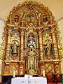
dto. - Altarpiece
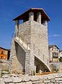
dto. - lime tower

dto. - Carlist tower

dto. - "Fountain of the 12 tubes"

dto. - modern fountain


Web links
Individual evidence
- ↑ Cifras oficiales de población resultantes de la revisión del Padrón municipal a 1 de enero . Population statistics from the Instituto Nacional de Estadística (population update).
- ↑ Nanclares de Oca - climate tables
- ^ Iruña de Oca - population development
- ↑ Iruña de Oca - History
- ↑ Nanclares de la Oca - Church
- ↑ Nanclares de la Oca - Lime Tower
- ↑ Nanclares de la Oca - Carlist Towers
- ↑ Montevite Church
- ↑ Ollávarre - Church
- ↑ Trespuentes - Bridge
- ↑ Trepuentes - Church
- ↑ Trespuentes - monastery ruins
- ↑ Trespuentes - Roman city
- ↑ Villodas - Church
- ↑ Villodas - Bridge
- ↑ Villodas - Bridge
← Previous location: Zalduondo | Iruña de Oca | Next town: Vitoria-Gasteiz →
Alegría de Álava | Amurrio | Añana | Aramayona | Armiñon | Arraya Maestu | Arrazua Ubarrundia | Arceniega | Aspárrena | Ayala | Baños de Ebro | Barrundia | Berantevilla | Bernedo | Campezo | Cigoitia | Cripán | Cuartango | Elburgo | Elciego | Elvillar | Iruña de Oca | Iruraiz-Gauna | Labastida | Lagrán | Laguardia | Lanciego | Lantarón | Lapuebla de Labarca | Leza | Llodio | Moreda de Álava | Navaridas | Oquendo | Oyón | Peñacerrada | Ribera Alta | Ribera Baja | Salvatierra | Samaniego | San Millán | Urcabustaiz | Valdegovía | Valle de Arana | Villabuena de Álava | Villarreal de Álava | Vitoria-Gasteiz | Yécora | Zalduendo de Álava | Zambrana | Zuia