
Valdegovía
| Valdegovía municipality | |||
|---|---|---|---|
 Uribarri Gaubea - town view
|
|||
| coat of arms | Map of Spain | ||

|
|
||
| Basic data | |||
| Autonomous Community : |
|
||
| Province : | Álava | ||
| Comarca : | Cuadrilla de Añana | ||
| Coordinates | 42 ° 51 ′ N , 3 ° 6 ′ W | ||
| Height : | 600 msnm | ||
| Area : | 238.27 km² | ||
| Residents : | 996 (Jan 1, 2019) | ||
| Population density : | 4.18 inhabitants / km² | ||
| Postal code : | 01426 | ||
| Municipality number ( INE ): | 01055 | ||
| administration | |||
| Website : | Valdegovía / Gaubea | ||

Valdegovía ( Basque Gaubea , officially Valdegovía / Gaubea ) is a northern Spanish municipality in the southwest of the province of Álava in the Basque Country, consisting of the main town Villanueva de Valdegovía and around 25 still inhabited hamlets (pedanías) with a total of 996 inhabitants (as of January 1, 2019) .
Location and climate
The densely wooded and hilly, in places even mountainous, large municipality Valdegovía / Gaubea extends on both sides of the central reaches of the Río Omecillo , a northern tributary of the Ebro , at an altitude of approx. 500 to 700 m . The next major city is Miranda de Ebro , about 25 km (by car) south ; the provincial capital Vitoria-Gasteiz is approx. 45 km to the east. The climate is temperate to warm; the rain, which is abundant by Spanish standards (approx. 850 mm / year), falls over the year.
Population development
| year | 1857 | 1900 | 1950 | 2000 | 2017 |
| Residents | 3,728 | 3,005 | 2,916 | 929 | 996 |
As a result of by the mechanization of agriculture farming and the role small businesses triggered reduced demand for workers began a rural exodus , which in turn led to a significant drop in the population of the community since the 1950s. Some of the nearly 30 villages and hamlets have since been completely abandoned ( despoblado ) or are about to do so .
economy
For centuries, the residents of the community lived on agriculture, self-sufficient , in which cattle breeding played an essential role. In the few larger towns, handicrafts, trade and smaller service companies gradually developed. Since the last decades of the 20th century, tourism in the form of renting holiday apartments (casas rurales) has been added as a source of income for the municipality.
history
A few testimonies point to a settlement in the area in prehistoric times. The Celts , Romans , Visigoths and Moors left no archaeologically usable traces. The first traces of Christian settlement date from the early Middle Ages; they come from hermits or shepherds . Since 824 the area belonged to the Kingdom of Pamplona , from which the Kingdom of Navarre later emerged. Alfonso VIII of Castile conquered western Navarre around 1200. At the latest during this time, some of the places were given a Spanish name in addition to their Navarres-Basque name.
Attractions


- Bachicabo
- The single-nave church of San Martín dates back to the 16th century and houses two altarpieces (retablos) .
- Barrio
- The hamlet of Barrio, which still has around 15 inhabitants, is idyllically situated at the end of a side valley.
- Bóveda
- In the hamlet of Bóveda there are the remains of a dolmen and the menhir de Ribota from the time of the megalithic cultures .
- The church of San Vicente dates from the 17th century.
- Bellojín
- The small Romanesque church of San Cornelio y San Cipriano received its bell tower (campanario) only in the 16th century.
- Espejo
- The church of El Salvaldor is also partly Romanesque.
- Gurendes
- The town, which still has around 30 inhabitants, impresses with its location near the border with the province of Burgos in Castile. The bell tower of the church has a later added lantern .
- A house wedged between two streets ends in a semicircular stair tower .
- Karkamu / Carcamo
- The Romanesque portal of the church of Karkamu is covered with a ball-bar ornament.
- Lalastra
- The Santa Elena Church dates from the 13th century; However, it was in 15./16. Century changed a lot. Interesting is the bell gable (espadaña) with the located behind bell chamber .
- Immediately behind the church is a roofed wooden claw stand (potro de herrar) for hoof care of the cattle.
- Nograro
- At the hamlet of Nograro there is a well-preserved late medieval defense and watchtower (Torre de los Calderón y Salazar) .
- Ribera de Valderejo
- The apse of the church of San Esteban in the abandoned hamlet of Ribera de Valderejo contains some frescoes from the 16th century - including a depiction of the fall of man on a floor with joint paintings .
- The altarpiece, made in the 16th century, is in the Museo de Bellas Artes de Álava in Vitoria-Gasteiz .
- Tuesta
- The Iglesia de Nuestra Señora de la Asunción in the hamlet of Tuesta is dedicated to the Assumption of Mary . The impressive west facade is formed by a mighty bell gable with a side stair tower. A south vestibule (portico) protects the Gothic archivolt portal, which is considered a masterpiece of Gothic art in the Basque - Cantabrian region.
- Villamaderne
- The Church of San Millán of Villamaderne impressed by their almost free-standing bell tower.
- A defense tower with a stone heraldic shield (torre casa) has been converted into a residential building.
- Villanañe
- A court column (roller blind) from the 16th century stands on a stepped round base in the village square as a sign of former independence from a landlord (señor) .
- The Torre de los Varona dates from the 14th / 15th centuries. Century. The castle with its battlements and defensive core is considered to be the best-preserved fortress of its time in the province of Álava.
- There is a small chapel (ermita) in the immediate vicinity of the castle .

Karkamu - church portal
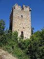
Nograro - defense tower

Ribera de Valderejo - fresco

Tuesta - church portal

Villamaderne - bell gable

Villanañe - Court Column ( roller blind )


Web links
Individual evidence
- ↑ Cifras oficiales de población resultantes de la revisión del Padrón municipal a 1 de enero . Population statistics from the Instituto Nacional de Estadística (population update).
- ↑ Valdegovía / Gaubea - climate tables
- ↑ Valdegovía / Gaubea - Population Development
- ↑ Valdegovía / Gaubea - History
- ↑ Bachicabo - Church
- ↑ Gurendes - place
- ↑ Lalastra - Church
- ↑ Nograro - defense tower
- ↑ Villanañe - Castle
- ↑ Valdegovía / Gaubea - Tourist office
← Previous location: Zalduondo | Valdegovía | Next town: Vitoria-Gasteiz →
Alegría de Álava | Amurrio | Añana | Aramayona | Armiñon | Arraya Maestu | Arrazua Ubarrundia | Arceniega | Aspárrena | Ayala | Baños de Ebro | Barrundia | Berantevilla | Bernedo | Campezo | Cigoitia | Cripán | Cuartango | Elburgo | Elciego | Elvillar | Iruña de Oca | Iruraiz-Gauna | Labastida | Lagrán | Laguardia | Lanciego | Lantarón | Lapuebla de Labarca | Leza | Llodio | Moreda de Álava | Navaridas | Oquendo | Oyón | Peñacerrada | Ribera Alta | Ribera Baja | Salvatierra | Samaniego | San Millán | Urcabustaiz | Valdegovía | Valle de Arana | Villabuena de Álava | Villarreal de Álava | Vitoria-Gasteiz | Yécora | Zalduendo de Álava | Zambrana | Zuia