Isterberg (mountain)
| Isterberg | ||
|---|---|---|
| height | 68 m above sea level NHN | |
| location | Lower Saxony , Germany | |
| Mountains | Teutoburg Forest (foothills) | |
| Coordinates | 52 ° 21 '16 " N , 7 ° 9' 9" E | |
|
|
||
| rock | Sandstone | |
| particularities | Isterberg observation tower | |
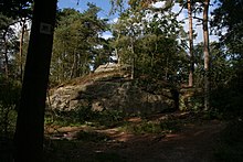
The Isterberg ( 68 m above sea level ) is located in the southern district of Grafschaft Bentheim between the cities of Bad Bentheim in the south and Nordhorn in the north. The mountain is clearly isolated from the (higher) Bentheim and Gildehaus mountain ranges. Despite its low height, the mountain shows itself exposed through its towering sandstone cliffs and the widely visible wooded elevation in the otherwise low marshland between the rivers Dinkel and Vechte . The Isterberg is located in the municipality of the same name Isterberg , near the border with the Netherlands .
etymology
The origin of the name Isterberg is not certain. The most likely origin is from the Middle Low German hester , which means "young beech trunk" and refers to the natural vegetation. Another possibility is a connection with the peoples name Istaevonen or Istraeonen, a community of nations already mentioned by Tacitus in this area. One often finds the explanation that the name comes from a Germanic cult site , which was dedicated to a tribal god Istraz , allegedly an epithet of Wodan . But there is no evidence for this interpretation; There is no archaeological evidence of the existence of a cult site on the Isterberg.
geology
The Isterberg consists essentially of sandstone . The soil of the Upper County of Bentheim consists partly of Mesozoic chalk elevations. The Bentheimer saddle consists of a small remnant of the Mesozoic overburden and represents the last western foothills of the Teutoburg Forest . The rising rock ridge of the Isterberg is located on the north wing of the Bentheimer saddle from the Upper Chalk . The sandstone layer sinks rapidly to the north. On the northern border of the county, near Twist , the sandstone step is already at a depth of 1000 m and contains petroleum .
flora
The slopes of the Isterberg are predominantly made up of pine forest, but oak and beech forests can also be found in parts , which corresponds to the natural vegetation. The forest is rich in mushrooms. The southern slope of the mountain is free from forests as a result of its former use. The nature around the summit has had to cope with a lot of visitors since the opening of the observation tower.
history
From the 12th century onwards, the mining and sale of sandstones brought prosperity to the Counts of Bentheim , as there was a great demand, especially in coastal countries with few stones. The sandstone broken on the southern flank of the Isterberg was a little reddish in color and of a harder quality than the sandstone from Bentheim . The material was therefore suitable for road and hydraulic engineering. In the 19th century, sandstone mining on the Isterberg came to a standstill as it was replaced by cheaper building materials. After that the quarry was used as a garbage dump. It was not until 1986 that a new central landfill was created in Wilsum in the Niedergrafschaft . Since then, the Isterberg landfill has been closed and the site has been renatured. Today, the remains of the old quarry can still be found on the Isterberg.
Observation tower
In 1999 a 35 m high observation tower was opened as a new tourist destination in the region. After 110 steps the platform is reached, where you have a view in all directions. There are the Bentheim Castle and the Schüttorfer steeple visible. When the weather is clear, the view extends as far as the hills of the neighboring Twente and eastwards the first mountain ranges of the Teutoburg Forest can be seen.
The observation tower and sandstone cliffs can be reached via hiking trails from the parking lot with restaurant on the B 403 . The observation tower is open all day, the ascent is free.
swell
- F. Bröckling: Integrated rural regional development and cultivation of cultural landscapes. Inaugural dissertation from the Westphalian Wilhelms University of Münster, Münster 2004.
- M. Kurz, JO Bohnert: Sandstone as natural stone. Requirement, important occurrences, application examples. Oberseminar lecture WS 99/00, registration number 38530.
- J. de Vries: Old Germanic history of religion. Berlin 1957.
Individual evidence
- ↑ a b Map services of the Federal Agency for Nature Conservation ( information )
- ↑ https://educalingo.com/de/dic-de/heister
- ↑ Lookout tower on the website of the municipality of Isterberg


